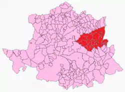
Campo Arañuelo
Campo Arañuelo is a comarca in Cáceres, Extremadura, Spain. It contains the municipalities of Almaraz, Belvís de Monroy, Berrocalejo, Bohonal de Ibor, Casas de Miravete, Casatejada, El Gordo, Higuera de Albalat, Majadas, Mesas de Ibor, Millanes, Navalmoral de la Mata, Peraleda de la Mata, Romangordo, Rosalejo, Saucedilla, Serrejón, Talayuela, Tiétar, Toril, Valdecañas de Tajo, Valdehúncar.[1] Notable for the Dolmen de Guadalperal, the "Spanish Stonehenge".
Campo Arañuelo | |
|---|---|
 | |
| Coordinates: 39°50′46″N 5°36′28″W | |
| Country | Spain |
| Autonomous community | Extremadura |
| Province | Cáceres |
| Area | |
| • Total | 1,491 km2 (576 sq mi) |
| Population (2008) | |
| • Total | 37,644 |
| • Density | 25/km2 (65/sq mi) |
Sources
References
- "Campo Aranuelo". www.geopostcodes.com. Retrieved 2017-12-29.
This article is issued from Wikipedia. The text is licensed under Creative Commons - Attribution - Sharealike. Additional terms may apply for the media files.