Cape Irōzaki
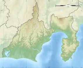
Cape Irōzaki (石廊崎, Irōzaki) is a headland on southernmost point on the Izu Peninsula on the island of Honshu in Japan. It is located within the borders of the town of Minamiizu, Shizuoka and is within the borders of the Fuji-Hakone-Izu National Park. The cape marks the border between Sagami Bay and Suruga Bay, and the border between the Philippine Sea and the Pacific Ocean.
Cape Irōzaki
石廊崎, Irō Zaki, Cape Iro, Irō-saki | |
|---|---|
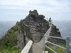 Viewpoint and shimenawa encircling rock at Cape Irōzaki | |
 Cape Irōzaki Irōzaki  Cape Irōzaki Cape Irōzaki (Japan) | |
| Coordinates: 34°36′09″N 138°50′42″E | |
| Location | Izu Peninsula, Japan |
Irōzaki Lighthouse stands on the cape. The cape also contains a Shinto shrine, the Imuro Jinja, which claims to have been founded in the Nara period.[1]
Climate
| Climate data for Cape Irōzaki, Minamiizu (1991−2020 normals, extremes 1939−present) | |||||||||||||
|---|---|---|---|---|---|---|---|---|---|---|---|---|---|
| Month | Jan | Feb | Mar | Apr | May | Jun | Jul | Aug | Sep | Oct | Nov | Dec | Year |
| Record high °C (°F) | 19.2 (66.6) |
20.2 (68.4) |
21.4 (70.5) |
24.3 (75.7) |
26.4 (79.5) |
30.8 (87.4) |
33.9 (93.0) |
33.6 (92.5) |
31.4 (88.5) |
29.6 (85.3) |
25.0 (77.0) |
22.2 (72.0) |
33.9 (93.0) |
| Average high °C (°F) | 11.0 (51.8) |
11.5 (52.7) |
14.0 (57.2) |
17.9 (64.2) |
21.2 (70.2) |
23.6 (74.5) |
27.0 (80.6) |
28.8 (83.8) |
26.3 (79.3) |
22.1 (71.8) |
17.9 (64.2) |
13.4 (56.1) |
19.6 (67.2) |
| Daily mean °C (°F) | 8.2 (46.8) |
8.5 (47.3) |
11.0 (51.8) |
14.9 (58.8) |
18.4 (65.1) |
21.1 (70.0) |
24.5 (76.1) |
26.2 (79.2) |
23.9 (75.0) |
19.7 (67.5) |
15.4 (59.7) |
10.8 (51.4) |
16.9 (62.4) |
| Average low °C (°F) | 5.7 (42.3) |
5.7 (42.3) |
8.1 (46.6) |
12.1 (53.8) |
16.0 (60.8) |
19.1 (66.4) |
22.7 (72.9) |
24.3 (75.7) |
21.8 (71.2) |
17.5 (63.5) |
13.0 (55.4) |
8.3 (46.9) |
14.5 (58.2) |
| Record low °C (°F) | −2.1 (28.2) |
−2.7 (27.1) |
−0.8 (30.6) |
3.4 (38.1) |
8.4 (47.1) |
13.2 (55.8) |
14.8 (58.6) |
17.4 (63.3) |
13.2 (55.8) |
9.3 (48.7) |
3.8 (38.8) |
−0.7 (30.7) |
−2.7 (27.1) |
| Average precipitation mm (inches) | 67.7 (2.67) |
92.4 (3.64) |
147.5 (5.81) |
152.2 (5.99) |
176.9 (6.96) |
236.8 (9.32) |
203.3 (8.00) |
124.9 (4.92) |
186.4 (7.34) |
193.8 (7.63) |
126.6 (4.98) |
72.7 (2.86) |
1,758.2 (69.22) |
| Average snowfall cm (inches) | 0 (0) |
trace | 0 (0) |
0 (0) |
0 (0) |
0 (0) |
0 (0) |
0 (0) |
0 (0) |
0 (0) |
0 (0) |
0 (0) |
trace |
| Average precipitation days (≥ 1.0 mm) | 5.9 | 6.9 | 10.1 | 9.7 | 10.3 | 12.2 | 9.6 | 6.6 | 10.6 | 9.9 | 8.5 | 6.7 | 107 |
| Average snowy days (≥ 1 cm) | 0 | 0.1 | 0 | 0 | 0 | 0 | 0 | 0 | 0 | 0 | 0 | 0 | 0.1 |
| Average relative humidity (%) | 60 | 61 | 66 | 72 | 78 | 85 | 88 | 85 | 80 | 72 | 67 | 62 | 73 |
| Mean monthly sunshine hours | 181.8 | 173.3 | 183.5 | 192.3 | 198.4 | 141.4 | 169.6 | 228.4 | 179.3 | 163.9 | 161.8 | 181.7 | 2,152.7 |
| Source: Japan Meteorological Agency[2][3] | |||||||||||||
Gallery
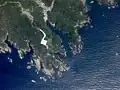 From above
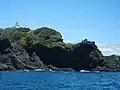 From offshore
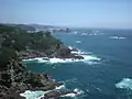 NE view from Irōzaki
References
- "Izu travel: Cape Irozaki", japan-guide.com, retrieved 2017-06-20
- 観測史上1~10位の値(年間を通じての値). JMA. Retrieved March 22, 2022.
- 気象庁 / 平年値(年・月ごとの値). JMA. Retrieved March 22, 2022.
External links
 Media related to Cape Iro at Wikimedia Commons
- Japan Travel Guide
- Japan National Travel Organization (JNTO)
This article is issued from Wikipedia. The text is licensed under Creative Commons - Attribution - Sharealike. Additional terms may apply for the media files.