Cape Spear
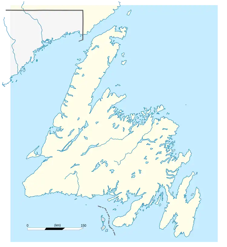
Cape Spear (French: Cap d'Espoir) is a headland located on the Avalon Peninsula of Newfoundland near St. John's in the Canadian province of Newfoundland and Labrador. At a longitude of 52°37' W, it is the easternmost point in Canada and North America, excluding Greenland.[1]
Cape Spear | |
|---|---|
 | |
 Cape Spear Location of Cape Spear in Newfoundland  Cape Spear Location of Cape Spear in Canada  Cape Spear Location of Cape Spear in North America | |
| Coordinates: 47°31′25″N 52°37′10″W | |
| Location | Newfoundland, Canada |
| Elevation | 75 m (246 ft) |
| Current light | |
 | |
| Constructed | 1955 |
| Construction | concrete |
| Height | 13.7 m (45 ft) |
| Markings | white (tower), white (lantern), red (railing) |
| Operator | Parks Canada |
| Heritage | recognized federal heritage building of Canada |
| Focal height | 71 m (233 ft) |
| Range | 20 nmi (37 km; 23 mi) |
| Characteristic | Fl(3) W 15s |
| Original light[2] | |
 | |
| Constructed | 1836 |
| Construction | limestone |
| Markings | white (tower), white (lantern), red and white (dome) |
| Heritage | national Historic Sites of Canada, classified federal heritage building of Canada, heritage lighthouse |
| Deactivated | 1955 |
Cape Spear is within the municipal boundaries of the city of St. John's, located about 12 kilometres (7.5 mi) from downtown St. John's.[3]
The Portuguese named this location Cabo da Esperança, meaning "cape of hope", which became Cap d'Espoir in French and finally "Cape Spear".
Cape Spear is the trailhead/trail end for two components of the East Coast Trail.[4]
History
The Cape Spear region was originally inhabited by Beothuk peoples.[5] Additionally, Mi'kmaq communities practiced a non-sedentary presence in the area,[5][6] harvesting subsistence resources on a temporary basis prior to permanent residency at settlements such as St. George's Bay and Conne River from the nineteenth century onwards.[6] In contrast to European settlers who viewed the cape as a place of significance as the easternmost point in Canada, there is no known archaeological evidence to indicate that Cape Spear was viewed by local Indigenous communities as a place of symbolic geographical importance.[5] According to Fife and Roseman, historically there are "no indications that either the Beothuk or the Mi'kmaq equated Cape Spear with a 'land's end' that was meaningful to them."[5]
World War II

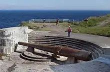
Because of its proximity to convoy routes during the Second World War, a Canadian-manned gun battery including two Lend-Lease ex-US 10-inch M1888 guns on disappearing carriages was installed at Cape Spear to defend the entrance to St. John's harbor. Barracks and underground passages leading to the bunkers were built for the use of troops stationed there. The gun barrels remain in place.[7][8] The bunkers and gun barrels that are located at the site afford a sheltered view of the ocean.
Lighthouses
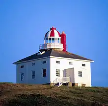
A lighthouse has operated at Cape Spear since September 1836. The original Cape Spear lighthouse was the second lighthouse built in Newfoundland; the first was built in 1810 at Fort Amherst, at the entrance to St. John's Harbour. In 1832, the first legislative assembly for the colony created a lighthouse board. Cape Spear was chosen as the site for a new lighthouse because it was on the rocky eastern coast near the entrance to St. John's harbor.
Nicholas Croke and William Parker, two St. John's builders, won the contract for the lighthouse and work began in 1834 or early in 1835.[9] The first lighthouse was a square wooden building with a tower in the middle containing the light. A foghorn was added in 1878. The first light used at Cape Spear had already been used since 1815 at a lighthouse on Inchkeith on the east coast of Scotland. The original light used seven Argand burners and curved reflectors. This was later replaced by a dioptric lens system; the light was first lit by oil, then acetylene, and finally electricity in 1930.
A new concrete lighthouse was built in 1955, and the original light was moved to the new building.[3]
Lightkeepers
In 1835, dense fog enveloped an approaching warship carrying a VIP visitor to St. John's. The Governor sent out several pilot boats, and a young harbour pilot names James Cantwell succeeded in locating the ship and guiding it safely into harbour. Asked what reward he would like, he requested the job of keeper at the Cape Spear lighthouse, then under construction. It had been promised to another man, Emmanuel Warre, but when Warre died ten years later Cantwell became the second keeper. He served for 35 years; his son Dennis, who had been his assistant, later took over and, with two intermissions, the Cantwell family kept the Cape Spear light for over 150 years.[10]
| Name | Years |
|---|---|
| Emanuel Warre | 1836–1846 |
| James Cantwell | 1846–1879 |
| Austin Oke Sheppard | 1880–1886 |
| Dennis Cantwell | 1886–1909 |
| James Cantwell | 1909–1918 |
| William Cantwell | 1918–1925 |
| Jack Cantwell | 1925–1939 |
| Weston Cantwell | 1939–1944 |
| Frank Cantwell | 1944–1965 |
| Martin Hefferan | 1965–1982 |
| Gerald Cantwell | 1982–1997 |
National Historic Site
The original Cape Spear lighthouse is the oldest surviving lighthouse in Newfoundland and the location has been designated a National Historic Site of Canada.[12] The original lighthouse building and the lightkeeper's residence have been restored to the period of 1839, and are open to the public. The visitor centre includes a gift shop. The lighthouse was designated under the federal Heritage Lighthouse Protection Act in June 2016.[13]
Some visitors attracted by the scenery and history have been swept away by the large and unpredictable waves at Cape Spear, prompting Parks Canada to post numerous warning signs in the area.
Radar Station
Cape Spear Radar Station | |
|---|---|
| Part of United States General Surveillance Radar | |
| Newfoundland | |
 Emblem of the 685th Air Warning Squadron | |
| Type | Radar Station |
| Code | Prime |
| Site information | |
| Controlled by | Newfoundland Base Command |
| Site history | |
| Built | 1942 |
| Built by | United States Army |
| In use | 1943-1945 |
| Garrison information | |
| Garrison | 685th Air Warning Company |
Cape Spear Radar Station (Prime) was a United States Army General Surveillance Ground Radar Early Warning Station in the Dominion of Newfoundland.[14][15] It was built during World War II and responsible for monitoring air traffic from RCAF Torbay and into the Atlantic Ocean.[16][17][18][19] It was closed in 1945.[20]
The site was established in 1942 as a United States Ground Radar Early Warning Station, funded by the United States Army,[21] which stationed the 685th Air Warning Company on the site under operational control of Newfoundland Base Command at Pepperrell Air Force Base.[22][23] Three officers and 49 enlisted men of the 685th were assigned to Cape Spear.[24] It operated an SCR-271 manned Early-warning radar with information sent to a plotting center at Pepperrell AFB to track aircraft. The station was assigned to Royal Canadian Air Force in November 1944, and was given designation "No 42 RU". The RCAF operated the station until 20 June, 1945.[25]
United States Army Air Forces units and assignments
Units:
- Inactivated November 1944
Assignments:
- Newfoundland Base Command, Winter 1943
See also
- Cape St. Charles, the easternmost point of mainland North America
- List of lighthouses in Newfoundland and Labrador
- Heritage Lighthouse Protection Act
Further reading
- Environment Canada – Parks, Cape Spear National Historic Park brochure, 1986.
References
- Staveley, Michael (February 6, 2006). "Cape Spear". The Canadian Encyclopedia. Retrieved August 21, 2019.
- Rowlett, Russ. "Lighthouses of Canada: Southeastern Newfoundland". The Lighthouse Directory. University of North Carolina at Chapel Hill. Retrieved December 30, 2015.
- "Cape Spear Lighthouse National Historic Site". Newfoundland and Labrador Tourism. Retrieved August 21, 2019.
- Brown, David; Findlay, Arthur (2008). 501 Must-Take Journeys. Octopus Publishing Group. ISBN 978-0-7537-1592-5.
- Fife, Wayne; Roseman, Sharon R. "Where North America Ends," The Tourism Imaginary and Pilgrimages to the Edges of the World. Tourism and Cultural Change, vol. 44. Channel View Publications, 2015. Web. p.143-144. Retrieved from Google Books; March 12, 2017. ISBN 9781845415235
- Martijn, Charles A. "Early Mikmaq Presence in Southern Newfoundland: An Ethnohistorical Perspective, c.1500-1763". Vol. 19, No 1: The New Early Modern Newfoundland: Part 2, Newfoundland and Labrador Studies. St. John's, Newfoundland: Memorial University, 2003. Web. n. pag. Retrieved March 12, 2017. ISSN 1715-1430
- Berhow, Mark A., ed. (2015). American Seacoast Defenses, A Reference Guide, Third Edition. McLean, Virginia: CDSG Press. p. 225. ISBN 978-0-9748167-3-9.
- "Defenses in Newfoundland, Canada". Coast Defense Study Group. May 24, 2016.
- "Cape Spear Lighthouse National Historic Site of Canada". Parks Canada. Retrieved June 26, 2014.
- Molloy, David (1994). The First Landfall - Historic Lighthouses of Newfoundland and Labrador. Breakwater. p. 53. ISBN 1550810960.
- Cape Spear Lighthouse Archived March 4, 2016, at the Wayback Machine Lighthouse Friends
- Cape Spear Lighthouse. Canadian Register of Historic Places. Retrieved July 1, 2012.
- "Cape Spear Lighthouse Receives Heritage Lighthouse Designation". News, Government of Canada. Government of Canada. June 30, 2016. Archived from the original on March 30, 2017. Retrieved March 29, 2017.
Cape Spear Lighthouse is one of 76 lighthouses from across Canada to be designated since the Act was adopted in 2008, with more designations to come.
- "Searching the Skies, The Legacy of the United States Cold War Defense Radar Program" (PDF).
- "Cape Spear Battery - FortWiki Historic U.S. And Canadian Forts".
- Cardoulis, John N (1990). A Friendly Invasion (The American Military in Newfoundland: 1940-1990). St John's: Breakwater Books Ltd. p. 25. ISBN 0-920911-85-4.
- "Fort Cape Spear - Cape Spear, Newfoundland and Labrador - Historic Forts on Waymarking.com". www.waymarking.com.
- "The CADIN Pinetree Line Locations".
- Smallwood, Joseph R (1981). Encyclopedia of Newfoundland and Labrador (PDF). St John's: Newfoundland Book Publishers (1967) Ltd. p. 340. ISBN 0920508146.
- "Other American Stations".
- "A Handbook of Aerospace Defense Organization 1946 - 1980" (PDF). Archived from the original (PDF) on February 13, 2016. Retrieved July 3, 2023.
- Group, NBC (1997). A History of the Air Defence of Canada 1948-1997. Washington, DC: Commander Fighter Group. p. 148. ISBN 0-9681973-0-2.
- "Newfoundland Forts".
- "Cape Spear, NF".
- "Encyclopedia of Newfoundland and Labrador" (PDF).
![]() This article incorporates public domain material from the Air Force Historical Research Agency.
This article incorporates public domain material from the Air Force Historical Research Agency.
- Cornett, Lloyd H. and Johnson, Mildred W., A Handbook of Aerospace Defense Organization 1946 - 1980, Archived February 13, 2016, at the Wayback Machine Office of History, Aerospace Defense Center, Peterson AFB, CO (1980)
External links
- Parks Canada site Archived October 9, 2004, at the Wayback Machine
- Aids to Navigation Canadian Coast Guard