Cave Spring, Oklahoma
Cave Spring is a census-designated place (CDP) in Adair County, Oklahoma, United States. Part of the Cherokee Nation, it was first listed as a CDP prior to the 2020 census.[2]
Cave Spring, Oklahoma | |
|---|---|
 Cave Spring  Cave Spring | |
| Coordinates: 35°43′45″N 94°45′27″W | |
| Country | United States |
| State | Oklahoma |
| County | Adair |
| Area | |
| • Total | 4.89 sq mi (12.66 km2) |
| • Land | 4.85 sq mi (12.57 km2) |
| • Water | 0.03 sq mi (0.08 km2) |
| Elevation | 1,093 ft (333 m) |
| Population (2020) | |
| • Total | 74 |
| • Density | 15.25/sq mi (5.89/km2) |
| Time zone | UTC-6 (Central (CST)) |
| • Summer (DST) | UTC-5 (CDT) |
| ZIP Codes | |
| Area code(s) | 918/539 |
| FIPS code | 40-12910 |
| GNIS feature ID | 2806995[2] |
The CDP is in southwestern Adair County, bordered to the southeast by Bunch and to the northeast by Lyons Switch. Bunch Road crosses the southeast side of the community, leading south 2.5 miles (4.0 km) to Bunch and northeast 12 miles (19 km) to Stilwell, the county seat.
The CDP is hilly and mostly forested, with elevations ranging from 800 to 1,200 feet (240 to 370 m) above sea level. Sallisaw Creek, a south-flowing tributary of the Arkansas River, forms the boundary between Cave Spring and Bunch.
References
- "ArcGIS REST Services Directory". United States Census Bureau. Retrieved September 20, 2022.
- U.S. Geological Survey Geographic Names Information System: Cave Spring, Oklahoma
- "Census of Population and Housing". Census.gov. Retrieved June 4, 2016.
Municipalities and communities of Adair County, Oklahoma, United States | ||
|---|---|---|
| City | 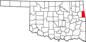 Adair County map | |
| Towns | ||
| CDPs | ||
| Other communities | ||
| Indian reservation | ||
| Footnotes | ‡This populated place also has portions in an adjacent county or counties | |
This article is issued from Wikipedia. The text is licensed under Creative Commons - Attribution - Sharealike. Additional terms may apply for the media files.