Cedar Grove, Queensland
Cedar Grove is a mixed-use locality in the City of Logan, Queensland, Australia.[2] In the 2016 census, Cedar Grove had a population of 2,041 people.[1]
| Cedar Grove Logan City, Queensland | |||||||||||||||
|---|---|---|---|---|---|---|---|---|---|---|---|---|---|---|---|
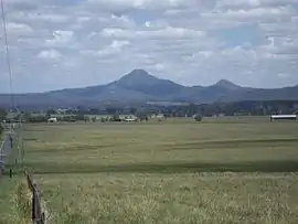
 Flinders Peak from Cedar Grove, 2016 | |||||||||||||||
 Cedar Grove | |||||||||||||||
| Coordinates | 27.8600°S 152.9744°E | ||||||||||||||
| Population | 2,041 (2016 census)[1] | ||||||||||||||
| • Density | 113.4/km2 (293.7/sq mi) | ||||||||||||||
| Postcode(s) | 4285 | ||||||||||||||
| Area | 18.0 km2 (6.9 sq mi) | ||||||||||||||
| Time zone | AEST (UTC+10:00) | ||||||||||||||
| Location |
| ||||||||||||||
| LGA(s) | Logan City | ||||||||||||||
| State electorate(s) | Scenic Rim | ||||||||||||||
| Federal division(s) | Wright | ||||||||||||||
| |||||||||||||||
Geography
The western and part of the northern boundary of Cedar Grove follows the Logan River. On the river on the northern boundary is the Cedar Grove Weir. The Mount Lindesay Highway loosely forms the eastern boundary of the locality.[3]
The eastern edge of the locality and the west of the locality are used for agriculture, a mixture of grazing on native vegetation and crop growing. A strip through the centre of the locality between the eastern and western agricultural areas is residential.[3]
History

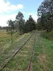
Cedar Grove railway station (27.8617°S 152.991944°E) was on the disused Beaudesert railway line from Bethania to Beaudesert.[4] The line opened on 16 May 1888.[5] When the railway line to Beaudesert was built in 1888, the station was built in the area known as Cedar Pocket.[6] The station appears on an 1888 map as Cedar Pocket South railway station.[7]
Jimboomba Timber Reserve Provisional School opened circa 1899. In 1906, it was renamed Martindale Provisional School. On 1 January 1909, it became Martindale State School. It was in the area of Gittins Road (now in Riverbend).[8] It closed in 1922.[9] The school building was then relocated to 19-29 Cedar Grove Road (27.8622°S 152.9975°E),[10] where it opened as Cedar Grove State School in 1923.[11] It closed in 1965.[12]
The Cedar Grove Weir on the Logan River was built between March 2007 and January 2008. It supplies water into the South East Queensland Water Grid.[13]
Formerly in the Shire of Beaudesert, Cedar Grove became part of Logan City following the local government amalgamations in March 2008.
In the 2011 census, Cedar Grove had a population of 2,020.[14]
In the 2016 census, Cedar Grove had a population of 2,041 people.[1]
Education
There are no schools in Cedar Grove. The nearest government primary school is Woodhill State School in neighbouring Woodhill to the south. The nearest government secondary schools are Flagstone State Community College in Flagstone to the north and Beaudesert State High School in Beaudesert to the south.[3]
References
- Australian Bureau of Statistics (27 June 2017). "Cedar Grove (SSC)". 2016 Census QuickStats. Retrieved 20 October 2018.
- "Cedar Grove – locality in City of Logan (entry 45257)". Queensland Place Names. Queensland Government. Retrieved 27 December 2020.
- "Queensland Globe". State of Queensland. Retrieved 2 June 2022.
- "Cedar Grove – railway station in Logan City (entry 6750)". Queensland Place Names. Queensland Government. Retrieved 2 April 2020.
- Kerr, John (1990). Triumph of narrow gauge : a history of Queensland Railways. Boolarong Publications. p. 224. ISBN 978-0-86439-102-5.
- "Cedar Grove". Suburbs. Logan City Council. Archived from the original on 24 March 2019. Retrieved 2 April 2020.
- "Moreton 40 Chain map AG2 series sheet 8 south" (Map). Queensland Government. 1888. Retrieved 5 December 2022.
- "Jimboomba". Logan City Council. Archived from the original on 8 March 2020. Retrieved 29 April 2020.
- Queensland Family History Society (2010), Queensland schools past and present (Version 1.01 ed.), Queensland Family History Society, ISBN 978-1-921171-26-0
- "Flinders" (Map). Queensland Government. 1954. Archived from the original on 29 April 2020. Retrieved 30 April 2020.
- "Cedar Grove School". Beaudesert Times. 26 January 1923. Retrieved 5 December 2022.
- "Agency ID 6292, Cedar Grove State School". Queensland State Archives. Retrieved 11 May 2014.
- "Logan River Catchment Early Works - Cedar Grove Weir". Entura. Archived from the original on 13 March 2022. Retrieved 2 June 2022.
- Australian Bureau of Statistics (31 October 2012). "Cedar Grove (SSC)". 2011 Census QuickStats. Retrieved 6 May 2014.
External links
- "Cedar Grove and Cedar Vale". Queensland Places. Centre for the Government of Queensland, University of Queensland.
- "Cedar Grove". Logan City Council.