Centralia, Washington
Centralia (/sɛnˈtreɪliə/) is a city in Lewis County, Washington, United States. It is located along Interstate 5 near the midpoint between Seattle and Portland, Oregon. The city had a population of 18,183 at the 2020 census.[3] Centralia is twinned with Chehalis, located to the south near the confluence of the Chehalis and Newaukum rivers.
Centralia | |
|---|---|
 Centralia downtown historic district | |
 Flag Logo | |
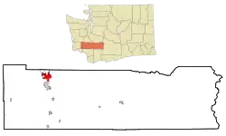 Location of Centralia, Washington | |
| Coordinates: 46°43′14″N 122°57′41″W | |
| Country | United States |
| State | Washington |
| County | Lewis |
| Government | |
| • Type | Council–manager |
| • Mayor | Kelly Smith Johnston[1] |
| Area | |
| • Total | 7.81 sq mi (20.22 km2) |
| • Land | 7.62 sq mi (19.74 km2) |
| • Water | 0.19 sq mi (0.48 km2) |
| Elevation | 187 ft (57 m) |
| Population | |
| • Total | 18,183 |
| • Estimate (2021)[4] | 18,629 |
| • Density | 2,386.22/sq mi (921.12/km2) |
| Time zone | UTC-8 (PST) |
| • Summer (DST) | UTC-7 (PDT) |
| ZIP code | 98531 |
| Area code | 360 |
| FIPS code | 53-11160 |
| GNIS feature ID | 1503899[5] |
| Website | cityofcentralia.com |
History
In the 1850s and 1860s, Centralia's Borst Home, at the confluence of the Chehalis and Skookumchuck Rivers, was the site of a toll ferry, and the halfway stopping point for stagecoaches operating between Kalama, Washington and Tacoma. In 1850, J. G. Cochran and his wife Anna were led there via the Oregon Trail by their adopted son, George Washington, a free African-American. The family feared Washington would be forced into slavery if they stayed in Missouri after the passage of the Compromise of 1850. Cochran filed a donation land claim near the Borst Home in 1852 and was able to sell his claim to Washington for $6,000 because unlike the neighboring Oregon Territory, there was no restriction against passing legal ownership of land to African Americans in the newly formed Washington Territory.[6]
Upon hearing of the imminent arrival of the Northern Pacific Railway (NP) in 1872, Washington and his wife, Mary Jane, filed a plat for the town of Centerville, naming the streets with a Biblical theme, and offering lots for $10 each with one lot free to buyers who built houses. Washington also donated land for a city park, a cemetery, and a Baptist church.[7] Responding to new settlers' concern about a town in Klickitat County with the same name, the town was renamed Centralia by 1883, as suggested by a recent settler from Centralia, Illinois, and officially incorporated on February 3, 1886.[8] The town's population boomed, then collapsed in the Panic of 1893, when the NP went bankrupt; entire city blocks were offered for as little as $50 with no takers. Washington (despite facing racial prejudice from some newcomers) made personal loans and forgave debt to keep the town afloat until the economy stabilized; the city then boomed again based on the coal, lumber and dairying industries. When Washington died in 1905, all businesses in the town closed, and 5,000 mourners attended his funeral.[6] The city bestowed an honor to Washington in 2023 by declaring August 15th, his recognized birthday, as Centralia's Founder's Day.[9]
The boom lasted until November 11, 1919, when the infamous Centralia Massacre occurred. Spurred on by local lumber barons, American Legionnaires (many of whom had returned from WWI to find their jobs filled by pro-union members of the Industrial Workers of the World (IWW)), used the Armistice Day parade to attack the IWW hall. Marching unarmed,[10] the Legionnaires broke from the parade and stormed the hall in an effort to bust union organizing efforts by what was seen to be a Bolshevik-inspired labor movement. IWW workers including recently returned WWI veteran Wesley Everest, stood their ground, engaged and killed four Legionnaires. Everest was captured, jailed and then brutally lynched. Other IWW members were also jailed. The event made international headlines, and coupled with similar actions in Everett, Washington and other lumber towns, stifled the American labor movement until the economic devastation of the 1930s Great Depression changed opinions about labor organizations.[11]
The town's name was originally a reference to the town's location as the midway point between Tacoma and Kalama, which were originally the NP's Washington termini. This central moniker continued to have longevity when it became the midpoint between Seattle and Portland, Oregon after the constructions of Interstate 5 and its predecessor, U.S. Route 99.[12]
Geography
According to the United States Census Bureau, the city has a total area of 7.56 square miles (19.58 km2), of which, 7.42 square miles (19.22 km2) is land and 0.14 square miles (0.36 km2) is water.[13]
Climate
This region experiences warm (but not hot) and dry summers, with no average monthly temperatures above 71.6 °F. According to the Köppen Climate Classification system, Centralia has a warm-summer Mediterranean climate, abbreviated "Csb" on climate maps.[14] Temperatures are usually quite mild, although Centralia is generally warmer in the summer and colder in the winter than locations further north along the Puget Sound.
| Climate data for Centralia, Washington, 1991–2020 normals, extremes 1893–present | |||||||||||||
|---|---|---|---|---|---|---|---|---|---|---|---|---|---|
| Month | Jan | Feb | Mar | Apr | May | Jun | Jul | Aug | Sep | Oct | Nov | Dec | Year |
| Record high °F (°C) | 68 (20) |
75 (24) |
85 (29) |
93 (34) |
98 (37) |
107 (42) |
107 (42) |
103 (39) |
100 (38) |
92 (33) |
75 (24) |
73 (23) |
107 (42) |
| Mean maximum °F (°C) | 57.1 (13.9) |
60.8 (16.0) |
69.3 (20.7) |
77.8 (25.4) |
84.8 (29.3) |
88.0 (31.1) |
93.7 (34.3) |
93.1 (33.9) |
87.6 (30.9) |
76.0 (24.4) |
62.3 (16.8) |
56.1 (13.4) |
96.8 (36.0) |
| Average high °F (°C) | 46.1 (7.8) |
49.5 (9.7) |
54.1 (12.3) |
59.5 (15.3) |
66.6 (19.2) |
71.1 (21.7) |
77.5 (25.3) |
78.2 (25.7) |
72.6 (22.6) |
61.1 (16.2) |
50.7 (10.4) |
45.0 (7.2) |
61.0 (16.1) |
| Daily mean °F (°C) | 40.2 (4.6) |
41.7 (5.4) |
45.0 (7.2) |
49.3 (9.6) |
55.5 (13.1) |
60.1 (15.6) |
65.2 (18.4) |
65.5 (18.6) |
60.5 (15.8) |
51.9 (11.1) |
43.9 (6.6) |
39.4 (4.1) |
51.5 (10.8) |
| Average low °F (°C) | 34.2 (1.2) |
33.9 (1.1) |
35.9 (2.2) |
39.1 (3.9) |
44.4 (6.9) |
49.1 (9.5) |
52.9 (11.6) |
52.8 (11.6) |
48.4 (9.1) |
42.7 (5.9) |
37.1 (2.8) |
33.9 (1.1) |
42.0 (5.6) |
| Mean minimum °F (°C) | 22.8 (−5.1) |
23.2 (−4.9) |
27.0 (−2.8) |
30.8 (−0.7) |
35.3 (1.8) |
41.8 (5.4) |
45.9 (7.7) |
45.8 (7.7) |
39.8 (4.3) |
31.1 (−0.5) |
25.2 (−3.8) |
22.2 (−5.4) |
17.3 (−8.2) |
| Record low °F (°C) | −4 (−20) |
0 (−18) |
13 (−11) |
20 (−7) |
27 (−3) |
31 (−1) |
33 (1) |
35 (2) |
24 (−4) |
20 (−7) |
5 (−15) |
0 (−18) |
−4 (−20) |
| Average precipitation inches (mm) | 5.85 (149) |
4.24 (108) |
4.39 (112) |
3.24 (82) |
2.44 (62) |
1.53 (39) |
0.50 (13) |
0.84 (21) |
1.59 (40) |
4.00 (102) |
6.53 (166) |
6.44 (164) |
41.59 (1,058) |
| Average snowfall inches (cm) | 3.4 (8.6) |
1.4 (3.6) |
0.5 (1.3) |
0.0 (0.0) |
0.0 (0.0) |
0.0 (0.0) |
0.0 (0.0) |
0.0 (0.0) |
0.0 (0.0) |
0.0 (0.0) |
0.4 (1.0) |
0.9 (2.3) |
6.6 (16.8) |
| Average precipitation days (≥ 0.01 in) | 21.7 | 17.6 | 19.5 | 17.1 | 12.1 | 8.9 | 3.9 | 4.6 | 8.1 | 15.6 | 21.1 | 22.1 | 172.3 |
| Average snowy days (≥ 0.1 in) | 1.6 | 0.6 | 0.3 | 0.1 | 0.0 | 0.0 | 0.0 | 0.0 | 0.0 | 0.0 | 0.2 | 0.6 | 3.4 |
| Source 1: NOAA[15] | |||||||||||||
| Source 2: National Weather Service[16] | |||||||||||||
Demographics
| Census | Pop. | Note | %± |
|---|---|---|---|
| 1890 | 2,026 | — | |
| 1900 | 1,600 | −21.0% | |
| 1910 | 7,311 | 356.9% | |
| 1920 | 7,549 | 3.3% | |
| 1930 | 8,058 | 6.7% | |
| 1940 | 7,414 | −8.0% | |
| 1950 | 8,657 | 16.8% | |
| 1960 | 8,586 | −0.8% | |
| 1970 | 10,054 | 17.1% | |
| 1980 | 11,555 | 14.9% | |
| 1990 | 12,101 | 4.7% | |
| 2000 | 14,742 | 21.8% | |
| 2010 | 16,336 | 10.8% | |
| 2020 | 18,183 | 11.3% | |
| 2021 (est.) | 18,629 | [4] | 2.5% |
| U.S. Decennial Census[17] 2020 Census[3] | |||
2010 census
As of the census[18] of 2010, there were 16,336 people, 6,640 households, and 3,867 families residing in the city. The population density was 2,201.6 inhabitants per square mile (850.0/km2). There were 7,265 housing units at an average density of 979.1 per square mile (378.0/km2). The racial makeup of the city was 85.1% White, 0.6% African American, 1.4% Native American, 1.0% Asian, 0.3% Pacific Islander, 7.4% from other races, and 4.1% from two or more races. Hispanic or Latino people of any race were 16.1% of the population.
There were 6,640 households, of which 31.6% had children under the age of 18 living with them, 37.7% were married couples living together, 14.4% had a female householder with no husband present, 6.1% had a male householder with no wife present, and 41.8% were non-families. 33.8% of all households were made up of individuals, and 15.8% had someone living alone who was 65 years of age or older. The average household size was 2.41 and the average family size was 3.06.
The median age in the city was 34.8 years. 24.7% of residents were under the age of 18; 10.7% were between the ages of 18 and 24; 25.7% were from 25 to 44; 22.3% were from 45 to 64; and 16.6% were 65 years of age or older. The gender makeup of the city was 48.3% male and 51.7% female.
2000 census
As of the census of 2000, there were 14,742 people, 5,943 households, and 3,565 families residing in the city. The population density was 1,990.6 people per square mile (768.1/km2). There were 6,510 housing units at an average density of 879.0 per square mile (339.2/km2). The racial makeup of the city was 89.76% White, 0.44% African American, 1.25% Native American, 0.94% Asian, 0.30% Pacific Islander, 4.94% from other races, and 2.38% from two or more races. Hispanic or Latino people of any race were 10.22% of the population.
There were 5,943 households, out of which 29.4% had children under the age of 18 living with them, 41.7% were married couples living together, 13.0% had a female householder with no husband present, and 40.0% were non-families. 32.7% of all households were made up of individuals, and 16.9% had someone living alone who was 65 years of age or older. The average household size was 2.40 and the average family size was 3.02.
In the city, the population was spread out, with 25.2% under the age of 18, 10.5% from 18 to 24, 25.7% from 25 to 44, 19.4% from 45 to 64, and 19.2% who were 65 years of age or older. The median age was 37 years. For every 100 females, there were 89.8 males. For every 100 females age 18 and over, there were 86.6 males.
The median income for a household in the city was $30,078, and the median income for a family was $35,684. Males had a median income of $31,595 versus $22,076 for females. The per capita income for the city was $16,305. About 13.6% of families and 18.0% of the population were below the poverty line, including 24.4% of those under age 18 and 10.8% of those age 65 or over.
Economy and employment
Founded as a railroad town, Centralia's economy was originally dependent on such extractive industries as coal, lumber and agriculture. At one time, five railroad lines crossed in Centralia, including the Union Pacific Railroad, Northern Pacific Railway, Milwaukee Road, Great Northern Railroad and a short line.
The explosion of Mount St. Helens on May 18, 1980, devastated the local lumber industry, as 12 million board feet of stockpiled lumber and 4 billion board feet of salable timber was damaged or destroyed.[19] Unemployment surged to double digits, and the town lost most of its retail base.[20]
In 1988, London Fog opened the first factory outlet store in the Northwest, choosing the location because it was the midpoint between major northwest cities. Their success spawned the region's first factory outlet center, creating a tourist shopping destination. This led in turn to the redevelopment of the vintage downtown marketplace as an antique, art and specialty store destination.[21]
The Port of Centralia, created in 1986 and located northwest of the city center near Fords Prairie, is a complex of industrial and mixed-use economic development in the municipality.[21]
Chehalis Mints was founded in the city in 1994 and produces various mint and mint chocolate candies, with a specialty in butter mints. The company's products are sold primarily in the Pacific Northwest.[22]
As extractive industries faced decline, Centralia's development refocused on freeway oriented food, lodging, retail and tourism, as well as regional shipping and warehousing facilities, leading to 60 percent growth in population since the 1980s. Additional development of regional distribution and transportation facilities, along with in-migration from retirees from more populated counties to the north, have helped diversify the economy, though unemployment remains stubbornly high and per-capita income well below the state average.
TransAlta Coal Mine and Power Plant
On November 28, 2006, it was announced that TransAlta, the largest employer in Centralia and operator of the Centralia Coal Mine and Centralia Power Plant, would eliminate 600 coal mining jobs.[23] Despite fears to the contrary, there was little noticeable economic effect upon the City of Centralia as a result. Data indicated that Centralia was experiencing growth both in its light industrial areas as well as its core business district, the historic downtown Centralia.[24] The mine has since undergone a reclamation to fill, regrade, dredge water sources, and plant new trees. As of 2023, half of the reclamation project was considered complete. The site has been determined as a potential recreation area once the recovery processes are complete.[25]
The power plant, completed in two unit stages in the early 1970s and owned by TransAlta since 2000, is Washington state's last energy factory powered by coal. At its peak, it generated energy ample enough to power Los Angeles. The plant is situated on 11,000 acres (4,500 ha) and is expected to permanently close in 2025 based on an agreement reached with the state in 2011. The first phase of the shutdown was completed in 2020. The energy produced until its closure is used by Puget Sound Energy (PSE) and according to 2022 figures, 14.5% of PSE's electric load came from the TransAlta coal plant, enough to supply power to 300,000 homes. Future plans include the operating of several green energy facilities, including generating power via hydrogen and fusion, and the decommissioning of the Centralia Coal Mine is expected to incorporate renewable energy machinery as the coal plant closes. The company created a $20 million fund for training and educational work programs for remaining employees of the plant.[25]
Arts and culture
Festivals and events
Centralia has hosted the annual Hub City Car Show since the early 2000s. The one-day event, usually held in late summer, is held in the downtown district, shutting down the main artery through the historic center of the city.[26][27]
Historic buildings and sites

The Carnegie Library[28] is located in Washington Park and was originally built in 1913 followed by a remodel in 1977–78. The library is now part of the Timberland Regional Library system.[29]
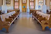
Centralia Union Depot was built in 1912 and features red brick architecture, vintage oak benches, and internal and external woodworking throughout. The renovated depot, listed on the National Register of Historic Places, is currently served by Amtrak and Twin Transit.
Located in Fort Borst Park are the Fort Borst blockhouse and the Borst Home. The blockhouse is a log structure that was built in 1856 and was used as grain storage during local wars with Native Americans. Originally constructed near the confluence of the Chehalis and Skookumchuck rivers, the building was moved twice, in 1915 due to an alteration of the Chehalis River's course, and then in 1922 to its present-day site in the park. Joseph Borst, an Oregon Trail migrant, purchased the blockhouse from the U.S. government in 1857 and his family would use the building as a residence until he built the Borst Home next to the structure in 1864. The house was constructed near a toll ferry crossing that existed at the time and the home site contains a replicated one-room schoolhouse and a church. The Borst Home, but not the blockhouse, is listed on the National Register of Historic Places (NRHP).[30]
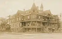
Centralia is host to various other NRHP sites including the George E. Birge House, the Hubbard Bungalow, and the Wesley Everest Gravesite. The NRHP-listed Centralia Downtown Historic District is home to McMenamin's Olympic Club Hotel & Theater[31] a registered historic hotel and restaurant that opened in 1908.
Music
Seattle-based rock band Harvey Danger used Centralia as a metaphor in its song "Moral Centralia," found on the 2005 album Little by Little.
Public art
Murals are found throughout historic downtown Centralia. Examples include murals depicting the founder of Centralia (Centerville) named George Washington, Buffalo Bill and his Wild West Show and an abstract mural depicting the 1919 Armistice Day Centralia Massacre, also known as the Wobbly War.
Centralia is part of the ARTrails of Southwest Washington initiative. The cooperative, begun in 2003, showcases local artists, art studios and galleries throughout the region, and holds an annual autumnal studio tour that incorporates events in smaller towns within Lewis County.[32][33] ARTrails opened a gallery for its members in the city in 2015[34] and the Centralia Train Depot is used as the nexus of the tour.[35]
Parks and recreation
George Washington Park, in Centralia's downtown district, is home to the Centralia Timberland Library. The park contains the statue, The Sentinel, and the Freedom Walk War Memorial, both honoring Centralia soldiers who lost their lives during World War I. The statue, listed on the National Register of Historic Places,[36] is also a remembrance to the deaths that occurred during the city's 1919 Armistice Day Riot. The Freedom Walk was built in 1993 and presents the individual names of veterans who perished in military combat since the First World War.[37]
Along the Skookumchuck River, near Hayes Lake in the shopping district, lies the 4.5-acre (1.8 ha) Riverside Park. The land, originally developed by a local rotary club, was donated to the city in 1983. The park contains a 44,000 square feet (4,087.73 m2) skate park and a covered playground.[38] The Fort Borst blockhouse was temporarily relocated to the site in the late 1910s.[39]
A sports complex known as Bob Peters Field is situated at the Centralia College campus. Named after a long-serving athletic director at the school, the 4.0-acre (1.6 ha) site hosts fields for baseball, softball, and soccer. It was completed in 2023 and was built, in part, by using over $3 million of student fees.[40]
A community pool, known as the Veteran's Memorial Pearl Street Pool, was built in the 1950s in Centralia's downtown district.[41] Known succinctly as the Pearl Street Pool, it once contained a bathhouse.[42] The city owned and oversaw operations of the facility until the 1980s when it was transferred to a local nonprofit. Centralia would regain possession of the pool in 2008 but would shut it down in 2011 due to a combination of expensive repairs and maintenance, lack of funds, and a decrease in staffing.[41] Since its 2011 cessation, various city and community groups have made improvements to the recreation parcel by adding a playground and spray park.[43] Despite several attempts to raise funds by tax levies and bonds to cover the $5 million renovation and rebuild costs, the pool has remained unfunded since its closure. In 2022, the city council voted to place the decision to perpetually close the site on a voter ballot but in 2023 rescinded the decision after another failed levy attempt and made the ceasing of operations at the pool permanent.[42] The city would fill the pool with dirt, for liability and injury concerns, months later.[44] A second community pool, created by a bond passed in the 1970s, is run under a joint contract between the city, the school district, and a local fitness company. Given the moniker, the Centralia Community Pool, it is open to all residents but priority for use of the facility is first given to children and school activities.[45]
Fort Borst Park
Centralia's largest park is Fort Borst Park located at the junction of the Chehalis and Skookumchuck rivers. The park contains the original Borst Home, a reproduced schoolhouse, and replicated pioneer church from the 1860s that was completed in 2021.[46][47] The park hosts an annual Christmas-themed "Fort Borst Park Drive-Through Lights" that includes a food drive and also raises funds for the park department.[48]
Located within Fort Borst Park is Centralia's NW Sports Hub. Officially opened in 2014, the 76,500 square feet (7,107.08 m2) complex is owned by a various group of Centralia government bodies and businesses. The hub contains enclosed buildings that house numerous volleyball and basketball courts and fields for indoor baseball and soccer. An attached outdoor component encompasses a mixture of previously built Little League and adult baseball fields, tennis courts, additional soccer fields, and the Centralia High School track stadium that can seat 3,500 people. The use of the complex is given first priority to the community over events held by private entities[49] but the sports compound hosts various tournaments for high school sports, competitions for the Greater Seattle League, and planned college scouting events for local athletes.[50]
Government and politics
Centralia is a non-charter code city with a council–manager form of government. The City Council consists of seven members with positions one through three being at-large positions.
Although slightly less so than Lewis County as a whole, Centralia is conservative and leans Republican.
Education
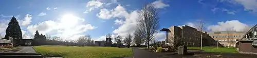
Centralia College
Centralia College is the oldest continuously operating junior college in the state of Washington, and was founded on September 14, 1925.[51]
Media
Newspaper
Centralia's leading newspaper is The Chronicle, ranked seventeenth in the state based on weekday circulation,[52] and serves most of Lewis County. There are also several community-based newspapers that are published bi-weekly, such as The Lewis County News and The East County Journal.
Radio
The Centralia area is served by two AM radio stations, KELA - 1470 AM and KITI - 1420 AM. The FM station, KCED - 91.3 FM operates from within the city. Radio broadcasts are accessible from nearby Chehalis stations KMNT - 104.3 FM and KACS - 90.5 FM. Centralia is able to pick up Winlock station KITI-FM - 95.1 FM as well as the transmission of KZTM - 102.9 FM from Olympia.
Infrastructure
Amtrak, the national passenger rail system, provides service to Centralia station, stopping at the town's renovated 1912 railroad depot. Amtrak train 11, the southbound Coast Starlight, is scheduled to depart Centralia at 11:45am with service to Kelso-Longview, Portland, Sacramento, Emeryville, California (with bus connection to San Francisco), and Los Angeles. Amtrak train 14, the northbound Coast Starlight, is scheduled to depart Centralia at 5:57pm daily with service to Olympia-Lacey, Tacoma and Seattle. Amtrak Cascades trains, operating as far north as Vancouver, British Columbia and as far south as Eugene, Oregon, serve Centralia several times daily in both directions. BNSF trains in Centralia's downtown rail yard and on the mainline serve local and regional shippers, but can affect the timeliness of Amtrak service and are a noisy reminder of the days of the town's heyday as the crossroads of four major railroads (Union Pacific, Milwaukee Road, Great Northern and Northern Pacific).
Notable people
- Charlie Albright, pianist
- Calvin Armstrong, American football player
- Ann Boleyn, singer
- Bob Coluccio, baseball player
- Merce Cunningham, modern dancer
- Noah Gundersen, singer
- Soren Johnson, video game designer
- James Kelsey, sculptor
- Craig McCaw, entrepreneur
- Angela Meade, operatic soprano
- C. D. Moore, U.S. Air Force general
- Patricia Anne Morton, first woman to serve as a Diplomatic Security special agent[53]
- Lyle Overbay, baseball player
- Tavita Pritchard, American football coach
- Jimmy Ritchey, country music songwriter and record producer
- Detlef Schrempf, NBA player
References
- "Kelly Smith Johnston". City of Centralia. Retrieved April 4, 2022.
- "2019 U.S. Gazetteer Files". United States Census Bureau. Retrieved August 7, 2020.
- "Explore Census Data". United States Census Bureau. Retrieved March 12, 2022.
- "City and Town Population Totals: 2020-2021". United States Census Bureau. June 22, 2022. Retrieved June 22, 2022.
- "Centralia". Geographic Names Information System. United States Geological Survey, United States Department of the Interior.
- Kit Oldham, George and Mary Jane Washington founded the town of Centerville (now Centralia) on January 8, 1875, HistoryLink, February 23, 2003. Accessed online 12 March 2008.
- Johnson, Kraen (January 18, 2007). "Centralia, Washington (1875–)". BlackPast.
- Oldham, Kit (February 23, 2003). "George and Mary Jane Washington found the town of Centerville (now Centralia) on January 8, 1875". HistoryLink. Retrieved February 20, 2020.
- Sexton, Owen (July 12, 2023). "Centralia City Council Finally Makes Founder's Day Official". The Chronicle. Retrieved July 19, 2023.
- "The Free and the Brave". August 23, 2020.
- Wobbly War: The Centralia Story, John McClellan, ISBN 0917048628
- Ott, Jennifer (February 12, 2008). "Centralia — Thumbnail History". HistoryLink. Retrieved February 20, 2020.
- "US Gazetteer files 2010". United States Census Bureau. Archived from the original on January 12, 2012. Retrieved December 19, 2012.
- "Centralia, Washington Köppen Climate Classification (Weatherbase)".
- "U.S. Climate Normals Quick Access – Station: Centralia, WA". National Oceanic and Atmospheric Administration. Retrieved December 31, 2022.
- "NOAA Online Weather Data – NWS Seattle". National Weather Service. Retrieved December 31, 2022.
- "U.S. Decennial Census". Census.gov. Retrieved June 7, 2013.
- "U.S. Census website". United States Census Bureau. Retrieved December 19, 2012.
- https://pubs.usgs.gov/gip/msh/impact
- "MSH Impact and aftermath [USGS]". pubs.usgs.gov. Retrieved July 16, 2021.
- Alexander, Antoinette (December 12, 2022). "Doing Business in ... Centralia and Chehalis". South Sound Business. Retrieved September 5, 2023.
- Bryan, Saint (July 8, 2021). "Mint condition: Washington state leads the nation in mint oil production". King5 News. Retrieved November 27, 2022.
- Daily Olympian article
- Boone, Rolf. Unemployment claims dropped more than 300 from peak, report says. The Olympian. May 17, 2007.
- Geraldo, Renata (May 30, 2023). "Lewis County's Centralia bets on clean energy as coal economy fades". The Seattle Times. Retrieved July 20, 2023.
- Spurr, Kyle (August 21, 2013). "Classic Cars to Invade Downtown Centralia". The Chronicle. Retrieved September 5, 2023.
- Warn, Daniel (May 9, 2022). "Hub City Car Show Coming Back to Downtown Centralia". The Chronicle. Retrieved September 5, 2023.
- "www.trl.org". Archived from the original on October 6, 2013. Retrieved January 30, 2011.
- "Centralia Timberland Library | Timberland Regional Library". www.trl.org. Retrieved May 23, 2023.
- McDonald, Julie (October 3, 2022). "Borst Blockhouse Repairs Planned; IWW Plaque Before Council". The Chronicle. Retrieved August 3, 2023.
- TEGNA. "Best of Western Washington". Archived from the original on July 13, 2011. Retrieved January 30, 2011.
- Emerson, Amy (June 9, 2003). "Winlock man working to promote local art". The Chronicle. Retrieved August 23, 2023.
- Frazier, Karen (September 24, 2013). "ARTrails Seeks to Make Lewis County an Art Destination". The Chronicle. Retrieved August 23, 2023.
- Tomtas, Justuna (November 27, 2015). "ARTrails Opens Gallery in Downtown Centralia". The Chronicle. Retrieved August 23, 2023.
- Vander Stoep, Isabel (September 21, 2022). "Last Call for ARTrails Studio Tour This Weekend Showcasing Lewis County Artists". The Chronicle. Retrieved August 23, 2023.
- "NRHP - The Sentinel". NPGallery Digital Asset Management System. National Park Service. Retrieved August 3, 2023.
- Sexton, Owen (May 26, 2023). "Freedom Walk and Sentinel Statue Restoration Complete; Twin Cities Memorial Day Ceremonies Set for Monday". The Chronicle. Retrieved July 19, 2023.
- The Chronicle staff (May 8, 2023). "Riverside Park Playground Now Covered Thanks to Rotary Club". The Chronicle. Retrieved July 19, 2023.
- McDonald, Julie (September 26, 2022). "White Settlers Flee to Blockhouses During Indian Wars". The Chronicle. Retrieved August 21, 2023.
- Nance, Jesse (May 23, 2023). "Centralia College Honors Campus Stalwart With Bob Peters Field". The Chronicle. Retrieved July 24, 2023.
- Sexton, Owen (December 7, 2023). "Centralia Council Moves to Let Voters Decide Pearl Street Pool's Fate". The Chronicle. Retrieved August 2, 2023.
- Sexton, Owen (February 15, 2023). "Pearl Street Pool Permanently Closed; Council Rescinds Ballot Measure Decision After Apparent School Levy Failure". The Chronicle. Retrieved August 2, 2023.
- "'It's Been A Long Time Coming:' Pearl Street Memorial Plaza Celebrated". The Chronicle. June 28, 2017. Retrieved August 2, 2023.
- Sexton, Owen (June 9, 2023). "City of Centralia to Fill in Pearl Street Pool to Avoid Liability". The Chronicle. Retrieved August 2, 2023.
- Zylstra, Matthew (May 10, 2023). "Centralia Community Pool Supporters Meet to Discuss How to Advocate Amid Possible Cuts After School Levy Failure". The Chronicle. Retrieved August 2, 2023.
- Rubin, Will (June 8, 2019). "Pioneer Church Replica Taking Shape in Fort Borst Park". The Chronicle. Retrieved August 23, 2023.
- The Chronicle staff (September 20, 2021). "Replica Pioneer Church Opens at Borst Home Museum". The Chronicle. Retrieved August 23, 2023.
- Fitzgerald, Celene (January 11, 2021). "In a Year of Cancellations and Upheaval, Borst Park Christmas Lights Shined Bright". The Chronicle. Retrieved August 23, 2023.
- Sexton, Owen (June 16, 2023). "Centralia City Council Decides to Turf Field Number Three, Wheeler Field at Borst Park". The Chronicle. Retrieved July 24, 2023.
While Wheeler Field is used by the school district as well, Smith Johnston (Centralia Mayor) added the priority is to keep it a community field first. She wanted community use of the field prioritized over any private industry events. "I understand the value of the tournaments for our city and I support them, but I do believe our parks are a community resource that the community needs to have priority over," Smith Johnston said.
- McDonald, Julie (January 9, 2023). "NW Sports Hub Doing Its Part to Stimulate Local Economy". The Chronicle. Retrieved July 20, 2023.
- "Centralia College holds its first day of classes on September 14, 1925". HistoryLink.
- "Knight Ridder Rides in (Seattle Weekly)". www.seattleweekly.com. Archived from the original on March 16, 2006. Retrieved January 14, 2022.
- "Patricia Anne Morton May 30 1935 October 16 2019 (age 84), death notice, USA". United States Obituary Notice. November 8, 2019. Retrieved January 9, 2020.
External links
Municipalities and communities of Lewis County, Washington, United States | ||
|---|---|---|
| Cities |  Map of Washington highlighting Lewis County | |
| Town | ||
| CDPs | ||
| Other communities | ||
| Ghost towns | ||
| Flooded towns | ||
| Indian reservation | ||
| Footnotes | ‡This populated place also has portions in an adjacent county or counties | |
| ||