Packwood, Washington
Packwood is an unincorporated community and census-designated place (CDP) located in easternmost Lewis County, Washington, in the United States. As of the 2020 census, the CDP had a population of 319, while the town and surrounding Packwood community (east of Cora Bridge) had a total population of 1,277.[1]
Packwood, Washington | |
|---|---|
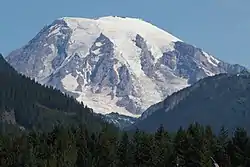 From Packwood, Mount Rainier and Butter Creek Canyon dominate the view to the north. | |
 Location of Packwood in Lewis County, WA | |
| Coordinates: 46°36′14″N 121°40′40″W | |
| Country | United States |
| State | Washington |
| County | Lewis |
| Area | |
| • Total | 1.00 sq mi (2.58 km2) |
| • Land | 1.00 sq mi (2.58 km2) |
| • Water | 0.0 sq mi (0.0 km2) |
| Elevation | 1,053 ft (321 m) |
| Population | |
| • Total | 319 |
| • Density | 343/sq mi (132.4/km2) |
| Time zone | UTC−8 (PST) |
| • Summer (DST) | UTC−7 (PDT) |
| ZIP code | 98361 |
| Area code | 360 |
| GNIS feature ID | 1524132[2] |
| FIPS code | 53-52600 |
Packwood was originally established as Sulphur Springs. Shortly thereafter, it was renamed to Lewis, in honor of Meriwether Lewis, but was finally renamed to Packwood, in honor of William Packwood due to the US Postal Service confusing the town with Fort Lewis.
History
The name "Packwood", used for the town, a mountain pass, and a lake, honors William Packwood, a Virginian pioneer and explorer of Oregon and Washington.[3] Packwood and James Longmire were tasked by the Washington Territorial Legislature to chart a low pass over the Cascade Range, this necessitated by the deaths of several delegates in their journey to the first legislative session. As a mark of their successes in this venture, the charted pass - called the Packwood Saddle - is still unused by any road, trail, or other conveyance to pass between the east and west sides of the Cascades.
Geography
Packwood is located at 46°36′14″N 121°40′40″W (46.6040008, -121.6778664),[4] at the intersection of US Highway 12 and Gifford Pinchot National Forest Road 52 (Skate Creek Road). It is located between Mount Rainier National Park to the north and Mt. St. Helens National Volcanic Monument to the south. The Tatoosh Wilderness, Goat Rocks Wilderness, and William O. Douglas Wilderness are to the north, southeast, and northeast respectively, with the Gifford Pinchot National Forest as a buffer in all directions. Packwood is located in the upper Cowlitz River valley, just downstream of the confluence of the Muddy and Clear forks of the Cowlitz. The White Pass Ski Area and crest of the Cascade Range demark the eastern edge of the Packwood area, the town of Randle the west, and large expanses of forest, wilderness, and parkland the north and south.
According to the U.S. Census Bureau, the Packwood CDP has an area of 1.0 square mile (2.6 km2), all of it recorded as land.[5] Surrounding lands, including the residential communities of High Valley and Timberline, contribute to an approximate population of 1,330 for the greater Packwood area.
Climate
According to the Köppen Climate Classification system, Packwood has a warm-summer Mediterranean climate, abbreviated "Csb" on climate maps.[6]
| Climate data for Packwood | |||||||||||||
|---|---|---|---|---|---|---|---|---|---|---|---|---|---|
| Month | Jan | Feb | Mar | Apr | May | Jun | Jul | Aug | Sep | Oct | Nov | Dec | Year |
| Record high °F (°C) | 67 (19) |
77 (25) |
85 (29) |
90 (32) |
102 (39) |
104 (40) |
108 (42) |
105 (41) |
105 (41) |
97 (36) |
75 (24) |
63 (17) |
108 (42) |
| Average high °F (°C) | 42.9 (6.1) |
48.1 (8.9) |
52.6 (11.4) |
59 (15) |
66.3 (19.1) |
71.6 (22.0) |
79 (26) |
79.1 (26.2) |
73.9 (23.3) |
61.9 (16.6) |
48.4 (9.1) |
42.3 (5.7) |
60.4 (15.8) |
| Average low °F (°C) | 29.3 (−1.5) |
30.5 (−0.8) |
32.8 (0.4) |
36.5 (2.5) |
41.8 (5.4) |
47.4 (8.6) |
51 (11) |
50.7 (10.4) |
44.7 (7.1) |
38.5 (3.6) |
33.3 (0.7) |
29.8 (−1.2) |
38.9 (3.8) |
| Record low °F (°C) | −9 (−23) |
−2 (−19) |
2 (−17) |
20 (−7) |
20 (−7) |
27 (−3) |
28 (−2) |
29 (−2) |
23 (−5) |
17 (−8) |
−3 (−19) |
−8 (−22) |
−9 (−23) |
| Average precipitation inches (mm) | 9.01 (229) |
6 (150) |
5.31 (135) |
3.39 (86) |
2.54 (65) |
2.08 (53) |
0.72 (18) |
1.06 (27) |
2.24 (57) |
4.88 (124) |
8.87 (225) |
9.05 (230) |
55.14 (1,401) |
| Average snowfall inches (cm) | 11.8 (30) |
4.7 (12) |
2.8 (7.1) |
0.3 (0.76) |
0 (0) |
0 (0) |
0 (0) |
0 (0) |
0 (0) |
0 (0) |
1.9 (4.8) |
6.4 (16) |
27.9 (71) |
| Average precipitation days (≥ 0.01 inch) | 17 | 14 | 16 | 14 | 12 | 10 | 4 | 5 | 8 | 13 | 17 | 17 | 147 |
| Source: [7] | |||||||||||||
Economy
The town of Packwood has historically relied on the forest products industry as an economic engine, supplemented by government employment (via the National Forest and Park Services) and seasonal tourism. In the late 1990s, the Forest Service began consolidation of many ranger stations, with the result that Forest Service jobs moved to the town of Randle and the new Cowlitz Valley Ranger Station. Shortly thereafter, several factors, including the Asian financial crisis, decreased logging on federal lands, and depression in lumber prices, brought the closing of the Packwood Lumber Mill. Due to the limited economic opportunity, the town's housing consists heavily of summer housing for snowbirds, retirement homes, and vacation cabins. The influx of retirees and determination of long-time locals has led to a recent civic revival in the town, however. Several local organizations seek to promote the tourism opportunities of the town, improve tourist and vacation infrastructure, and plan for the long-term economic revitalization of the town. The decades-old Annual Packwood Flea Market now attracts tens of thousands during the Memorial Day and Labor Day weekends, and the recently expanded White Pass Ski Area provides a steady flow of visitors during the otherwise tourism-slow winter months. A new art gallery, along with a heritage museum housed in the old school building, are indicative of increasing diversity and economic revitalization in the area.
Government and politics
Politics
| Year | Republican | Democratic | Third parties |
|---|---|---|---|
| 2020[8] | 52.82% 103 | 45.13% 88 | 2.06% 4 |
| Year | Republican | Democratic | Third parties |
|---|---|---|---|
| 2020[9] | 56.01 387 | 41.39% 286 | 2.61% 18 |
Packwood and the surrounding Big Bottom voting district are recognized as being majority Republican and conservative, though less so in comparison to other rural areas within Lewis County.
The 2020 election included votes for candidates of the Libertarian Party in both districts.
Education
Packwood is located in the White Pass School District, which, in addition to Packwood, covers the small towns of Randle and Glenoma and the vast forested expanse in extreme eastern Lewis County, terminating at the crest of the Cascades and the border with Yakima County. In 2004, the town's school-age population dropped to the point that the local K-6 elementary school was shuttered, although the building is still used as a county sheriff's substation, a local historical museum, and for hosting other community events.
Infrastructure
Packwood is accessible year-round by private vehicle on US 12, and seasonally by SR 123 and several forest service roads. The general aviation Packwood Airport is located three blocks west of highway 12 in downtown Packwood, and L.E.W.I.S. Mountain Highway Transit provides multiple weekday public transportation to Centralia-Chehalis, including connections to Amtrak and Greyhound.[10]
The community is among 8 locations that are part of an EV installation project on the White Pass Scenic Byway. The program will stretch from the White Pass Ski Area to Chehalis and is run in partnership with Lewis County PUD, Twin Transit, state government agencies, and local community efforts. The venture began in 2023 from two grants totaling over $1.8 million.[11]
References
- 2020 Census precinct and block populations accessed through Dave's Redistricting App on 2021-08-20.
- "Packwood". Geographic Names Information System. United States Geological Survey, United States Department of the Interior.
- Meany, Edmond S. (1921). "Origin of Washington Geographic Names". The Washington Historical Quarterly. Washington University State Historical Society. XII: 65. Retrieved June 11, 2009.
- "US Gazetteer files: 2010, 2000, and 1990". United States Census Bureau. February 12, 2011. Retrieved April 23, 2011.
- "2020 U.S. Gazetteer Files –Washington". United States Census Bureau. Retrieved March 5, 2021.
- Climate Summary for Packwood, Washington
- "PACKWOOD, WASHINGTON (456262)". Western Regional Climate Center. Retrieved November 15, 2015.
- "Lewis County 2020 Election". Results.Vote.WA. Results.Vote.WA. Retrieved July 23, 2021.
- "Lewis County November 3, 2020 General Election". vote.wa.gov. Washington Secretary of State. Retrieved August 20, 2021.
- "LEWIS Mountain Highway Transit map" (PDF). White Pass Community Services Coalition.
- The Chronicle staff (March 7, 2023). "Construction Begins on U.S. Highway 12 Electric Vehicle Charging Station Network". The Chronicle (Centralia, Washington). Retrieved June 21, 2023.
External links
 Media related to Packwood, Washington at Wikimedia Commons
- Washington Deputy Dies After Hitting Elk
Municipalities and communities of Lewis County, Washington, United States | ||
|---|---|---|
| Cities | 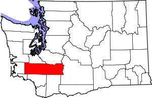 Map of Washington highlighting Lewis County | |
| Town | ||
| CDPs | ||
| Other communities | ||
| Ghost towns | ||
| Flooded towns | ||
| Indian reservation | ||
| Footnotes | ‡This populated place also has portions in an adjacent county or counties | |
| ||