Miñiques
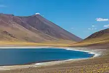
Miñiques is a massive volcanic complex containing a large number of craters, lava domes and flows, located in the Antofagasta Region of Chile. Located 21 km (13 mi) south of Volcán Chiliques and 26 km (16 mi) west of Cordón Puntas Negras, it is part of a frequently visited attraction conformed by the high plain lagoons Laguna Miscanti, Laguna Miñiques and the Cerro Miscanti volcano.
| Cerro Miñiques | |
|---|---|
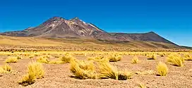
 The Miñiques volcano, seen from the Northwest. | |
| Highest point | |
| Elevation | 5,910 m (19,390 ft) |
| Coordinates | 23°49′0″S 67°46′0″W |
| Geography | |
| Location | Chile |
| Parent range | Andes |
| Geology | |
| Mountain type | Stratovolcano |
| Last eruption | Unknown |

Mountain
Miñiques consists of four overlapping volcanoes formed by lava domes and stratovolcanoes.[1] It has two summits, a lower northern summit which reaches 5,790 metres (19,000 ft) elevation and a higher southern one which is 5,910 metres (19,390 ft) high.[2] The mountain features two crater lakes, one at 5,450 metres (17,880 ft) and the other at 5,500 metres (18,000 ft) elevation[3] on the southeastern and western side of the northern summit, respectively.[2] A set of well developed moraines exists on the southern flank and may reflect glaciers advancing either from the summit area or a plateau at 4,900 metres (16,100 ft) elevation;[3] overall however glaciation on Miñiques was of limited extent[4] and the terrain of Miñiques today is dominated by periglacial processes. Laguna Miñiques lies on its northwestern foot;[2] it was separated from Laguna Miscanti by a lava flow from Miñiques.[5]
The mountain rises from a 4,100 metres (13,500 ft) high ignimbrite plateau. It is of Pleistocene age and formed by andesitic and dacitic rocks;[6] it formed during two stages in the Pliocene and Plio-Pleistocene. There is no indication of historical eruptions[1] and the volcano is classified as extinct[6] and its lava flows have been offset by faulting,[7] but activity of the Pliocene-Pleistocene volcano may have continued into the Holocene.[5] Renewed eruptions may impact International Route CH-23 as well as the surroundings of Laguna Miñiques and would mostly consist of lava flows, but are unlikely to impact populated areas.[1]
There are a number of craters, some of which contain lava domes and lava flows.[5] Stone structures and archeological sites are found on the summit and the flanks of Miñiques mountain,[8] and the church of Socaire is oriented towards the mountain.[9] The Inca associated the mountain with the god Tunupa and with lightning.[10]
See also
References
- Amigo, Álvaro R.; Bertin, Daniel U.; Orozco, Gabriel L. (2012). Peligros volcánicos de la Zona Norte de Chile (PDF) (Report). Carta geológica de Chile: Serie Geología Ambiental (in Spanish). Vol. 17. SERVICIO NACIONAL DE GEOLOGÍA Y MINERÍA. pp. 19–20. ISSN 0717-7305. Retrieved 20 August 2021.
- Schröder 1999, p. 122.
- Schröder, Hilmar (1 September 2001). "Kommentar zu den Anmerkungen von Bettina Jenny, Klaus Kammer und Bruno Messerli (Erdkunde 55, 2001)". Erdkunde (in German). 55 (3): 290. doi:10.3112/erdkunde.2001.03.07.
- Schröder 1999, p. 128.
- "Miñiques". Global Volcanism Program. Smithsonian Institution.
- Schröder 1999, p. 126.
- Tibaldi, A.; Bonali, F. L. (1 February 2018). "Contemporary recent extension and compression in the central Andes". Journal of Structural Geology. 107: 77. Bibcode:2018JSG...107...73T. doi:10.1016/j.jsg.2017.12.004. hdl:10281/187850. ISSN 0191-8141.
- Moyano, Ricardo (2011). "Sub-tropical astronomy in the southern Andes: the ceque system in Socaire, Atacama, northern Chile†". Proceedings of the International Astronomical Union. 7 (S278): 100. Bibcode:2011IAUS..278...93M. doi:10.1017/S1743921311012518. ISSN 1743-9221.
- Moyano, Ricardo (1 January 2015). "Landscape, Mountain Worship and Astronomy in Socaire". Handbook of Archaeoastronomy and Ethnoastronomy. Springer New York. pp. 921–929. Bibcode:2015hae..book..921M. doi:10.1007/978-1-4614-6141-8_92. ISBN 978-1-4614-6140-1.
- Valenzuela, América; Moyano, Ricardo (2021). "Ethnicity and Ritual in the Atacameños Andes: Water, Mountains, and Irrigation Channels in Socaire (Atacama, Chile)". Andean Foodways. The Latin American Studies Book Series. Springer International Publishing. p. 429. doi:10.1007/978-3-030-51629-1_17. ISBN 978-3-030-51629-1. S2CID 229411986.
Sources
- Schröder, Hilmar (1999). "Vergleichende Periglazialmorphologie im Sommerregengebiet der Atacama". Erdkunde (in German). 53 (2): 119–135. doi:10.3112/erdkunde.1999.02.03. ISSN 0014-0015. OCLC 998216719, 1006241123.