Chūō, Nakano, Tokyo
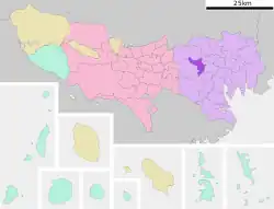
Chūō (中央) is a district of Nakano, Tokyo, Japan.
Chūō
中央 | |
|---|---|
 | |
| Country | |
| Prefecture | |
| Special ward | |
| Population (1 October 2020) | |
| • Total | 29,541[1] |
| Time zone | UTC+09:00 |
| ZIP code | 164-0011 |
| Telephone area code | 03 |
As of October 2020, the population of this district is 29,541.[1] The postal code for Chūō is 164–0011.
Geography
Chūō borders Higashinakano and Nakano in the north, Kitashinjuku to the east, Honchō to the south, and Kōenji to the west.
Education
Nakano City Board of Education (中野区教育委員会) operates public elementary and junior high schools.
Schools in Chuo:
Chuo 1-chome is zoned to Tōnoyama. 4 and 5-chome are zoned to Tōka. 3-chome is zoned to Yato Elementary School (谷戸小学校). 2-chome is divided between the zones of Tōnoyama, Tōka, Yato, and Nakano No. 1 (中野第一小学校) elementaries.[4]
Chuo 1 and 3-chome and part of 2-chome are zoned to Nakano East Junior High School (中野東中学校).[5] Chuo 4 and 5-chome are zoned to Nakano Junior High School (中野中学校).[6] Part of 2-chome is zoned to No. 2 Junior High School (第二中学校).[7]
Private:
Gallery
 Nabe-Yoko
 Sugiyama Park
 Sumitomo Nakano Sakaue Building
 Nakano Sakaue Sun Bright Twin Building
References
- "2020年住民基本台帳による人口". 中野区. Retrieved 4 November 2020.
- "TONOYAMA Elementary School". TONOYAMA Elementary School NAKANO. Retrieved 5 November 2020.
- "中野区立桃花小学校". 中野区立桃花小学校. Retrieved 5 November 2020.
- "中野区中央の通学区域". Nakano City. Retrieved 2022-10-24.
- "中野東中学校の通学区域". Nakano City. Retrieved 2022-10-24.
- "中野中学校の通学区域". Nakano City. Retrieved 2022-10-24.
- "第二中学校の通学区域". Nakano City. Retrieved 2022-10-24.
- "堀越高等学校". Horikoshigakuen. Retrieved 5 November 2020.
