Chappel & Wakes Colne railway station
Chappel & Wakes Colne railway station is on the Gainsborough Line, a branch to Sudbury off the Great Eastern Main Line, in the East of England, serving the village of Wakes Colne and the neighbouring Chappel. It is 3 miles 49 chains (5.81 km) down the line from Marks Tey and 50 miles 18 chains (80.83 km) measured from London Liverpool Street. It is situated between Marks Tey and Bures. Its three-letter station code is CWC. Platform 1 has an operational length for five-coach trains.[1] Platforms 2 and 3 are used by the East Anglian Railway Museum.[2]
Chappel & Wakes Colne | |
|---|---|
 Chappel & Wakes Colne railway station in 2011 | |
| General information | |
| Location | Wakes Colne, Colchester England |
| Grid reference | TL897288 |
| Managed by | Greater Anglia |
| Platforms | 1 |
| Other information | |
| Station code | CWC |
| Classification | DfT category F2 |
| Key dates | |
| 2 July 1849 | Opened as Chappel |
| 1 October 1914 | Renamed Chappel & Wakes Colne |
| Passengers | |
| 2017/18 | |
| 2018/19 | |
| 2019/20 | |
| 2020/21 | |
| 2021/22 | |
| Notes | |
Passenger statistics from the Office of Rail and Road | |
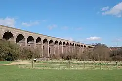
The station is currently operated by Greater Anglia, who also operate all trains serving it, as part of the East Anglia franchise. It has one platform as the line is single-track. It is also home to the East Anglian Railway Museum which has the former London-bound platform, a running line, the original station buildings and all of the land and facilities on the east side of the line. Just to the south of the station the line runs over the Chappel viaduct.

Chappel & Wakes Colne is unstaffed but has a self-service ticket machine. The platform buildings, on the station's west side, are restored to 1950s style but are part of the museum, and entered from ground-floor level.
History
The station opened with the opening of the line from Marks Tey to Sudbury as part of the Stour Valley Railway on 2 July 1849, with the name Chappel; it was renamed Chappel and Wakes Colne on 1 October 1914.[3]
The 1861 census shows Samuel Hamblin as the resident station-master. He appears to have fallen foul of the railway authorities at some stage as he is shown working in Poplar as an engine driver in the 1871 census. The 1871 census records 29-year-old Alfred H. Bryant as the resident station-master. The 1881 census shows 45-year-old George William Grand as the station-master, a position he held until at least 1891.
Chappel Viaduct
Sitting just to the south of the station is the outstanding feature on the line, the 1,066-foot (325 m) long viaduct consisting of 32 arches each having a 30-foot span and standing 75 feet above the valley floor. Built at a cost of £32,000 it contains seven million bricks. The 1851 census records that a foreman bricklayer and several labourers were living in huts adjacent to the viaduct. The vast majority of the bricks had been manufactured on-site using local clay.
Services
The typical off-peak service is one train per hour in each direction, with frequency increased slightly during the peak.[4] The last train of the day continues to Colchester.
| Operator | Route | Rolling stock | Frequency |
|---|---|---|---|
| Greater Anglia | Sudbury - Bures - Chappel & Wakes Colne - Marks Tey | Class 755 | 1x per hour |
In popular culture
This station was used as a filming location in two scenes for the 2013 film The Numbers Station, starring John Cusack.
References
- Brailsford, Martyn (2016). Railway Track Diagrams Volume 2 Eastern. Frome: TRACKmaps. p. 5. ISBN 978-0-9549866-8-1.
- Steam trains around Essex 6 March 2019 www.essexlive.news, accessed 7 November 2020
- Butt, R.V.J. (1995). The Directory of Railway Stations. Yeovil: Patrick Stephens Ltd. p. 57. ISBN 1-85260-508-1. R508.
- Table 10 National Rail timetable, May 2016
External links
- Train times and station information for Chappel & Wakes Colne railway station from National Rail
- History page at Subterranea Britannica
- East Anglian Railway Museum website
- Chappel Parish Council website
- Website of the village and railway
- Chappel and Wakes Colne station on navigable 1946 O. S. map
| Preceding station | Following station | |||
|---|---|---|---|---|
| Marks Tey | Greater Anglia Gainsborough Line |
Bures | ||
| Disused railways | ||||
| Terminus | Colne Valley and Halstead Railway | White Colne Line and station closed | ||