Châu Đốc
Châu Đốc is a city in An Giang Province, bordering Cambodia, in the Mekong Delta region of Vietnam. As of 2013, the city had a population of 157,298, and cover an area of 105.29 square kilometres (40.65 sq mi).[1]
Châu Đốc
Thành phố Châu Đốc | |
|---|---|
| Châu Đốc City | |
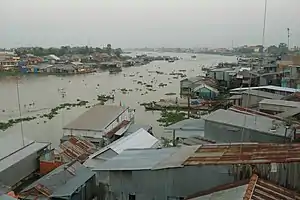 Panoramic view of Châu Đốc. | |
 Châu Đốc Location in Vietnam | |
| Coordinates: 10°42′N 105°7′E | |
| Country | |
| Province | An Giang Province |
| Area | |
| • Total | 40.65 sq mi (105.29 km2) |
| Population (2018) | |
| • Total | 161,547 |
| • Density | 4,000/sq mi (1,500/km2) |
| Time zone | UTC+7 (ICT) |
The city is located by the Hậu River (a branch of the Mekong River flowing through Vietnamese territory) and Vĩnh Tế Canal. Châu Đốc is situated 250 kilometres (160 mi) west of Ho Chi Minh City. It takes about six hours to travel by bus from Ho Chi Minh City.
History

The territory became Vietnam's around the 17th century. The town is near the picturesque Sam Mountain where the Sam Mountain Lady (Vietnamese: Bà Chúa Xứ Núi Sam) is worshipped. The Sam Mount Lady Ceremony is held every April of lunar calendar (May) every year.
Floods caused devastation in the region, the one in late 1938 saw 125,000 hectares of ruined rice land due to floods.[2]
In 1957, the town was the site of the Châu Đốc massacre.[3]
Climate
Châu Đốc has a tropical savanna climate (Köppen Aw) with a long though not extreme wet season from April to November and a dry season from December to March.
| Climate data for Châu Đốc | |||||||||||||
|---|---|---|---|---|---|---|---|---|---|---|---|---|---|
| Month | Jan | Feb | Mar | Apr | May | Jun | Jul | Aug | Sep | Oct | Nov | Dec | Year |
| Record high °C (°F) | 34.9 (94.8) |
36.4 (97.5) |
37.7 (99.9) |
38.6 (101.5) |
37.5 (99.5) |
36.5 (97.7) |
35.4 (95.7) |
35.1 (95.2) |
35.5 (95.9) |
34.0 (93.2) |
33.9 (93.0) |
34.2 (93.6) |
38.6 (101.5) |
| Average high °C (°F) | 30.6 (87.1) |
31.7 (89.1) |
33.5 (92.3) |
34.7 (94.5) |
33.6 (92.5) |
32.5 (90.5) |
32.0 (89.6) |
31.7 (89.1) |
31.3 (88.3) |
31.9 (89.4) |
30.9 (87.6) |
30.1 (86.2) |
32.0 (89.6) |
| Daily mean °C (°F) | 25.8 (78.4) |
26.2 (79.2) |
27.6 (81.7) |
28.8 (83.8) |
28.5 (83.3) |
27.9 (82.2) |
27.5 (81.5) |
27.7 (81.9) |
27.7 (81.9) |
27.5 (81.5) |
27.3 (81.1) |
26.1 (79.0) |
27.4 (81.3) |
| Average low °C (°F) | 22.6 (72.7) |
22.6 (72.7) |
23.7 (74.7) |
25.2 (77.4) |
25.7 (78.3) |
25.3 (77.5) |
25.0 (77.0) |
25.3 (77.5) |
25.4 (77.7) |
25.2 (77.4) |
24.8 (76.6) |
23.1 (73.6) |
24.5 (76.1) |
| Record low °C (°F) | 17.0 (62.6) |
17.6 (63.7) |
17.5 (63.5) |
21.0 (69.8) |
21.9 (71.4) |
20.0 (68.0) |
21.1 (70.0) |
21.0 (69.8) |
21.2 (70.2) |
22.2 (72.0) |
19.4 (66.9) |
16.8 (62.2) |
16.8 (62.2) |
| Average precipitation mm (inches) | 8.1 (0.32) |
4.2 (0.17) |
23.2 (0.91) |
94.2 (3.71) |
165.5 (6.52) |
125.9 (4.96) |
155.7 (6.13) |
179.3 (7.06) |
184.1 (7.25) |
269.0 (10.59) |
149.4 (5.88) |
46.5 (1.83) |
1,412.6 (55.61) |
| Average rainy days | 2.1 | 1.0 | 2.8 | 7.9 | 15.4 | 16.9 | 18.8 | 18.7 | 19.5 | 20.7 | 13.5 | 5.1 | 142.3 |
| Average relative humidity (%) | 78.4 | 79.4 | 77.2 | 77.1 | 81.9 | 83.3 | 83.4 | 82.8 | 83.7 | 83.2 | 80.0 | 78.0 | 80.7 |
| Mean monthly sunshine hours | 240.0 | 235.1 | 254.4 | 229.6 | 210.1 | 178.0 | 172.3 | 171.5 | 168.2 | 185.0 | 203.7 | 223.1 | 2,469.5 |
| Source: Vietnam Institute for Building Science and Technology[4] | |||||||||||||
Landmarks
The Phước Điền Temple is located in Châu Đốc. It is an official historic monument of Vietnam. The Victoria Hotel is the only notable hotel in the area. There are also many hotels in the center near the main market area, where you can get good value for money accommodation. There are other hotels that are situated near Nui Sam. There are a couple of new hotels on the road to Sam Mountain. A worthwhile option to consider is a night (or two) in one of the floating hotels (there are 2, one reachable via footbridge, the other via boat).
Sam Mountain, being the highest mountain in Mekong Delta (284 m),[5] is a famous mountain in Châu Đốc, about 7 kilometres (4.3 mi) from the city.
Tây An Temple, dating from 1847, is near the city.
Population
Vietnamese, Cham, and Khmer live together in harmony. The three main religions in this region are Mahayana Buddhism (Kinh/Vietnamese); Theravada Buddhism (Khmer), and Sunni Islam (Chams). The total population is around 120,000 with a vast majority of Kinh (Viet).[6]
As of 2003, the district had a population of 112,155.[7] The district covers an area of 100 square kilometres (39 sq mi).[7]
In July 2013, the city had a population of 157,298.
Economy
Châu Đốc is famous for its variety of fish sauces (nước mắm) and mainly "mắm tai", a kind of anchovy. The local economy is based on the culture of basa catfish export and on tourism. The town is a busy trading center due to its border position with Cambodia. Local people also buy, sell, and exchange goods on boats on the river. It's called a floating market.
Administrative subdivisions
Châu Đốc is subdivided into 7 commune-level subdivisions, including the wards of Châu Phú A, Châu Phú B, Núi Sam, Vĩnh Mỹ, Vĩnh Nguơn and the rural communes of Vĩnh Châu and Vĩnh Tế.
Gallery
 View from Sam Mountain
 Houses on Bassac River
 Floating village
 Market
 City street
 City street
 The honous paper in Châu Phú temple
References
- Nghị quyết số 86/NQ-CP của Chính phủ : Về việc thành lập phường Vĩnh Ngươn thuộc thị xã Châu Đốc và thành lập thành phố Châu Đốc thuộc tỉnh An Giang upgrade to city level on July 19, 2013
- Kiernan, Ben (2017-02-10). Viet Nam: A History from Earliest Times to the Present. Oxford University Press. ISBN 978-0-19-062730-0.
- "Supernatural Awards said promised Viet Nam people for following red dogma". Times-News. Hendersonville, North Carolina. August 17, 1957. Retrieved May 26, 2010.
- "Vietnam Institute for Building Science and Technology" (PDF).
- "Trang chủ An Giang".
- "Thị Xã Châu Đốc". Archived from the original on 2013-12-10.
- "Districts of Vietnam". Statoids. Retrieved March 13, 2009.
