Chernihiv Governorate
Chernihiv Governorate (Ukrainian: Чернігівська губернія, romanized: Chernihivska huberniia) was an administrative territorial subdivision of the Ukrainian State and the Ukrainian SSR, existing from 1918 to 1925. It was inherited from the Russian system of territorial subdivisions that existed prior to World War I. Specifically, the Chernigov Governorate (Russian: Черниговская губерния; translit.: Chernigovskaya guberniya; Ukrainian: Чернігівська губернія, romanized: Chernihivska huberniia), also known as the Government of Chernigov, was a guberniya in the historical Left-bank Ukraine region of the Russian Empire, which was officially created in 1802 from the Malorossiya Governorate with an administrative centre of Chernihiv. The Little Russian Governorate was transformed into the General Government of Little Russia and consisted of Chernigov Governorate, Poltava Governorate, and later Kharkov Governorate.
| Chernihiv Governorate Чернігівська губернія | |||||||||||||||||||
|---|---|---|---|---|---|---|---|---|---|---|---|---|---|---|---|---|---|---|---|
| Governorate of Ukrainian State and Ukrainian SSR | |||||||||||||||||||
| 1918–1925 | |||||||||||||||||||
 Chernihiv Governorate | |||||||||||||||||||
| Capital | Chernihiv | ||||||||||||||||||
| Area | |||||||||||||||||||
• (1897) | 52,396 km2 (20,230 sq mi) | ||||||||||||||||||
| Population | |||||||||||||||||||
• (1897) | 2298000 | ||||||||||||||||||
| History | |||||||||||||||||||
| History | |||||||||||||||||||
• Established | 27 February 1918 | ||||||||||||||||||
• Disestablished | 1 August 1925 | ||||||||||||||||||
| Political subdivisions | counties: 18 (1918–1919) 11 (1919–1923) okruhas: 5 (1923–1925) | ||||||||||||||||||
| |||||||||||||||||||
| Today part of | Chernihiv Oblast Kyiv Oblast Bryansk Oblast Kursk Oblast Gomel Region | ||||||||||||||||||
| Chernigov Governorate Черниговская губернія | |||||||||
|---|---|---|---|---|---|---|---|---|---|
| Governorate of Russian Empire (1802–1917), and Ukrainian People's Republic (1917–1918) | |||||||||
| 1802–1918 | |||||||||
 Coat of arms
| |||||||||
.svg.png.webp) Chernigov Governorate within the Russian Empire | |||||||||
| Capital | Chernigov (Chernihiv) | ||||||||
| Area | |||||||||
• (1897) | 52,396 km2 (20,230 sq mi) | ||||||||
| Population | |||||||||
• (1897) | 2298000 | ||||||||
| History | |||||||||
| History | |||||||||
• Established | 27 February 1802 | ||||||||
• Disestablished | 1 August 1918 | ||||||||
| Political subdivisions | uezds: 15 | ||||||||
| |||||||||
| Today part of | Chernihiv Oblast Kyiv Oblast Bryansk Oblast | ||||||||
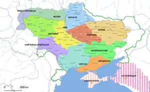
Chernigov Governorate borders are roughly consistent with the modern Chernihiv Oblast, but also included a large section of Sumy Oblast and smaller sections of the Kyiv Oblast of Ukraine, in addition to most of the Bryansk Oblast, Russia.
Administrative division
When part of the Russian Empire, the governorate consisted of 15 uyezds (their administrative centres in brackets):
- Borznyansky Uyezd (Borzna)
- Glukhovsky Uezd (Hlukhiv)
- Gorodnyansky Uyezd (Gorodnya/Horodnia)
- Kozeletsky Uyezd (Kozelets)
- Konotopsky Uyezd (Konotop)
- Krolevetsky Uyezd (Krolevets)
- Mglinsky Uyezd (Mglin)
- Nezhinsky Uyezd (Nezhin/Nizhyn)
- Novgorod-Seversky Uyezd (Novgorod-Seversky/Novhorod-Siverskyi)
- Novozybkovsky Uyezd (Novozybkov)
- Ostyorsky Uyezd (Ostyor/Oster)
- Sosnitsky Uyezd (Sosnitsa/Sosnytsia)
- Starodubsky Uyezd (Starodub)
- Surazhsky Uyezd (Surazh)
- Chernigovsky Uyezd (Chernigov/Chernihiv)[1]
The Chernigov Governorate covered a total area of 52,396 km², and had a population of 2,298,000, according to the 1897 Russian Empire census. In 1914, the population was 2,340,000. In 1918 it became part of Ukraine and transformed into Chernihiv Governorate.
As part of the Ukrainian State and the Ukrainian SSR, the governorate consisted of 18 counties (povits):
- Borzna County
- Hlukhiv County
- Horodnya County
- Homel County (added from the Mogilev Governorate)
- Kozelets County
- Konotop County
- Krolevets County
- Nizhin County
- Novhorod-Siversky County
- Oster County
- Putyvl County (added from the Kursk Governorate)
- Rylsk County (added from the Kursk Governorate)
- Sosnytsia County
- Chernihiv County
- Mhlyn County
- Novozybkiv County
- Starodub County
- Surazh County
In 1919, the northern Mhlyn, Novozybkiv, Starodub, and Surazh counties, with their mixed Ukrainian–Belarusian–Russian population, were transferred from Ukraine to the newly established Gomel Governorate of the Russian republic.[2]
In 1925, the governorate’s territory was redistributed among Hlukhiv, Konotop, Nizhyn, and Chernihiv districts (okruhas).[2]
Principal cities
At the times of the Russian Census of 1897:
- Nezhin – 32,113 (Ukrainian – 21,733, Jewish – 7,578, Russian – 2,366)
- Chernigov – 27,716 (Ukrainian – 10,085, Jewish – 8,780, Russian – 7,985)
- Konotop – 18,770 (Ukrainian – 10,290, Jewish – 4,415, Russian – 3,565)
- Novozybkov – 15,362 (Russian – 11,055, Jewish – 3,787, Belarusian – 303)
- Hlukhiv – 14,828 (Ukrainian – 8,621, Jewish – 3,837, Russian – 2,217)
- Borzna – 12,526 (Ukrainian – 10,846, Jewish – 1,515, Russian – 109)
- Starodub – 12,381 (Russian – 7,255, Jewish – 4,897, Ukrainian – 133)
- Krolevets – 10,384 (Ukrainian – 8,328, Jewish – 1,815, Russian – 209)
- Berezna – 9,922 (Ukrainian – 8,349, Jewish – 1,354, Russian – 144)
- Novgorod-Seversky – 9,182 (Ukrainian – 4,884, Jewish – 2,941, Russian – 1,296)
- Mglin – 7,640 (Russian – 4,840, Jewish – 2,675, Belarusian – 75)
- Sosnytsia – 7,087 (Ukrainian – 5,068, Jewish – 1,840, Russian – 158)
- Korop – 6,262 (Ukrainian – 5,309, Jewish – 865, Russian – 77)
- Oster – 5,370 (Ukrainian – 3,229, Jewish – 1,596, Russian – 399)
- Kozelets – 5,141 (Ukrainian – 2,834, Jewish – 1,632, Russian – 468)
- Pogar – 4,965 (Russian – 3,800, Jewish – 1,159, Germans – 6)
- Gorodnya – 4,310 (Ukrainian – 2,349, Jewish – 1,248, Russian – 604)
- Surazh – 4,006 (Jewish – 2,400, Belarusian – 978, Russian – 559)
- Novoye Mesto – 1,488 (Russian – 1,421, Jewish – 67)
Language
At the time of the Imperial census of 1897.[3] In bold are languages spoken by more people than the state language.
| Language | Number | percentage (%) | males | females |
|---|---|---|---|---|
| Ukrainian | 1,526,072 | 66.41 | 747,721 | 778,351 |
| Russian | 495,963 | 21.58 | 236,842 | 259,121 |
| Belarusian | 151,465 | 6.59 | 73,691 | 77,774 |
| Yiddish | 113,787 | 4.95 | 54,724 | 59,063 |
| German | 5,306 | 0.23 | 2,664 | 2,642 |
| Polish | 3,302 | 0.14 | 1,775 | 1,527 |
| Persons that didn't name their native language | 74 | >0.01 | 32 | 42 |
| Other[4] | 1,885 | >0.01 | 1,247 | 638 |
| Total | 2,297,854 | 100 | 1,118,696 | 1,179,158 |
Notable people
- Elizaveta I. Gnevusheva (1916-1994), historian, orientalist, university lecturer, publicist
References
- Генеральная карта Черниговской губерніи Съ показаніемъ почтовыхъ и большихъ проъзжихъ дорогъ, станціи и разстоянія между оными верстъ – Ст. Петербургъ, 1829. (in Russian) (Page title read as: "General map of the Chernihiv province. St. Petersburg, 1829.")
- "Chernihiv gubernia". www.encyclopediaofukraine.com. Retrieved 28 May 2020.
- Language Statistics of 1897 Archived 22 June 2011 at the Wayback Machine (in Russian)
- Languages, number of speakers which in all gubernia were less than 1000
External links
- Chernihiv Governorate. Encyclopedia of Ukraine.
- Chernigov Guberniya – Article in Brockhaus and Efron Encyclopedic Dictionary (in Russian)
- Chernigov Governorate – Historical coat of arms (in Ukrainian and English)