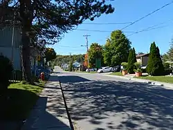
Chertsey, Quebec
Chertsey is a municipality in the regional county municipality of Matawinie in Quebec, Canada, located in the administrative region of Lanaudière.
Chertsey | |
|---|---|
 | |
 Coat of arms | |
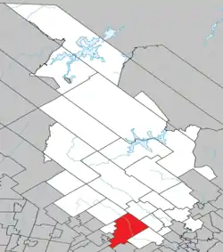 Location within Matawinie RCM | |
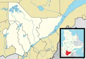 Chertsey Location in central Quebec | |
| Coordinates: 46°10′N 73°55′W[1] | |
| Country | Canada |
| Province | Quebec |
| Region | Lanaudière |
| RCM | Matawinie |
| Constituted | November 13, 1991 |
| Government | |
| • Mayor | Jocelyn Gravel |
| • Federal riding | Joliette |
| • Prov. riding | Rousseau |
| Area | |
| • Total | 301.70 km2 (116.49 sq mi) |
| • Land | 286.05 km2 (110.44 sq mi) |
| Population | |
| • Total | 5,295 |
| • Density | 18.5/km2 (48/sq mi) |
| • Pop 2016-2021 | |
| • Dwellings | 4,255 |
| Time zone | UTC−5 (EST) |
| • Summer (DST) | UTC−4 (EDT) |
| Postal code(s) | |
| Area code(s) | 450 and 579 |
| Highways | |
| Website | chertsey |
The diocesan shrine Mary Queen of Hearts (Marie-Reine-des-Coeurs) is in Chertsey.[4]
Lake Beaulac, the lake with the highest elevation in Lanaudière, was annexed by the municipality in 1991.
Demographics
Population
| Year | Pop. | ±% |
|---|---|---|
| 1991 | 2,908 | — |
| 1996 | 3,853 | +32.5% |
| 2001 | 4,112 | +6.7% |
| 2006 | 5,006 | +21.7% |
| 2011 | 4,836 | −3.4% |
| 2016 | 4,696 | −2.9% |
| 2021 | 5,295 | +12.8% |
Private dwellings occupied by usual residents: 2,720 (total dwellings: 4,255)
Language
Mother tongue:[6]
- English as first language: 3.1%
- French as first language: 92.6%
- English and French as first language: 1.8%
- Other as first language: 2.2%
Education
Commission scolaire des Samares operates Francophone public schools:
- École de Saint-Théodore-de-Chertsey[7]
Sir Wilfrid Laurier School Board operates Anglophone public schools:
- Rawdon Elementary School in Rawdon[8]
- Joliette High School in Joliette[9]
See also
References
- "Reference number 269410 in Banque de noms de lieux du Québec". toponymie.gouv.qc.ca (in French). Commission de toponymie du Québec.
- "Geographic code 62047 in the official Répertoire des municipalités". www.mamh.gouv.qc.ca (in French). Ministère des Affaires municipales et de l'Habitation.
- Statistics Canada 2021 Census - Chertsey census profile
- Sanctuaire diocésain Marie-Reine-des-Coeurs
- Statistics Canada: 1996, 2001, 2006, 2011, 2016, 2021 census
- Statistics Canada 2021 Census - Chertsey community profile
- "de Saint-Théodore-de-Chertsey Archived 2017-09-23 at the Wayback Machine." Commission scolaire des Samares. Retrieved on September 23, 2017.
- "Rawdon Elementary" Zone Map. Sir Wilfrid Laurier School Board. Retrieved on September 17, 2017.
- "Joliette High School Zone Sec 1-5." Sir Wilfrid Laurier School Board. Retrieved on September 5, 2017.
External links
 Media related to Chertsey, Quebec at Wikimedia Commons
- (in French) Municipalité de Chertsey
Adjacent Municipal Subdivisions | |
|---|---|
| Municipalities | |
|---|---|
| Parishes | |
| Unorganized Territories | |
| |
This article is issued from Wikipedia. The text is licensed under Creative Commons - Attribution - Sharealike. Additional terms may apply for the media files.