Chhagalnaiya
Chhagalnaiya (Bengali: ছাগলনাইয়া) is a town in Feni district of Chittagong Division, Bangladesh. The town is the administrative headquarters and urban centre of Chhagalnaiya Upazila.The urban area of Chhagalnaiya is the biggest in Chhagalnaiya Upazila and 2nd most populous in Feni district. Chhagalnaiya is 14.6 km away[2] from the district headquarters, Feni city while the distance from the Divisional Headquarters, Chittagong is 96.6 km.[3] The nearest airport from Chhagalnaiya town is Shah Amanat International Airport.
Chhagalnaiya
ছাগলনাইয়া Sagarnaiya | |
|---|---|
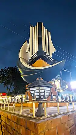
 A sculpture situated at the Zero point of Chhagalnaiya town | |
 Chhagalnaiya location of Chhagalnaiya town in Bangladesh | |
| Coordinates: 23.039483°N 91.514628°E | |
| Country | |
| Division | Chittagong |
| District | Feni |
| Upazila | Chhagalnaiya |
| Upazila headquarter | 1 October 1983 |
| Municipality | 3 June 2002 |
| Government | |
| • Type | Mayor–Council |
| • Body | Chhagalnaiya Municipality |
| • Paura Mayor | Mohammad Mostafa[1] |
| Area | |
| • Total | 25.3 km2 (9.8 sq mi) |
| Population (2011) | |
| • Total | 48,243 |
| • Density | 1,900/km2 (4,900/sq mi) |
| Time zone | UTC+6 (Bangladesh Time) |
| National Dialing Code | +880 |
History
Chhagalnaiya is also the name for eponymous upazila in Feni district of Bangladesh. It is believed that the name of the area changed from Sagarnaiya (whom the sea bathes or bathes) to Chagalnaiya, as a result of mistakenly writing L instead of R in official documents during the British rule. Due to its convenient geographical location and proximity to the border, the place has historically played an important role - especially during the liberation war of Bangladesh. Goats have nothing to do with this region, on the other hand it is a region created by the freezing of the sea char and Naiya means sailor, it means Sagarnaiya is a sea sailor. Chhagalnaiya is actually a derivative of Sagarnaiya or sea-sailor as many people from this region used to go to the sea to earn their bread.
Climate
| ||||||||||||||||||||||||||||||||||||||||||||||||||||||||||||||||||||||||||||||||||||||||||||||||||||||||||||||||||||||||||||
Geography
Chhagalnaiya is located at 23.0361°N 91.5194°E. It has an average elevation of 8 metres.
Demography
According to 2011 Bangladesh census, Chhgalnaiya town has a population of about 48,243 of which 23,857 are male and 24,386 are female. [5]
Administration
The town is administered by a local governing body called Chhagalnaiya Municipality or Chhagalnaiya Paurashava which has divided the town into 9 wards. The town occupies an area of 27.04 km2 of which municipality governs an area of 25.2 5 km2.
Transport
The town is the road transport hub of the upazila. To the west it is connected by zilla road Z1031 to Feni, about 14 kilometres (8.7 mi) away. Z1035 runs north 23 kilometres (14 mi) to Parshuram. Z1032 runs south 11 kilometres (6.8 mi) to Muhuriganj, where it connects to the Dhaka-Chittagong Highway.[6]
Education
The literacy rate of the town is 62.7%. Some of the notable educational institution of the town are:
- Chhagalnaiya government college
- Chhagalnaiya academy
- Chhagalnaiya Govt. Pilot high school
- Chhagalnaiya Pilot girls high School
- Moulovi Samsul Karim College
- Radhanagar High School
- Karaiya High School
See also
References
- "Mayor of Chhagalnaiya Paurashava". News24.com. Archived from the original on October 1, 2020. Retrieved 2020-03-16.
- "Distance from Feni to Chhagalnaiya". distancesto.com. Retrieved 2020-03-16.
- "Distance from Chittagong to Chhagalnaiya". distancesto.com. Retrieved 2020-03-16.
- "NASA Earth Observations: Land Cover Classification". NASA/MODIS.
- "Chapter:5,Urban Centers in Bangladesh". Population & Housing Census-2011 (PDF) (Report). National report. Vol. 3. Bangladesh Bureau of Statistics. p. 192. ISBN 978-984-519-036-7. Retrieved 2019-12-01.
- "RHD Road Network, Comilla Zone" (PDF). Roads and Highways Department. May 2005. Archived from the original (PDF) on 6 December 2019. Retrieved 6 December 2019.