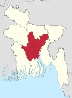
Chittagong Division
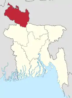
Chittagong Division, officially known as Chattogram Division, is geographically the largest of the eight administrative divisions of Bangladesh. It covers the south-easternmost areas of the country, with a total area of 34,529.97 km2 (13,332.10 sq mi) and a population at the 2022 census of 33,202,326. The administrative division includes mainland Chittagong District, neighbouring districts and the Chittagong Hill Tracts.
Chittagong Division
চট্টগ্রাম বিভাগ | |
|---|---|
| Chattogram Division | |
  | |
| Coordinates: 22°55′N 91°30′E | |
| Country | |
| Established | 1829 |
| Capital | Chittagong |
| Government | |
| • Body | Government of Bangladesh |
| • Divisional Commissioner | Md. Aminur Rahman, NDC[1] |
| • Parliamentary constituency | Jatiya Sangsad (58 seats) |
| Area | |
| • Total | 34,529.97 km2 (13,332.10 sq mi) |
| Population (2022)[2] | |
| • Total | 33,202,326 |
| • Density | 960/km2 (2,500/sq mi) |
| Time zone | UTC+6 (BST) |
| ISO 3166 code | BD-B |
| Notable sport teams | Chattogram Challengers, Chittagong Division, Chittagong Abahani |
| Website | www |
Chittagong Division is home to Cox's Bazar, the longest natural sea beach in the world;[3][4] as well as St. Martin's Island, Bangladesh's sole coral reef.
History
The Chittagong Division was established in 1829 to serve as an administrative headquarters for five of Bengal's easternmost districts, with the Chittagong District serving as its headquarters.[5] During the East Pakistan period, the division's Tippera district was renamed to Comilla District in 1960.
In 1984, fifteen districts were created by separating and reducing the original five districts of Chittagong, Comilla, Hill Tracts, Noakhali and Sylhet:
- The Chittagong District was divided into two districts; Chittagong and Cox's Bazar District
- The Comilla District was split into three districts; Comilla, Brahmanbaria and Chandpur
- The Hill Tracts District was split into three districts; Bandarban, Khagrachhari and Rangamati
- The Noakhali District was divided into three districts; Noakhali, Lakshmipur and Feni
- The Sylhet District was split into four districts; Sylhet, Habiganj, Moulvibazar and Sunamganj.
Sylhet, Habiganj, Moulvibazar and Sunamganj district ceded from the Chittagong Division to join a newly-established Sylhet Division in 1995.
Administration
Chittagong Division is presently subdivided into eleven districts (zilas) and thence into 100 sub-districts (upazilas).[6] The first six districts listed below comprise the north-western portion (37.6%) of the division, while the remaining five comprise the south-eastern portion (62.4%), the two portions being separated by the lower (or Bangladeshi) stretch of the Feni River; the upland districts of Khagrachhari, Rangamati and Bandarban together comprise that area previously known as the Chittagong Hill Tracts.
| Name | Headquarters | Area (km2) | Population 1991 Census | Population 2001 Census | Population 2011 Census | Population 2022 Census[2] |
|---|---|---|---|---|---|---|
| Brahmanbaria District | Brahmanbaria | 1,881.20 | 2,141,745 | 2,398,254 | 2,840,498 | 3,306,559 |
| Comilla District | Comilla | 3,146.30 | 4,032,666 | 4,595,539 | 5,387,288 | 6,212,216 |
| Chandpur District | Chandpur | 1,645.32 | 2,032,449 | 2,271,229 | 2,416,018 | 2,635,748 |
| Lakshmipur District | Lakshmipur | 1,440.39 | 1,312,337 | 1,489,901 | 1,729,188 | 1,938,111 |
| Noakhali District | Maijdee | 3,685.87 | 2,217,134 | 2,577,244 | 3,108,083 | 3,625,252 |
| Feni District | Feni | 990.36 | 1,096,745 | 1,240,384 | 1,437,371 | 1,648,896 |
| Khagrachhari District | Khagrachhari | 2,749.16 | 342,488 | 525,664 | 613,917 | 714,119 |
| Rangamati District | Rangamati | 6,116.11 | 401,388 | 508,182 | 595,979 | 647,587 |
| Bandarban District | Bandarban | 4,479.01 | 230,569 | 298,120 | 388,335 | 481,109 |
| Chittagong District | Chittagong | 5,282.92 | 5,296,127 | 6,612,140 | 7,616,352 | 9,169,464 |
| Cox's Bazar District | Cox's Bazar | 2,491.85 | 1,419,260 | 1,773,709 | 2,289,990 | 2,823,265 |
| Total Districts | 11 | 34,529.97 | 20,552,908 | 24,290,384 | 28,423,019 | 33,202,326 |
Demographics
According to the 2022 Census of Bangladesh, Chittagong Division had 7,528,333 households and a population of 33,202,326, 33.7% of whom lived in urban areas. The population density was 979 people per km2. 90.11% were Muslims, 6.61% Hindus, 2.92% Buddhists, 0.22% Christians and 0.14% others.[2]
See also
References
- "List of Divisional Commissioners". Archived from the original on 2022-06-18. Retrieved 2022-06-20.
- Population and Housing Census 2022: Preliminary Report. Bangladesh Bureau of Statistics. August 2022. pp. 6, 9, 12, 16, 21, 27. ISBN 978-984-35-2977-0. Archived from the original on 2023-01-14. Retrieved 2023-06-08.
- Ethirajan, Anbarasan (26 December 2012). "Bangladesh's Cox's Bazar: A paradise being lost?". BBC World. Archived from the original on 14 June 2018. Retrieved 29 January 2015.
- The Europa World Year Book 2003. Taylor & Francis. 2003. p. 679. ISBN 978-1-85743-227-5.
- Webster, John Edward (1911). "History: Divisional Commissioners". Eastern Bengal and Assam District Gazetteers. Vol. 4. Noakhali. Allahabad: The Pioneer Press. p. 26.
- Ahmed Anam (2012). "Chittagong Division". In Sirajul Islam; Miah, Sajahan; Khanam, Mahfuza; Ahmed, Sabbir (eds.). Banglapedia: the National Encyclopedia of Bangladesh (Online ed.). Dhaka, Bangladesh: Banglapedia Trust, Asiatic Society of Bangladesh. ISBN 984-32-0576-6. OCLC 52727562. OL 30677644M. Retrieved 27 October 2023.
- "District Statistics 2011: Brahmanbaria" (PDF). Bangladesh Bureau of Statistics. Archived from the original (PDF) on 13 November 2014. Retrieved 25 July 2014.
- "District Statistics 2011: Comilla" (PDF). Bangladesh Bureau of Statistics. Archived from the original (PDF) on 25 April 2015. Retrieved 25 July 2014.
- "District Statistics 2011: Chandpur" (PDF). Bangladesh Bureau of Statistics. Archived from the original (PDF) on 13 November 2014. Retrieved 25 July 2014.
- "District Statistics 2011: Lakshmipur" (PDF). Bangladesh Bureau of Statistics. Archived from the original (PDF) on 13 November 2014. Retrieved 25 July 2014.
- "District Statistics 2011: Noakhali" (PDF). Bangladesh Bureau of Statistics. Archived from the original (PDF) on 26 October 2014. Retrieved 25 July 2014.
- "District Statistics 2011: Feni" (PDF). Bangladesh Bureau of Statistics. Archived from the original (PDF) on 13 November 2014. Retrieved 25 July 2014.
- "District Statistics 2011: Khagrachhari" (PDF). Bangladesh Bureau of Statistics. Archived from the original (PDF) on 13 November 2014. Retrieved 25 July 2014.
- "District Statistics 2011: Rangamati" (PDF). Bangladesh Bureau of Statistics. Archived from the original (PDF) on 13 November 2014. Retrieved 25 July 2014.
- "District Statistics 2011: Bandarban" (PDF). Bangladesh Bureau of Statistics. Archived from the original (PDF) on 13 November 2014. Retrieved 25 July 2014.
- "District Statistics 2011: Chittagong" (PDF). Bangladesh Bureau of Statistics. Archived from the original (PDF) on 13 November 2014. Retrieved 25 July 2014.
- "District Statistics 2011: Cox's Bazar" (PDF). Bangladesh Bureau of Statistics. Archived from the original (PDF) on 13 November 2014. Retrieved 25 July 2014.
External links
Places adjacent to Chittagong Division | ||||||||||||||||
|---|---|---|---|---|---|---|---|---|---|---|---|---|---|---|---|---|
| ||||||||||||||||