Chilhowee, Missouri
Chilhowee is a village in south central Johnson County, Missouri, United States. It is situated along Missouri Route 2. The population was 325 at the 2010 census.
Chilhowee, Missouri | |
|---|---|
 | |
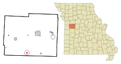 Location of Chilhowee, Missouri | |
| Coordinates: 38°35′20″N 93°51′16″W[1] | |
| Country | United States |
| State | Missouri |
| County | Johnson |
| Area | |
| • Total | 0.36 sq mi (0.93 km2) |
| • Land | 0.36 sq mi (0.93 km2) |
| • Water | 0.00 sq mi (0.00 km2) |
| Elevation | 922 ft (281 m) |
| Population (2020) | |
| • Total | 291 |
| • Density | 806.09/sq mi (311.64/km2) |
| Time zone | UTC-6 (Central (CST)) |
| • Summer (DST) | UTC-5 (CDT) |
| ZIP code | 64733 |
| Area code | 660 |
| FIPS code | 29-13654[3] |
| GNIS feature ID | 0729719[1] |
History
Chilhowee was originally called Simpson's Store, and under the latter name was founded in the mid-1850s, and named after James Simpson, a local merchant.[4] A post office called Chilhowee has been in operation since 1859.[5] The present name is of Native American origin.[6]
The Chilhowee Historic District was listed on the National Register of Historic Places in 1988.[7]
Geography
Chilhowee is located on Missouri Route 2 approximately two miles west of Post Oak and Missouri Route 13. Old Chilhowee is one mile north on Missouri Route F and Denton is four miles to the northwest on Route 2. The location is on the broad drainage divide between Post Oak Creek to the north and Big Creek tributaries to the south.[8]
According to the United States Census Bureau, the village has a total area of 0.38 square miles (0.98 km2), all land.[9]
Demographics
| Census | Pop. | Note | %± |
|---|---|---|---|
| 1870 | 185 | — | |
| 1880 | 86 | −53.5% | |
| 1910 | 425 | — | |
| 1920 | 469 | 10.4% | |
| 1930 | 414 | −11.7% | |
| 1940 | 415 | 0.2% | |
| 1950 | 335 | −19.3% | |
| 1960 | 339 | 1.2% | |
| 1970 | 297 | −12.4% | |
| 1980 | 349 | 17.5% | |
| 1990 | 335 | −4.0% | |
| 2000 | 329 | −1.8% | |
| 2010 | 325 | −1.2% | |
| 2020 | 291 | −10.5% | |
| U.S. Decennial Census[10] | |||
2010 census
As of the census[11] of 2010, there were 325 people, 129 households, and 85 families living in the village. The population density was 855.3 inhabitants per square mile (330.2/km2). There were 163 housing units at an average density of 428.9 per square mile (165.6/km2). The racial makeup of the village was 95.4% White, 0.9% Native American, and 3.7% from two or more races. Hispanic or Latino of any race were 1.2% of the population.
There were 129 households, of which 36.4% had children under the age of 18 living with them, 42.6% were married couples living together, 14.0% had a female householder with no husband present, 9.3% had a male householder with no wife present, and 34.1% were non-families. 28.7% of all households were made up of individuals, and 15.5% had someone living alone who was 65 years of age or older. The average household size was 2.52 and the average family size was 3.02.
The median age in the village was 35.1 years. 29.8% of residents were under the age of 18; 7.8% were between the ages of 18 and 24; 25.6% were from 25 to 44; 21.5% were from 45 to 64; and 15.4% were 65 years of age or older. The gender makeup of the village was 50.5% male and 49.5% female.
2000 census
As of the census[3] of 2000, there were 329 people, 142 households, and 78 families living in the village. The population density was 858.6 inhabitants per square mile (331.5/km2). There were 165 housing units at an average density of 430.6 per square mile (166.3/km2). The racial makeup of the village was 95.74% White, 0.61% African American, 0.30% Native American, and 3.34% from two or more races.
There were 142 households, out of which 28.9% had children under the age of 18 living with them, 46.5% were married couples living together, 7.0% had a female householder with no husband present, and 44.4% were non-families. 39.4% of all households were made up of individuals, and 23.2% had someone living alone who was 65 years of age or older. The average household size was 2.32 and the average family size was 3.20.
In the village the population was spread out, with 26.1% under the age of 18, 9.7% from 18 to 24, 29.2% from 25 to 44, 18.2% from 45 to 64, and 16.7% who were 65 years of age or older. The median age was 37 years. For every 100 females there were 98.2 males. For every 100 females age 18 and over, there were 99.2 males.
The median income for a household in the village was $29,688, and the median income for a family was $45,938. Males had a median income of $27,500 versus $20,625 for females. The per capita income for the village was $14,850. About 4.1% of families and 9.3% of the population were below the poverty line, including 11.7% of those under age 18 and 19.2% of those age 65 or over.
Points of interest
- Rock Island Spur Trailhead
Chilhowee Fair
The annual Chilhowee Fair is the main event that the city is most known for. The city fair takes place each year on labor day weekend usually beginning on Thursday evening and ending Saturday night. In 2007, Chilhowee celebrated their 60th annual fair. Fair events include arts and craft contests, vegetable and crop contests, parade, carnival, rodeo, concerts, and queen contests. The fair is highlighted by a street dance on Saturday night at the Chilhowee City Park often called the David Hill Special. It was announced that the 2018 fair would be the towns last.
Notable residents
- David Hill - Established business man and leader in community. In addition to many successful businesses in the town including the town bar and Rural Precision Motor (RPM), Hill also is president of the Chilhowee Fair Board.
- Eric Jackson - 1,000 point career scorer for the 2000 Chilhowee Indians High School basketball team, graduated from Chilhowee High School in 2000. Eric went on to play two seasons for the University of Missouri under Quin Snyder.
- Ronnie Greene - Lifelong Chilhowee resident best known for his homemade BBQ smoker and his ability to drink Old Taylor.
- Beth Weigand - Graduate of Chilhowee High School in 1999, went on to learn Spanish while in the peace corps and influence hundreds with her proven teaching style.
- Lee Pope - Chilhowee gentleman. Lee is best known for his warm handshake and friendly greeting, especially at the annual Chilhowee fair.
- Gordon Stegner - Leads the state in firm handshakes while maintaining eye contact, Stegner rivals Pope for the best handshake in town.
- Ms. Bonnie Tompkins - Once known as a "green thumb" while working as an aid at Chilhowee High School, Tompkins won over the town with her infectious smile and ability to hem any type of fabric.
- Dawn Martin - Long time bus driver for the Chilhowee school district. Made famous the phrase "Chilhowee bus 2 to base." Martin is also an avid bike rider and can be seen riding her bike around the countryside on many a nice day.
References
- U.S. Geological Survey Geographic Names Information System: Chilhowee, Missouri
- "ArcGIS REST Services Directory". United States Census Bureau. Retrieved August 28, 2022.
- "U.S. Census website". United States Census Bureau. Retrieved January 31, 2008.
- "Johnson County Place Names, 1928–1945 (archived)". The State Historical Society of Missouri. Archived from the original on June 24, 2016. Retrieved October 20, 2016.
{{cite web}}: CS1 maint: bot: original URL status unknown (link) - "Post Offices". Jim Forte Postal History. Archived from the original on May 25, 2015. Retrieved October 19, 2016.
- Bright, William (2004). Native American Placenames of the United States. University of Oklahoma Press. p. 100. ISBN 978-0-8061-3598-4.
- "National Register Information System". National Register of Historic Places. National Park Service. July 9, 2010.
- Missouri Atlas & Gazetteer, DeLorme, First Edition 1998, p.35, ISBN 0899332242
- "US Gazetteer files 2010". United States Census Bureau. Archived from the original on January 25, 2012. Retrieved July 8, 2012.
- "Census of Population and Housing". Census.gov. Retrieved June 4, 2015.
- "U.S. Census website". United States Census Bureau. Retrieved July 8, 2012.
External links
- City of Chilhowee
- Chilhowee R-IV Schools
- Historic maps of Chilhowee in the Sanborn Maps of Missouri Collection at the University of Missouri
Municipalities and communities of Johnson County, Missouri, United States | ||
|---|---|---|
| Cities |  Map of Missouri highlighting Johnson County | |
| Townships | ||
| CDPs | ||
| Unincorporated communities | ||
| Footnotes | ‡This populated place also has portions in an adjacent county or counties | |