Chotýšany
Chotýšany is a municipality and village in Benešov District in the Central Bohemian Region of the Czech Republic. It has about 700 inhabitants.
Chotýšany | |
|---|---|
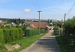 View from the south | |
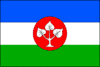 Flag | |
 Chotýšany Location in the Czech Republic | |
| Coordinates: 49°44′39″N 14°48′53″E | |
| Country | |
| Region | Central Bohemian |
| District | Benešov |
| First mentioned | 1250 |
| Area | |
| • Total | 13.97 km2 (5.39 sq mi) |
| Elevation | 450 m (1,480 ft) |
| Population (2023-01-01)[1] | |
| • Total | 650 |
| • Density | 47/km2 (120/sq mi) |
| Time zone | UTC+1 (CET) |
| • Summer (DST) | UTC+2 (CEST) |
| Postal codes | 257 01, 257 28 |
| Website | www |
Administrative parts
Villages of Křemení, Městečko and Pařezí are administrative parts of Chotýšany.
Geography
Chotýšany is located about 16 kilometres (10 mi) east of Benešov and 43 km (27 mi) southeast of Prague. It lies in the Benešov Uplands. The highest point is the hill Vápenný vrch at 497 m (1,631 ft) above sea level. The municipal territory is rich in minor brooks and ponds. The Chotýšanka River flows through the municipality.
History
The first written mention of Chotýšany is from 1250.[2]
Sights
The most important monument is the Church of Saint Gall. It was first documented in 1357. Originally a Romanesque building, it was rebuilt into its present Gothic form. The façade is the result of neo-Gothic modifications.[2][3]
The Chotýšany Castle was built in the first half of the 18th century next to remains of a medieval fortress. The southern wing is baroque; the northwern neo-Gothic wing was added in the mid-19th century. Today the buildings of the castle are dilapidated and unused.[2][4]
Gallery
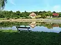 Common pond
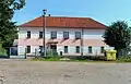 Primary school
References
- "Population of Municipalities – 1 January 2023". Czech Statistical Office. 2023-05-23.
- "Informace o obci" (in Czech). Obec Chotýšany. Retrieved 2023-04-14.
- "Kostel sv. Havla" (in Czech). National Heritage Institute. Retrieved 2023-04-14.
- "Zámek" (in Czech). National Heritage Institute. Retrieved 2023-04-14.