Clarence, Louisiana
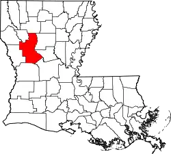
Clarence is a village in Natchitoches Parish, Louisiana, United States. The population was 499 at the 2010 census. It is located some seven miles east of the parish seat of Natchitoches and is part of the Natchitoches Micropolitan Statistical Area.
Clarence, Louisiana | |
|---|---|
| Village of Clarence | |
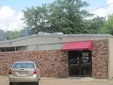
 Grayson Barbeque in Clarence, with a smokehouse, draws clientele from beyond the village because of its regional reputation and location on U.S. Highway 71 near the intersection with U.S. Highway 84. | |
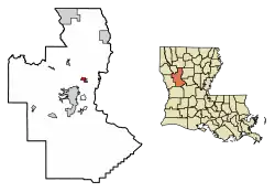
 Location of Clarence in Natchitoches Parish, Louisiana. | |
 Clarence, Louisiana  Clarence, Louisiana | |
| Coordinates: 31°49′13″N 93°01′44″W | |
| Country | United States |
| States | Louisiana |
| Parish | Natchitoches |
| Area | |
| • Total | 1.58 sq mi (4.08 km2) |
| • Land | 1.57 sq mi (4.07 km2) |
| • Water | 0.00 sq mi (0.01 km2) |
| Population (2020) | |
| • Total | 326 |
| • Rank | NC: 5th |
| • Density | 207.38/sq mi (80.09/km2) |
| Time zone | UTC-6 (CST) |
| • Summer (DST) | UTC-5 (CDT) |
| ZIP code | 71414 |
| Area code | 318 |
Still owned by descendants of its founders, Grayson Barbeque, with a smokehouse, is the best known business in Clarence. It is located on U.S. Highway 71 near the intersection with U.S. Highway 84, which leads to Winnfield.[2]
History

The Harrisonburg Road or the Natchez Trace ran through the area as it crossed Louisiana into Texas to connect with the El Camino Real.
Demographics
| Census | Pop. | Note | %± |
|---|---|---|---|
| 1960 | 286 | — | |
| 1970 | 448 | 56.6% | |
| 1980 | 612 | 36.6% | |
| 1990 | 577 | −5.7% | |
| 2000 | 516 | −10.6% | |
| 2010 | 499 | −3.3% | |
| 2020 | 326 | −34.7% | |
| U.S. Decennial Census[3] | |||
2020 census
| Race | Number | Percentage |
|---|---|---|
| White (non-Hispanic) | 69 | 21.17% |
| Black or African American (non-Hispanic) | 239 | 73.31% |
| Native American | 3 | 0.92% |
| Other/Mixed | 13 | 3.99% |
| Hispanic or Latino | 2 | 0.61% |
As of the 2020 United States census, there were 326 people, 131 households, and 58 families residing in the village.
2010 census
At the 2010 census[5] , there were 499 people, 186 households and 136 families residing in the village. The population density was 311.9 inhabitants per square mile (120.4/km2). There were 204 housing units at an average density of 127.5 per square mile (49.2/km2). The racial makeup of the village was 23.2% White, 75.2% African American, and 1.2% from two or more races. Hispanic or Latino of any race were 2.2% of the population.
There were 186 households, of which 36% had children under the age of 18 living with them, 37.1% were married couples living together, 30.6% had a female householder with no husband present, and 26.9% were non-families. 22% of all households were made up of individuals, and 9.1% had someone living alone who was 65 years of age or older. The average household size was 2.68 and the average family size was 3.13.
Age distribution was 29.1% under the age of 18, 9.3% from 18 to 24, 21.6% from 25 to 44, 28% from 45 to 64, and 12.0% who were 65 years of age or older. The median age was 36.5 years. For every 100 females, there were 87.6 males. For every 100 females age 18 and over, there were 78.5 males.
At the 2000 census[6] The median household income was $25,278, and the median family income was $25,694. Males had a median income of $24,375 versus $17,841 for females. The per capita income for the village was $13,360. About 27.9% of families and 28.3% of the population were below the poverty line, including 36.9% of those under age 18 and 40.0% of those age 65 or over.
Geography
Clarence is located at 31°49′13″N 93°1′44″W (31.820143, −93.028773).[7]
According to the United States Census Bureau, the village has a total area of 1.6 square miles (4.1 km2), all land.
Climate
Climate is characterized by relatively high temperatures and evenly distributed precipitation throughout the year. The Köppen Climate Classification subtype for this climate is "Cfa". (Humid Subtropical Climate).[8]
| Climate data for Clarence, Louisiana | |||||||||||||
|---|---|---|---|---|---|---|---|---|---|---|---|---|---|
| Month | Jan | Feb | Mar | Apr | May | Jun | Jul | Aug | Sep | Oct | Nov | Dec | Year |
| Average high °C (°F) | 15 (59) |
17 (63) |
22 (71) |
26 (79) |
29 (85) |
33 (91) |
34 (94) |
34 (94) |
32 (89) |
27 (80) |
21 (69) |
17 (62) |
26 (78) |
| Average low °C (°F) | 3 (38) |
4 (40) |
8 (46) |
12 (54) |
17 (62) |
21 (69) |
22 (72) |
22 (71) |
18 (65) |
12 (54) |
7 (45) |
4 (39) |
13 (55) |
| Average precipitation mm (inches) | 130 (5.1) |
120 (4.7) |
120 (4.9) |
120 (4.6) |
130 (5.2) |
110 (4.2) |
89 (3.5) |
76 (3.0) |
84 (3.3) |
97 (3.8) |
110 (4.5) |
130 (5.3) |
1,316 (52.1) |
| Source: Weatherbase [9] | |||||||||||||
References
- "2020 U.S. Gazetteer Files". United States Census Bureau. Retrieved March 20, 2022.
- "Grayson Barbeque in Clarence". yelp.com. Retrieved August 17, 2009.
- "Census of Population and Housing". Census.gov. Retrieved June 4, 2015.
- "Explore Census Data". data.census.gov. Retrieved December 29, 2021.
- "U.S. Census website". United States Census Bureau. Retrieved July 15, 2011.
- "U.S. Census website". United States Census Bureau. Retrieved January 31, 2008.
- "US Gazetteer files: 2010, 2000, and 1990". United States Census Bureau. February 12, 2011. Retrieved April 23, 2011.
- Climate Summary for closest city on record
- "Weatherbase.com". Weatherbase. 2013. Retrieved on May 8, 2013.
