Herøy, Møre og Romsdal
Herøy is a municipality in Møre og Romsdal county, Norway. It is part of the Sunnmøre region. The administrative centre is the town of Fosnavåg on the island of Bergsøya. The industrial area of Eggesbønes is located south of Fosnavåg on the same island. The Runde Environmental Centre is located in the northern part of the municipality on Runde island. Other population centres in Herøy include the villages of Leikong, Kvalsund, or Moltustranda.
Herøy kommune
Herø herred (historic) | |
|---|---|
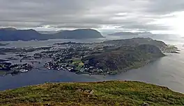
 View of Fosnavåg | |
.gif) Flag  Møre og Romsdal within Norway | |
 Herøy within Møre og Romsdal | |
| Coordinates: 62°21′20″N 05°32′40″E | |
| Country | Norway |
| County | Møre og Romsdal |
| District | Sunnmøre |
| Established | 1 Jan 1838 |
| • Created as | Formannskapsdistrikt |
| Administrative centre | Fosnavåg |
| Government | |
| • Mayor (2019) | Bjørn-Halvor Prytz (Ap) |
| Area | |
| • Total | 119.52 km2 (46.15 sq mi) |
| • Land | 118.01 km2 (45.56 sq mi) |
| • Water | 1.51 km2 (0.58 sq mi) 1.3% |
| • Rank | #320 in Norway |
| Population (2022) | |
| • Total | 8,765 |
| • Rank | #123 in Norway |
| • Density | 74.3/km2 (192/sq mi) |
| • Change (10 years) | |
| Demonym | Herøyværing[1] |
| Official language | |
| • Norwegian form | Nynorsk |
| Time zone | UTC+01:00 (CET) |
| • Summer (DST) | UTC+02:00 (CEST) |
| ISO 3166 code | NO-1515 |
| Website | Official website |

The 120-square-kilometre (46 sq mi) municipality is the 320th largest by area out of the 356 municipalities in Norway. Herøy is the 123rd most populous municipality in Norway with a population of 8,765. The municipality's population density is 74.3 inhabitants per square kilometre (192/sq mi) and its population has increased by 0.4% over the previous 10-year period.[3][4]
General information
The prestegjeld (parish) of Herøy was established as a municipality on 1 January 1838 (see formannskapsdistrikt law). On 1 January 1867, the western district of Herøy was separated to become the new Sande Municipality. This left Herøy municipality with 1,999 residents. On 1 January 1873, an area of Sande (population: 362) was transferred back to Herøy. On 1 January 1889, the Eiksund area and Ekø island (population: 119) were transferred from Sande to Herøy.[5]
During the 1960s, there were many municipal mergers across Norway due to the work of the Schei Committee. On 1 January 1964, three farms in the Gurskedalen valley (population: 25) were transferred from Herøy to Sande. Also on that date, the Eiksund area and the Eika island (population: 222) were transferred from Herøy to neighboring Ulstein Municipality.[5]
Name
The municipality (originally the parish) is named after an archipelago of small islands (Old Norse: Herøyjar). The first element is herr which means "army". The word here is referring to the idea of skipaherr which means "military fleet", referring to the many islands grouped together. The last element is øy which means "island". Prior to 1918, the name was written Herø.[6]
Coat of arms
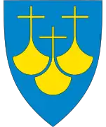
The coat of arms was granted on 27 March 1987. The official blazon is "Azure, two ship bows argent issuant from the flanks" (Norwegian: På blå grunn to motstilte sølv skipsstamnar). This means the arms have a blue field (background) and the charge is two stems of a ship. The charge has a tincture of argent which means it is commonly colored white, but if it is made out of metal, then silver is used. This design was chosen to represent the 7th century Kvalsund boats found in the municipality. The arms were designed by Even Jarl Skoglund. The municipal flag has the same design as the coat of arms.[7][8][9]
Churches
The Church of Norway has three parishes (sokn) within the municipality of Herøy. It is part of the Søre Sunnmøre prosti (deanery) in the Diocese of Møre.
| Parish (sokn) | Church name | Location of the church | Year built |
|---|---|---|---|
| Herøy | Herøy Church | Fosnavåg | 2003 |
| Indre Herøy | Indre Herøy Church | Stokksund on Gurskøya | 1916 |
| Leikanger | Leikanger Church | Leikong | 1807 |
Government
All municipalities in Norway are responsible for primary education (through 10th grade), outpatient health services, senior citizen services, welfare and other social services, zoning, economic development, and municipal roads and utilities. The municipality is governed by a municipal council of directly elected representatives. The mayor is indirectly elected by a vote of the municipal council.[10] The municipality falls under the Møre og Romsdal District Court and the Frostating Court of Appeal.
Municipal council
The municipal council (Kommunestyre) of Herøy is made up of 33 representatives that are elected to four year terms. The party breakdown of the council is as follows:
| Party Name (in Nynorsk) | Number of representatives | |
|---|---|---|
| Labour Party (Arbeidarpartiet) | 7 | |
| Progress Party (Framstegspartiet) | 3 | |
| Conservative Party (Høgre) | 10 | |
| Christian Democratic Party (Kristeleg Folkeparti) | 6 | |
| Centre Party (Senterpartiet) | 3 | |
| People's list (Folkelista) | 4 | |
| Total number of members: | 33 | |
| Party Name (in Nynorsk) | Number of representatives | |
|---|---|---|
| Labour Party (Arbeidarpartiet) | 10 | |
| Progress Party (Framstegspartiet) | 3 | |
| Conservative Party (Høgre) | 11 | |
| Christian Democratic Party (Kristeleg Folkeparti) | 4 | |
| Liberal Party (Venstre) | 1 | |
| Local List(s) (Lokale lister) | 4 | |
| Total number of members: | 33 | |
| Party Name (in Nynorsk) | Number of representatives | |
|---|---|---|
| Labour Party (Arbeidarpartiet) | 6 | |
| Progress Party (Framstegspartiet) | 3 | |
| Conservative Party (Høgre) | 15 | |
| Christian Democratic Party (Kristeleg Folkeparti) | 5 | |
| Liberal Party (Venstre) | 1 | |
| Local List(s) (Lokale lister) | 3 | |
| Total number of members: | 33 | |
| Party Name (in Nynorsk) | Number of representatives | |
|---|---|---|
| Labour Party (Arbeidarpartiet) | 5 | |
| Progress Party (Framstegspartiet) | 4 | |
| Conservative Party (Høgre) | 14 | |
| Christian Democratic Party (Kristeleg Folkeparti) | 5 | |
| Liberal Party (Venstre) | 1 | |
| People's list - cross-party list for village and town (Folkelista – tverrpolitisk liste for bygd og by) | 4 | |
| Total number of members: | 33 | |
| Party Name (in Nynorsk) | Number of representatives | |
|---|---|---|
| Labour Party (Arbeidarpartiet) | 7 | |
| Progress Party (Framstegspartiet) | 3 | |
| Conservative Party (Høgre) | 4 | |
| Christian Democratic Party (Kristeleg Folkeparti) | 3 | |
| Socialist Left Party (Sosialistisk Venstreparti) | 1 | |
| Liberal Party (Venstre) | 1 | |
| People's list - cross-party list (Folkelista - Tverrpolitisk liste) | 6 | |
| Total number of members: | 25 | |
| Party Name (in Nynorsk) | Number of representatives | |
|---|---|---|
| Labour Party (Arbeidarpartiet) | 11 | |
| Progress Party (Framstegspartiet) | 3 | |
| Conservative Party (Høgre) | 5 | |
| Christian Democratic Party (Kristeleg Folkeparti) | 8 | |
| Centre Party (Senterpartiet) | 1 | |
| Socialist Left Party (Sosialistisk Venstreparti) | 1 | |
| Liberal Party (Venstre) | 4 | |
| Total number of members: | 33 | |
| Party Name (in Nynorsk) | Number of representatives | |
|---|---|---|
| Labour Party (Arbeidarpartiet) | 8 | |
| Progress Party (Framstegspartiet) | 2 | |
| Conservative Party (Høgre) | 5 | |
| Christian Democratic Party (Kristeleg Folkeparti) | 6 | |
| Centre Party (Senterpartiet) | 3 | |
| Socialist Left Party (Sosialistisk Venstreparti) | 1 | |
| Liberal Party (Venstre) | 5 | |
| Herøy List (Herøylista) | 3 | |
| Total number of members: | 33 | |
| Party Name (in Nynorsk) | Number of representatives | |
|---|---|---|
| Labour Party (Arbeidarpartiet) | 9 | |
| Progress Party (Framstegspartiet) | 2 | |
| Conservative Party (Høgre) | 5 | |
| Christian Democratic Party (Kristeleg Folkeparti) | 7 | |
| Centre Party (Senterpartiet) | 3 | |
| Socialist Left Party (Sosialistisk Venstreparti) | 2 | |
| Liberal Party (Venstre) | 2 | |
| Herøy List (Herøylista) | 3 | |
| Total number of members: | 33 | |
| Party Name (in Nynorsk) | Number of representatives | |
|---|---|---|
| Labour Party (Arbeidarpartiet) | 8 | |
| Conservative Party (Høgre) | 7 | |
| Christian Democratic Party (Kristeleg Folkeparti) | 8 | |
| Centre Party (Senterpartiet) | 2 | |
| Liberal Party (Venstre) | 3 | |
| Herøy List cross-party election list (Herøylista Tverrpolitiske valliste) | 5 | |
| Total number of members: | 33 | |
| Party Name (in Nynorsk) | Number of representatives | |
|---|---|---|
| Labour Party (Arbeidarpartiet) | 8 | |
| Conservative Party (Høgre) | 8 | |
| Christian Democratic Party (Kristeleg Folkeparti) | 10 | |
| Centre Party (Senterpartiet) | 3 | |
| Liberal Party (Venstre) | 4 | |
| Total number of members: | 33 | |
| Party Name (in Nynorsk) | Number of representatives | |
|---|---|---|
| Labour Party (Arbeidarpartiet) | 6 | |
| Conservative Party (Høgre) | 10 | |
| Christian Democratic Party (Kristeleg Folkeparti) | 9 | |
| Centre Party (Senterpartiet) | 3 | |
| Liberal Party (Venstre) | 5 | |
| Total number of members: | 33 | |
| Party Name (in Nynorsk) | Number of representatives | |
|---|---|---|
| Labour Party (Arbeidarpartiet) | 8 | |
| Conservative Party (Høgre) | 3 | |
| Christian Democratic Party (Kristeleg Folkeparti) | 10 | |
| Centre Party (Senterpartiet) | 4 | |
| Liberal Party (Venstre) | 5 | |
| Liberal People's Party and Independents (Det Nye Folkepartiet og Upolitiske) |
1 | |
| Non-party list for Moltustranda, Sandvik, Notøy, and Flåvær (Upolitisk liste for Moltustranda, Sandvik, Notøy og Flåvær) | 2 | |
| Total number of members: | 33 | |
| Party Name (in Nynorsk) | Number of representatives | |
|---|---|---|
| Labour Party (Arbeidarpartiet) | 8 | |
| Conservative Party (Høgre) | 2 | |
| Christian Democratic Party (Kristeleg Folkeparti) | 9 | |
| Centre Party (Senterpartiet) | 5 | |
| Liberal Party (Venstre) | 7 | |
| Local List(s) (Lokale lister) | 2 | |
| Total number of members: | 33 | |
| Party Name (in Nynorsk) | Number of representatives | |
|---|---|---|
| Labour Party (Arbeidarpartiet) | 8 | |
| Conservative Party (Høgre) | 3 | |
| Christian Democratic Party (Kristeleg Folkeparti) | 11 | |
| Centre Party (Senterpartiet) | 4 | |
| Liberal Party (Venstre) | 7 | |
| Total number of members: | 33 | |
| Party Name (in Nynorsk) | Number of representatives | |
|---|---|---|
| Labour Party (Arbeidarpartiet) | 4 | |
| Local List(s) (Lokale lister) | 29 | |
| Total number of members: | 33 | |
| Party Name (in Nynorsk) | Number of representatives | |
|---|---|---|
| Labour Party (Arbeidarpartiet) | 1 | |
| Local List(s) (Lokale lister) | 32 | |
| Total number of members: | 33 | |
| Party Name (in Nynorsk) | Number of representatives | |
|---|---|---|
| Labour Party (Arbeidarpartiet) | 5 | |
| Local List(s) (Lokale lister) | 28 | |
| Total number of members: | 33 | |
| Party Name (in Nynorsk) | Number of representatives | |
|---|---|---|
| Labour Party (Arbeidarpartiet) | 1 | |
| Local List(s) (Lokale lister) | 31 | |
| Total number of members: | 32 | |
| Party Name (in Nynorsk) | Number of representatives | |
|---|---|---|
| Local List(s) (Lokale lister) | 32 | |
| Total number of members: | 32 | |
| Party Name (in Nynorsk) | Number of representatives | |
|---|---|---|
| Labour Party (Arbeidarpartiet) | 1 | |
| List of workers, fishermen, and small farmholders (Arbeidarar, fiskarar, småbrukarar liste) | 2 | |
| Local List(s) (Lokale lister) | 29 | |
| Total number of members: | 32 | |
| Party Name (in Nynorsk) | Number of representatives | |
|---|---|---|
| Labour Party (Arbeidarpartiet) | 5 | |
| Joint List(s) of Non-Socialist Parties (Borgarlege Felleslister) | 3 | |
| Local List(s) (Lokale lister) | 24 | |
| Total number of members: | 32 | |
| Note: Due to the German occupation of Norway during World War II, no elections were held for new municipal councils until after the war ended in 1945. | ||
Mayors
- 1837–1843: Christoffer Mathias Rønneberg
- 1844–1845: Peter Wilhelm L'orange
- 1846–1849: Aage Schavland
- 1850–1851: Knut A. Brekke
- 1852–1853: Knut R. Bjørlykke
- 1854–1857: Aage Schavland
- 1858–1872: Ole Thorseth
- 1873–1876: Peter M. Jacobsen
- 1877–1886: Ole Thorseth (H)
- 1887–1888: Peter M. Jacobsen
- 1889–1892: Annanias Stavøstrand (MV)
- 1893–1894: Gustav Wiig (H)
- 1895–1907: Severin Sundnes (H)
- 1908–1917: Rasmus Moltu (V)
- 1918–1919: Paul Moltu (V)
- 1920–1922: Lars Havåg (V)
- 1923–1931: Abel Berge (V)
- 1932–1934: Hans P.J. Runde
- 1935–1941: Ole Garvik (V)
- 1942–1945: Hjalmar Jacobsen (NS)
- 1945–1947: Ole Garvik (V)
- 1948–1955: Ivar Nærø
- 1956–1958: Bjarne Rekdal (Ap)
- 1958–1959: Olav Thorseth
- 1960–1961: Magnus Berge
- 1962–1971: Rolf Ervik
- 1972–1975: Knut Nærø
- 1976–1979: Einar Leinebø
- 1980–1987: Charles Remø (H)
- 1988–1989: Per Rolf Sævik (KrF)
- 1990–1995: Svein Gjelseth (Ap)
- 1995–1999: Leif G. Igesund (KrF)
- 1999–2003: Svein Gjelseth (Ap)
- 2003–2019: Arnulf Goksøyr (H)
- 2019-present: Bjørn-Halvor Prytz (Ap)
Geography
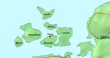
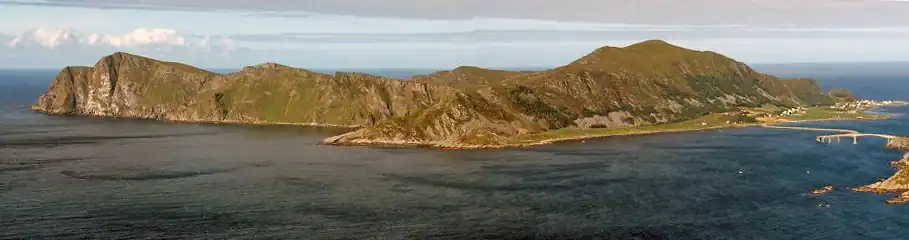
The main population and administrative centre of the municipality is the town of Fosnavåg, located on the island of Bergsøya. The municipality is entirely composed of islands located north of the Rovdefjorden. It includes the main islands of Bergsøya, Leinøya, Nerlandsøya, Remøya, Runde, Skorpa, Flåvær, and the eastern part of Gurskøya, plus many smaller islands. The island of Runde is especially notable for its large seabird colonies (and Runde Lighthouse), while Skorpa is famous for its role as a station for the Shetland bus. The islands are connected together via a series of bridges including the Runde Bridge, Remøy Bridge, Herøy Bridge, and Nerlandsøy Bridge.
The Herøyfjorden bisects Herøy municipality. The half located south of the fjord is referred to as Inner Herøy, while the half located north of the fjord is referred to as Outer Herøy. Inner and Outer Herøy are tied together by the Herøy Bridge which connects the islands of Gurskøy and Leinøya. Along this main route of traffic is the islet Notøy and the even smaller Herøya islet, an old trading station (now museum) and the original location of the original Herøy Church.
The fishing station Flåvær is located on a group of islets and skerries in the Herøyfjord, It includes the islets Flåvær, Husholmen, Torvholmen and Varholmen. The Flåvær Lighthouse is located on Varholmen.
The Svinøy Lighthouse is located on the very small island of Svinøy, about 12 kilometres (7.5 mi) west of the island of Skorpa.
Notable people
- Hans Peter L'orange (1835 in Herøy – 1907) military officer, the Commanding General in Norway, 1897 to 1903
- Suzannah Ibsen (1836 in Herøy – 1914) the wife of playwright and poet Henrik Ibsen
- Aage Skavlan (1847 in Herøy – 1920) a Norwegian historian and academic
- Harald Skavlan (1854 in Herøy – 1908) a Norwegian railroad engineer
- Johannes A. Bøe (1882 at Bøe in Herøy – 1970) a Norwegian politician; Mayor of Jevnaker, 1922 to 1925
- Per Rolf Sævik (born 1940 in Herøy) a fisherman, ship-owner and politician; Mayor of Herøy, 1987 to 1989
- Synnøve Eriksen (born 1963 in Herøy) a Norwegian novelist
References
- "Navn på steder og personer: Innbyggjarnamn" (in Norwegian). Språkrådet.
- "Forskrift om målvedtak i kommunar og fylkeskommunar" (in Norwegian). Lovdata.no.
- Statistisk sentralbyrå. "Table: 06913: Population 1 January and population changes during the calendar year (M)" (in Norwegian).
- Statistisk sentralbyrå. "09280: Area of land and fresh water (km²) (M)" (in Norwegian).
- Jukvam, Dag (1999). Historisk oversikt over endringer i kommune- og fylkesinndelingen (PDF) (in Norwegian). Statistisk sentralbyrå. ISBN 9788253746845.
- Rygh, Oluf (1908). Norske gaardnavne: Romsdals amt (in Norwegian) (13 ed.). Kristiania, Norge: W. C. Fabritius & sønners bogtrikkeri. p. 36.
- "Civic heraldry of Norway - Norske Kommunevåpen". Heraldry of the World. Retrieved 15 April 2023.
- "Herøy, Møre og Romsdal (Norway)". Flags of the World. Retrieved 15 April 2023.
- "Godkjenning av våpen og flagg". Lovdata.no (in Norwegian). Norges kommunal- og arbeidsdepartementet. 27 March 1987. Retrieved 15 April 2023.
- Hansen, Tore; Vabo, Signy Irene, eds. (20 September 2022). "kommunestyre". Store norske leksikon (in Norwegian). Kunnskapsforlaget. Retrieved 14 October 2022.
- "Tall for Norge: Kommunestyrevalg 2019 - Møre og Romsdal" (in Norwegian). Statistics Norway. Retrieved 19 October 2019.
- "Table: 04813: Members of the local councils, by party/electoral list at the Municipal Council election (M)" (in Norwegian). Statistics Norway.
- "Tall for Norge: Kommunestyrevalg 2011 - Møre og Romsdal" (in Norwegian). Statistics Norway. Retrieved 19 October 2019.
- "Kommunestyrevalget 1995" (PDF) (in Norwegian). Oslo-Kongsvinger: Statistisk sentralbyrå. 1996. Retrieved 1 May 2020.
- "Kommunestyrevalget 1991" (PDF) (in Norwegian). Oslo-Kongsvinger: Statistisk sentralbyrå. 1993. Retrieved 1 May 2020.
- "Kommunestyrevalget 1987" (PDF) (in Norwegian). Oslo-Kongsvinger: Statistisk sentralbyrå. 1988. Retrieved 1 May 2020.
- "Kommunestyrevalget 1983" (PDF) (in Norwegian). Oslo-Kongsvinger: Statistisk sentralbyrå. 1984. Retrieved 1 May 2020.
- "Kommunestyrevalget 1979" (PDF) (in Norwegian). Oslo: Statistisk sentralbyrå. 1979. Retrieved 1 May 2020.
- "Kommunevalgene 1975" (PDF) (in Norwegian). Oslo: Statistisk sentralbyrå. 1977. Retrieved 1 May 2020.
- "Kommunevalgene 1972" (PDF) (in Norwegian). Oslo: Statistisk sentralbyrå. 1973. Retrieved 1 May 2020.
- "Kommunevalgene 1967" (PDF) (in Norwegian). Oslo: Statistisk sentralbyrå. 1967. Retrieved 1 May 2020.
- "Kommunevalgene 1963" (PDF) (in Norwegian). Oslo: Statistisk sentralbyrå. 1964. Retrieved 1 May 2020.
- "Kommunevalgene og Ordførervalgene 1959" (PDF) (in Norwegian). Oslo: Statistisk sentralbyrå. 1960. Retrieved 1 May 2020.
- "Kommunevalgene og Ordførervalgene 1955" (PDF) (in Norwegian). Oslo: Statistisk sentralbyrå. 1957. Retrieved 1 May 2020.
- "Kommunevalgene og Ordførervalgene 1951" (PDF) (in Norwegian). Oslo: Statistisk sentralbyrå. 1952. Retrieved 1 May 2020.
- "Kommunevalgene og Ordførervalgene 1947" (PDF) (in Norwegian). Oslo: Statistisk sentralbyrå. 1948. Retrieved 1 May 2020.
- "Kommunevalgene og Ordførervalgene 1945" (PDF) (in Norwegian). Oslo: Statistisk sentralbyrå. 1947. Retrieved 1 May 2020.
- "Kommunevalgene og Ordførervalgene 1937" (PDF) (in Norwegian). Oslo: Statistisk sentralbyrå. 1938. Retrieved 1 May 2020.
- Rabben, Bjarne (1973). "Ordførarar". Herøyboka. Bygdesoga (in Norwegian). Vol. II. Herøy sogelag. pp. 75–77.
External links
- Municipal fact sheet from Statistics Norway (in Norwegian)
- The Bird Island of Runde (in German)
- Herøy Kommune (in Norwegian)
Møre og Romsdal county, Norway | |||
|---|---|---|---|
| |||
 | Towns and cities |
|  |
| Municipalities | |||