Samnanger
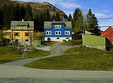
Samnanger (Urban East Norwegian: [ˈsɑ̂mnɑŋər]) is a municipality in the Midhordland region of Vestland county, Norway. The administrative centre of the municipality is the village of Tysse. Other main villages in the municipality include Haga and Bjørkheim in Nordbygda. The municipality is located about 20 kilometres (12 mi) east of the city of Bergen, Norway's second largest city. It surrounds the inner part of the Samnangerfjorden and the surrounding valleys. There are mountains that surround the municipality. The development of hydroelectric power plants started here in 1909.
Samnanger kommune | |
|---|---|
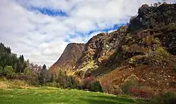 View of Kvittingen valley area | |
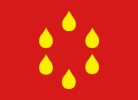 Flag  Vestland within Norway | |
 Samnanger within Vestland | |
| Coordinates: 60°24′10″N 05°48′20″E | |
| Country | Norway |
| County | Vestland |
| District | Midhordland |
| Established | 1 Jan 1907 |
| • Preceded by | Os Municipality |
| Administrative centre | Tysse |
| Government | |
| • Mayor (2015) | Knut Harald Frøland (Local list) |
| Area | |
| • Total | 269.07 km2 (103.89 sq mi) |
| • Land | 257.41 km2 (99.39 sq mi) |
| • Water | 11.66 km2 (4.50 sq mi) 4.3% |
| • Rank | #274 in Norway |
| Population (2022) | |
| • Total | 2,501 |
| • Rank | #251 in Norway |
| • Density | 9.7/km2 (25/sq mi) |
| • Change (10 years) | |
| Demonym | Samning[1] |
| Official language | |
| • Norwegian form | Nynorsk |
| Time zone | UTC+01:00 (CET) |
| • Summer (DST) | UTC+02:00 (CEST) |
| ISO 3166 code | NO-4623 |
| Website | Official website |
The 269-square-kilometre (104 sq mi) municipality is the 274th largest by area out of the 356 municipalities in Norway. Samnanger is the 251st most populous municipality in Norway with a population of 2,501. The municipality's population density is 9.7 inhabitants per square kilometre (25/sq mi) and its population has increased by 3.5% over the previous 10-year period.[3][4]
In 2016, the chief of police for Vestlandet formally suggested a reconfiguration of police districts and stations. He proposed that the police station in Samnanger be closed.[5]
General information

The municipality of Samnanger was established on 1 January 1907 when it was separated from the municipality of Os. Initially, Samnanger had 3,025 residents. The borders of the municipality have not changed since that time.[6]
Name
The municipality (originally the parish) is named after the Samnangerfjorden (Old Norse: Samnangr) since it is a central geographic feature in the area. The first element is likely the old name for a local river, possibly derived from the word sǫmn which has an unknown meaning. The last element is angr which means "bay" or "inlet".[7][8]
Coat of arms
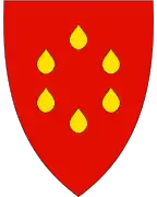
The coat of arms was granted on 27 April 1990. The official blazon is "Gules, six gouttes Or in annulo" (Norwegian: På raud grunn seks gule dråpar som lagar ein sirkel). This means the arms have a red field (background) and the charge is a set of six gouttes (drops of water) arranged in a circle. The charge has a tincture of Or which means it is commonly colored yellow, but if it is made out of metal, then gold is used. Water was chosen as a symbol on the arms because of the wet climate and the source of hydroelectricity that is prevalent in the area. The arms were designed by Even Jarl Skoglund. The municipal flag has the same design as the coat of arms.[9][10][11]
Churches
The Church of Norway has one parish (sokn) within the municipality of Samnanger. It is part of the Hardanger og Voss prosti (deanery) in the Diocese of Bjørgvin.
| Parish (sokn) | Church name | Location of the church | Year built |
|---|---|---|---|
| Samnanger | Haga Church | Haga | 1995 |
| Samnanger Church | Ådland | 1851 |
Government
All municipalities in Norway are responsible for primary education (through 10th grade), outpatient health services, senior citizen services, welfare and other social services, zoning, economic development, and municipal roads and utilities. The municipality is governed by a municipal council of directly elected representatives. The mayor is indirectly elected by a vote of the municipal council.[12] The municipality falls under the Hordaland District Court and the Gulating Court of Appeal.
Municipal council
The municipal council (Kommunestyre) of Samnanger is made up of 21 representatives that are elected to four year terms. The party breakdown of the council is as follows:
| Party Name (in Nynorsk) | Number of representatives | |
|---|---|---|
| Labour Party (Arbeidarpartiet) | 4 | |
| Progress Party (Framstegspartiet) | 3 | |
| Green Party (Miljøpartiet Dei Grøne) | 2 | |
| Conservative Party (Høgre) | 1 | |
| Christian Democratic Party (Kristeleg Folkeparti) | 1 | |
| Centre Party (Senterpartiet) | 2 | |
| Local List (Bygdalista) | 8 | |
| Total number of members: | 21 | |
| Party Name (in Nynorsk) | Number of representatives | |
|---|---|---|
| Labour Party (Arbeidarpartiet) | 5 | |
| Progress Party (Framstegspartiet) | 4 | |
| Green Party (Miljøpartiet Dei Grøne) | 1 | |
| Conservative Party (Høgre) | 2 | |
| Christian Democratic Party (Kristeleg Folkeparti) | 2 | |
| Centre Party (Senterpartiet) | 2 | |
| Local List (Bygdalista) | 5 | |
| Total number of members: | 21 | |
| Party Name (in Nynorsk) | Number of representatives | |
|---|---|---|
| Labour Party (Arbeidarpartiet) | 6 | |
| Progress Party (Framstegspartiet) | 4 | |
| Conservative Party (Høgre) | 2 | |
| Christian Democratic Party (Kristeleg Folkeparti) | 4 | |
| Centre Party (Senterpartiet) | 2 | |
| Local List (Bygdalista) | 3 | |
| Total number of members: | 21 | |
| Party Name (in Nynorsk) | Number of representatives | |
|---|---|---|
| Labour Party (Arbeidarpartiet) | 6 | |
| Progress Party (Framstegspartiet) | 3 | |
| Conservative Party (Høgre) | 2 | |
| Christian Democratic Party (Kristeleg Folkeparti) | 5 | |
| Centre Party (Senterpartiet) | 2 | |
| Local List (Bygdalista) | 3 | |
| Total number of members: | 21 | |
| Party Name (in Nynorsk) | Number of representatives | |
|---|---|---|
| Labour Party (Arbeidarpartiet) | 7 | |
| Progress Party (Framstegspartiet) | 2 | |
| Conservative Party (Høgre) | 1 | |
| Christian Democratic Party (Kristeleg Folkeparti) | 4 | |
| Centre Party (Senterpartiet) | 3 | |
| Local List (Bygdalista) | 4 | |
| Total number of members: | 21 | |
| Party Name (in Nynorsk) | Number of representatives | |
|---|---|---|
| Labour Party (Arbeidarpartiet) | 7 | |
| Progress Party (Framstegspartiet) | 1 | |
| Conservative Party (Høgre) | 1 | |
| Christian Democratic Party (Kristeleg Folkeparti) | 5 | |
| Centre Party (Senterpartiet) | 2 | |
| Local List (Bygdalista) | 5 | |
| Total number of members: | 21 | |
| Party Name (in Nynorsk) | Number of representatives | |
|---|---|---|
| Labour Party (Arbeidarpartiet) | 9 | |
| Conservative Party (Høgre) | 2 | |
| Christian Democratic Party (Kristeleg Folkeparti) | 3 | |
| Centre Party (Senterpartiet) | 3 | |
| Local list (Bygdalista) | 4 | |
| Total number of members: | 21 | |
| Party Name (in Nynorsk) | Number of representatives | |
|---|---|---|
| Labour Party (Arbeidarpartiet) | 7 | |
| Progress Party (Framstegspartiet) | 1 | |
| Conservative Party (Høgre) | 2 | |
| Christian Democratic Party (Kristeleg Folkeparti) | 4 | |
| Local list (Bygdalista) | 3 | |
| Total number of members: | 17 | |
| Party Name (in Nynorsk) | Number of representatives | |
|---|---|---|
| Labour Party (Arbeidarpartiet) | 7 | |
| Conservative Party (Høgre) | 2 | |
| Christian Democratic Party (Kristeleg Folkeparti) | 4 | |
| Local list (Bygdalista) | 4 | |
| Total number of members: | 17 | |
| Party Name (in Nynorsk) | Number of representatives | |
|---|---|---|
| Labour Party (Arbeidarpartiet) | 7 | |
| Conservative Party (Høgre) | 2 | |
| Christian Democratic Party (Kristeleg Folkeparti) | 4 | |
| Local list (Bygdalista) | 4 | |
| Total number of members: | 17 | |
| Party Name (in Nynorsk) | Number of representatives | |
|---|---|---|
| Labour Party (Arbeidarpartiet) | 6 | |
| Conservative Party (Høgre) | 3 | |
| Christian Democratic Party (Kristeleg Folkeparti) | 4 | |
| Local list (Bygdalista) | 4 | |
| Total number of members: | 17 | |
| Party Name (in Nynorsk) | Number of representatives | |
|---|---|---|
| Labour Party (Arbeidarpartiet) | 7 | |
| Conservative Party (Høgre) | 2 | |
| Christian Democratic Party (Kristeleg Folkeparti) | 4 | |
| Local list for Samnanger (Bygdelista for Samnanger) | 4 | |
| Total number of members: | 17 | |
| Party Name (in Nynorsk) | Number of representatives | |
|---|---|---|
| Labour Party (Arbeidarpartiet) | 9 | |
| Conservative Party (Høgre) | 1 | |
| Christian Democratic Party (Kristeleg Folkeparti) | 3 | |
| Local List(s) (Lokale lister) | 4 | |
| Total number of members: | 17 | |
| Party Name (in Nynorsk) | Number of representatives | |
|---|---|---|
| Labour Party (Arbeidarpartiet) | 7 | |
| Conservative Party (Høgre) | 1 | |
| Christian Democratic Party (Kristeleg Folkeparti) | 4 | |
| Joint List(s) of Non-Socialist Parties (Borgarlege Felleslister) | 4 | |
| Local List(s) (Lokale lister) | 1 | |
| Total number of members: | 17 | |
| Party Name (in Nynorsk) | Number of representatives | |
|---|---|---|
| Labour Party (Arbeidarpartiet) | 6 | |
| Conservative Party (Høgre) | 1 | |
| Christian Democratic Party (Kristeleg Folkeparti) | 4 | |
| Local List(s) (Lokale lister) | 6 | |
| Total number of members: | 17 | |
| Party Name (in Nynorsk) | Number of representatives | |
|---|---|---|
| Labour Party (Arbeidarpartiet) | 4 | |
| Conservative Party (Høgre) | 1 | |
| Christian Democratic Party (Kristeleg Folkeparti) | 3 | |
| Local List(s) (Lokale lister) | 9 | |
| Total number of members: | 17 | |
| Party Name (in Nynorsk) | Number of representatives | |
|---|---|---|
| Labour Party (Arbeidarpartiet) | 5 | |
| Conservative Party (Høgre) | 2 | |
| Joint List(s) of Non-Socialist Parties (Borgarlege Felleslister) | 4 | |
| Local List(s) (Lokale lister) | 6 | |
| Total number of members: | 17 | |
| Party Name (in Nynorsk) | Number of representatives | |
|---|---|---|
| Labour Party (Arbeidarpartiet) | 6 | |
| Conservative Party (Høgre) | 1 | |
| Joint List(s) of Non-Socialist Parties (Borgarlege Felleslister) | 4 | |
| Local List(s) (Lokale lister) | 5 | |
| Total number of members: | 16 | |
| Party Name (in Nynorsk) | Number of representatives | |
|---|---|---|
| Labour Party (Arbeidarpartiet) | 5 | |
| Communist Party (Kommunistiske Parti) | 1 | |
| Local List(s) (Lokale lister) | 10 | |
| Total number of members: | 16 | |
| Party Name (in Nynorsk) | Number of representatives | |
|---|---|---|
| Labour Party (Arbeidarpartiet) | 5 | |
| Local List(s) (Lokale lister) | 11 | |
| Total number of members: | 16 | |
| Party Name (in Nynorsk) | Number of representatives | |
|---|---|---|
| Labour Party (Arbeidarpartiet) | 5 | |
| Joint List(s) of Non-Socialist Parties (Borgarlege Felleslister) | 10 | |
| Local List(s) (Lokale lister) | 1 | |
| Total number of members: | 16 | |
| Note: Due to the German occupation of Norway during World War II, no elections were held for new municipal councils until after the war ended in 1945. | ||
Mayors
The mayors of Samnanger:
- 1907-1916: Nils S. Røsseland
- 1916-1928: Knut Tvedt (V)
- 1929-1943: Johannes Gaupholm (LL)
- 1943–1945: Johannes Tveiterås (NS)
- 1945–1945: Nils K. Langeland
- 1946-1959: Ingjald Tveit (LL)
- 1960-1963: Mons Tveit (LL)
- 1964-1967: Martin K. Nilsen (Ap)
- 1968-1971: Ragnvald Brigsten (KrF)
- 1972-1975: Martin K. Nilsen (Ap)
- 1976-1977: Knut N. Langeland (LL)
- 1978-1979: Martin K. Nilsen (Ap)
- 1980-1981: Knut N. Langeland (LL)
- 1982-1991: Brynjulv Hernes (KrF)
- 1991-1999: Brigt Olav Gåsdal (Ap)
- 1999-2015: Marit A. Aase (KrF)
- 2015–present: Knut Harald Frøland (LL)
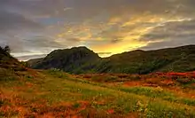
Geography
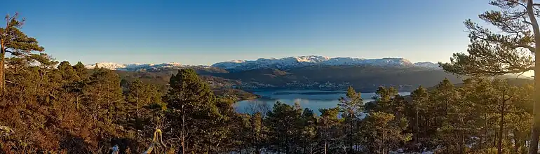
Samnanger lies at the inner end of the Samnangerfjorden. Bjørnafjorden Municipality lies to the south, Bergen Municipality is to the west, Vaksdal Municipality is to the north, and Kvam Municipality is to the east. Samnanger lies on the mainland of Norway, but its western parts lie on the Bergen Peninsula—a large peninsula connected to the mainland by a small isthmus of land running between Trengereid in Bergen and Trengereidfjorden in Samnanger.
The Gullfjellet mountains lie along the western border of the municipality. The mountain Sveningen lies at the tripoint border with Samnanger, Bergen, and Bjørnafjorden municipalities. The Kvamskogen mountain plateau lies along the eastern border of the municipality.
Population
| Historical population | ||||||||||||||
|---|---|---|---|---|---|---|---|---|---|---|---|---|---|---|
| Year | 1907 | 1910 | 1920 | 1930 | 1946 | 1951 | 1960 | 1970 | 1980 | 1990 | 2000 | 2010 | 2020 | 2023 |
| Pop. | 3,025 | 3,025 | 2,664 | 2,588 | 2,440 | 2,503 | 2,493 | 2,180 | 2,305 | 2,412 | 2,282 | 2,375 | 2,485 | 2,495 |
| ±% p.a. | — | +0.00% | −1.26% | −0.29% | −0.37% | +0.51% | −0.04% | −1.33% | +0.56% | +0.45% | −0.55% | +0.40% | +0.45% | +0.13% |
| Source: Statistics Norway[31][32] and Norwegian Historical Data Centre[33] | ||||||||||||||
Notable people
- Knud Langeland (1813–1886), an American editor, farmer, and politician; emigrated in 1843
- Gustav Indrebø (1889–1942), a Norwegian philologist who was interested in toponymy
- Jarle Høysæter (1933–2017), a Norwegian journalist who worked with NRK and Eurovision
References
- "Navn på steder og personer: Innbyggjarnamn" (in Norwegian). Språkrådet.
- "Forskrift om målvedtak i kommunar og fylkeskommunar" (in Norwegian). Lovdata.no.
- Statistisk sentralbyrå. "Table: 06913: Population 1 January and population changes during the calendar year (M)" (in Norwegian).
- Statistisk sentralbyrå. "09280: Area of land and fresh water (km²) (M)" (in Norwegian).
- Fjelltveit, Ingvild; Raunholm, Per Vidar (20 December 2016). "Foreslår å legge ned 17 lensmannskontor i Vest politidistrikt". NRK Hordaland (in Norwegian). Retrieved 20 October 2017.
- Jukvam, Dag (1999). Historisk oversikt over endringer i kommune- og fylkesinndelingen (PDF) (in Norwegian). Statistisk sentralbyrå. ISBN 9788253746845.
- Store norske leksikon. "Samnanger" (in Norwegian). Retrieved 13 July 2014.
- Rygh, Oluf (1910). Norske gaardnavne: Søndre Bergenhus amt (in Norwegian) (11 ed.). Kristiania, Norge: W. C. Fabritius & sønners bogtrikkeri. pp. 186 and 221.
- "Civic heraldry of Norway - Norske Kommunevåpen". Heraldry of the World. Retrieved 22 May 2023.
- "Samnanger, Hordaland". Flags of the World. Retrieved 22 May 2023.
- "Godkjenning av våpen og flagg". Lovdata.no (in Norwegian). Norges kommunal- og arbeidsdepartementet. 30 June 1990. Retrieved 22 May 2023.
- Hansen, Tore; Vabo, Signy Irene, eds. (20 September 2022). "kommunestyre". Store norske leksikon (in Norwegian). Kunnskapsforlaget. Retrieved 14 October 2022.
- "Tall for Norge: Kommunestyrevalg 2019 - Vestland". Valg Direktoratet. Retrieved 2 February 2020.
- "Table: 04813: Members of the local councils, by party/electoral list at the Municipal Council election (M)" (in Norwegian). Statistics Norway.
- "Tall for Norge: Kommunestyrevalg 2011 - Hordaland". Valg Direktoratet. Retrieved 2 February 2020.
- "Kommunestyrevalget 1995" (PDF) (in Norwegian). Oslo-Kongsvinger: Statistisk sentralbyrå. 1996. Retrieved 20 February 2020.
- "Kommunestyrevalget 1991" (PDF) (in Norwegian). Oslo-Kongsvinger: Statistisk sentralbyrå. 1993. Retrieved 20 February 2020.
- "Kommunestyrevalget 1987" (PDF) (in Norwegian). Oslo-Kongsvinger: Statistisk sentralbyrå. 1988. Retrieved 20 February 2020.
- "Kommunestyrevalget 1983" (PDF) (in Norwegian). Oslo-Kongsvinger: Statistisk sentralbyrå. 1984. Retrieved 20 February 2020.
- "Kommunestyrevalget 1979" (PDF) (in Norwegian). Oslo: Statistisk sentralbyrå. 1979. Retrieved 20 February 2020.
- "Kommunevalgene 1975" (PDF) (in Norwegian). Oslo: Statistisk sentralbyrå. 1977. Retrieved 10 May 2020.
- "Kommunevalgene 1972" (PDF) (in Norwegian). Oslo: Statistisk sentralbyrå. 1973. Retrieved 10 May 2020.
- "Kommunevalgene 1967" (PDF) (in Norwegian). Oslo: Statistisk sentralbyrå. 1967. Retrieved 10 May 2020.
- "Kommunevalgene 1963" (PDF) (in Norwegian). Oslo: Statistisk sentralbyrå. 1964. Retrieved 10 May 2020.
- "Kommunevalgene og Ordførervalgene 1959" (PDF) (in Norwegian). Oslo: Statistisk sentralbyrå. 1960. Retrieved 10 May 2020.
- "Kommunevalgene og Ordførervalgene 1955" (PDF) (in Norwegian). Oslo: Statistisk sentralbyrå. 1957. Retrieved 10 May 2020.
- "Kommunevalgene og Ordførervalgene 1951" (PDF) (in Norwegian). Oslo: Statistisk sentralbyrå. 1952. Retrieved 10 May 2020.
- "Kommunevalgene og Ordførervalgene 1947" (PDF) (in Norwegian). Oslo: Statistisk sentralbyrå. 1948. Retrieved 10 May 2020.
- "Kommunevalgene og Ordførervalgene 1945" (PDF) (in Norwegian). Oslo: Statistisk sentralbyrå. 1947. Retrieved 10 May 2020.
- "Kommunevalgene og Ordførervalgene 1937" (PDF) (in Norwegian). Oslo: Statistisk sentralbyrå. 1938. Retrieved 10 May 2020.
- Statistisk sentralbyrå. "Table: 06913: Population 1 January and population changes during the calendar year (M)" (in Norwegian).
- Statistisk sentralbyrå. "Folketellingen 1960" (PDF) (in Norwegian).
- Universitetet i Tromsø – Norges arktiske universitet. "Censuses in the Norwegian Historical Data Archive (NHDC)".
External links
- Municipal fact sheet from Statistics Norway (in Norwegian)
| |||
 | Towns and cities |  | |
| Municipalities | |||