Codajás
Codajás is a municipality located in the Brazilian state of Amazonas. Its population was 29,168 (2020)[1] and its area is 18,712 km².[2]
Codajás | |
|---|---|
 Flag  Seal | |
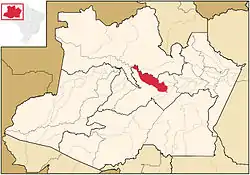
 Location of the municipality inside Amazonas | |
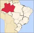
 Location in Brazil | |
| Coordinates: 3°50′13″S 62°3′25″W | |
| Country | |
| Region | North |
| State | |
| Area | |
| • Total | 18,712 km2 (7,225 sq mi) |
| Population (2020) | |
| • Total | 29,168 |
| • Density | 1.1/km2 (3/sq mi) |
| Time zone | UTC−4 (AMT) |
| Climate | Af |
| Website | http://www.ale.am.gov.br/codajas/ |
Geography
The municipality contains part of the Amanã Sustainable Development Reserve.[3]
Climate
| Climate data for Codajás (1981–2010, extremes 1976–present) | |||||||||||||
|---|---|---|---|---|---|---|---|---|---|---|---|---|---|
| Month | Jan | Feb | Mar | Apr | May | Jun | Jul | Aug | Sep | Oct | Nov | Dec | Year |
| Record high °C (°F) | 37.5 (99.5) |
37.0 (98.6) |
38.0 (100.4) |
36.2 (97.2) |
36.1 (97.0) |
35.6 (96.1) |
36.2 (97.2) |
38.2 (100.8) |
39.0 (102.2) |
38.3 (100.9) |
38.6 (101.5) |
36.5 (97.7) |
39.0 (102.2) |
| Average high °C (°F) | 31.8 (89.2) |
31.6 (88.9) |
31.5 (88.7) |
31.3 (88.3) |
31.2 (88.2) |
31.4 (88.5) |
32.2 (90.0) |
33.1 (91.6) |
33.3 (91.9) |
33.3 (91.9) |
32.8 (91.0) |
32.0 (89.6) |
32.1 (89.8) |
| Daily mean °C (°F) | 26.3 (79.3) |
26.4 (79.5) |
26.2 (79.2) |
26.4 (79.5) |
26.4 (79.5) |
26.2 (79.2) |
26.4 (79.5) |
26.8 (80.2) |
27.0 (80.6) |
27.1 (80.8) |
27.1 (80.8) |
26.5 (79.7) |
26.6 (79.9) |
| Average low °C (°F) | 22.7 (72.9) |
22.5 (72.5) |
22.5 (72.5) |
22.6 (72.7) |
22.5 (72.5) |
22.0 (71.6) |
21.5 (70.7) |
21.7 (71.1) |
22.2 (72.0) |
22.8 (73.0) |
22.9 (73.2) |
22.8 (73.0) |
22.4 (72.3) |
| Record low °C (°F) | 15.6 (60.1) |
13.4 (56.1) |
14.5 (58.1) |
17.0 (62.6) |
17.4 (63.3) |
16.0 (60.8) |
12.4 (54.3) |
14.7 (58.5) |
17.1 (62.8) |
14.0 (57.2) |
16.8 (62.2) |
15.8 (60.4) |
12.4 (54.3) |
| Average precipitation mm (inches) | 332.5 (13.09) |
356.4 (14.03) |
422.9 (16.65) |
402.4 (15.84) |
297.4 (11.71) |
158.1 (6.22) |
108.4 (4.27) |
91.7 (3.61) |
136.5 (5.37) |
186.0 (7.32) |
231.8 (9.13) |
346.3 (13.63) |
3,070.4 (120.88) |
| Average precipitation days (≥ 1.0 mm) | 21 | 19 | 22 | 19 | 19 | 13 | 10 | 8 | 11 | 13 | 14 | 19 | 188 |
| Average relative humidity (%) | 84.7 | 84.9 | 84.7 | 85.3 | 84.8 | 83.3 | 82.4 | 82.0 | 81.4 | 82.5 | 83.5 | 84.0 | 83.6 |
| Mean monthly sunshine hours | 134.2 | 104.4 | 118.6 | 119.2 | 134.1 | 163.9 | 211.6 | 211.8 | 188.7 | 167.3 | 149.8 | 132.5 | 1,836.1 |
| Source 1: Instituto Nacional de Meteorologia[4] | |||||||||||||
| Source 2: Meteo Climat (record highs and lows)[5] | |||||||||||||
References
- IBGE 2020
- IBGE - "Archived copy". Archived from the original on 2008-06-11. Retrieved 2008-06-11.
{{cite web}}: CS1 maint: archived copy as title (link) - RDS Amanã (in Portuguese), ISA: Instituto Socioambiental, retrieved 2016-05-05
- "Normais Climatológicas Do Brasil 1981–2010" (in Portuguese). Instituto Nacional de Meteorologia. Retrieved 26 October 2018.
- "Station Codajas" (in French). Meteo Climat. Retrieved 26 October 2018.
This article is issued from Wikipedia. The text is licensed under Creative Commons - Attribution - Sharealike. Additional terms may apply for the media files.
