County of Bowen
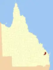
The County of Bowen is a county (a cadastral division) in Queensland, Australia, located in the Wide Bay–Burnett region to the west of Bundaberg. It was named in honour of Sir George Ferguson Bowen, the first Governor of Queensland.[1][2] On 7 March 1901, the Governor issued a proclamation legally dividing Queensland into counties under the Land Act 1897.[3] Its schedule described Bowen thus:
Bounded on the east by the county of Cook; on the south by the county of Mackenzie; on the west by [...] the parishes of Mundowran, Boomerang, Binjour, Jonday, Yenda, Wolca, Wombah, Kolonga and Toweran; and on the north by the northern boundaries of the parishes of Toweran, Kolonga and Manduran.
| Bowen Queensland | |||||||||||||||
|---|---|---|---|---|---|---|---|---|---|---|---|---|---|---|---|
 Location within Queensland | |||||||||||||||
| |||||||||||||||
Parishes
Bowen is divided into parishes, as listed below:
References
- "Bowen (entry 4101)". Queensland Place Names. Queensland Government. Retrieved 8 September 2015.
- Wide Bay/Burnett Districts, County of Bowen Maps – D2 Series at Queensland Archives.
- "A Proclamation". Queensland Government Gazette. Vol. 75. 8 March 1901. pp. 967–980.
External links
This article is issued from Wikipedia. The text is licensed under Creative Commons - Attribution - Sharealike. Additional terms may apply for the media files.