Mount Perry, Queensland
Mount Perry is a rural town and locality in the North Burnett Region, Queensland, Australia.[2][3] In the 2016 census, the locality of Mount Perry had a population of 538 people.[1]
| Mount Perry Queensland | |||||||||||||||
|---|---|---|---|---|---|---|---|---|---|---|---|---|---|---|---|
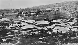 View of Mount Perry, 1907 | |||||||||||||||
 Mount Perry | |||||||||||||||
| Coordinates | 25.1802°S 151.6458°E | ||||||||||||||
| Population | 538 (2016 census)[1] | ||||||||||||||
| • Density | 0.8839/km2 (2.2892/sq mi) | ||||||||||||||
| Postcode(s) | 4671 | ||||||||||||||
| Area | 608.7 km2 (235.0 sq mi) | ||||||||||||||
| Time zone | AEST (UTC+10:00) | ||||||||||||||
| Location | |||||||||||||||
| LGA(s) | North Burnett Region | ||||||||||||||
| State electorate(s) | Callide | ||||||||||||||
| Federal division(s) | Flynn | ||||||||||||||
| |||||||||||||||
The neighbourhood of Drummers Creek is in the locality (25.1500°S 151.6500°E).[4]
Geography
The Perry Fault, a major regional strike-slip structure in South East Queensland is in the New England Orogenic Belt.[5][6]
Mount Perry is about 365 kilometres (227 mi) northwest of Brisbane, the capital of Queensland, and about 100 kilometres (62 mi) west of Bundaberg. The town is nestled in a valley near Mount Perry, the area's highest mountain. The Normanby Lookout is located on Normanby Range Road off Towns Creek Road from the Gin Gin-Mount Perry Road and offers views of the Mount Perry Township and the surrounding countryside. Schuh’s Lookout is on Schuhs Lookout Road off the Monto-Mount Perry Road at the top of the range, offering views south of Mount Perry.[7]
History
Gureng Gureng (also known as Gooreng Gooreng, Goreng Goreng, Goeng, Gurang, Goorang Goorang, Korenggoreng) is an Australian Aboriginal language spoken by the Gureng Gureng people. The Gooreng Gooreng language region includes the towns of Bundaberg, Gin Gin and Miriam Vale extending south towards Childers, inland to Monto and Mt Perry.[8]
The locality takes its name from Mount Perry pastoral run which was named in 1857. Originally there were two private towns known as Fife-Barnett and the town of Tenningering. Tenningering was renamed Mount Perry on 14 January 1915.[2]
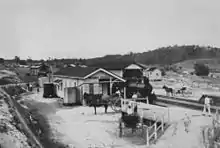
In 1869, copper was discovered at Mount Perry (approx 100 km west of Bundaberg) and the township grew rapidly.[9] A railway to the coast was essential to provide cheap transport and make the mining of low percentage ore viable. Maryborough and Bundaberg vied for the opportunity to be the terminus and the latter city was successful. The first 65 kilometres (40 mi) section of the Mount Perry railway line from North Bundaberg railway station (originally called Bundaberg station) to Moolboolaman opened on 19 July 1881.[10]
Mount Perry Provisional School opened on 7 October 1871 with 36 students. It became Mount Perry State School on 9 February 1874.[11]
Mount Perry Post Office opened on 26 July 1871. It was known as Tenningering between 1882 and 1884.[12][13][14]
Mount Perry Wesleyan Methodist Church opened on Sunday 21 July 1872.[15][16] It was built from timber at a cost of £220. It could seat 120 people. It has closed and been converted into a wedding chapel. It is at 11 Isabella Street (25.177508°S 151.6439°E).[17]
St Patrick's Catholic Church was built in 1873.[18] A Catholic day school opened at the church under teacher Miss Bertheau.[19] A second St Patrick's Church was built in 1904 from timber on the site of the earlier church, which had sold for removal.[20][21] The architect was F H Faircloth and the builder was John Guthrie.[22] Although the church was to be opened on Sunday 12 February 1905 by Archbishop Robert Dunne, he was unable to attend on the day and the church was officially opened by the local priest Father Mimnagh with over 400 people in attendance.[23][24]
Drummer's Creek Provisional School opened on 5 April 1880. On 1 January 1909, it became Drummer's Creek State School. It closed in 1959.[11] It was at 1 School Lane (25.1404°S 151.6253°E).[25]
Mount Perry was connected by the Mount Perry railway line to Bundaberg from 1884 until 1960.[26]
St Anne's Anglican Church was built in 1903. It could seat 100 people.[27]
Mount Perry Presbyterian Church was opened on Wednesday 17 June 1908 by the Reverend Andrew Gillison.[28] It has since been demolished.[29]
Harpur's Hill Provisional School opened on 1908 and closed circa 1909.[30] It reopened in 1917, became Harpur's Hill State School, and closed permanently circa 1924.[11] It was on a 2-acre (0.81 ha) site on the western side of Homestead Road (25.1382°S 151.5645°E) and served a mining community.[30][31][32][33]
At the 2006 census, Mount Perry had a population of 431 people.[34]
At the 2011 census, Mount Perry had a population of 480 people.[35]
In the 2016 census, the locality of Mount Perry had a population of 538 people.[1]
Heritage listings
.jpg.webp)
Mount Perry has a number of heritage-listed sites, including:
- off Flora Street: Mount Perry Copper Smelter[36]
- Heusman Street: Mount Perry Cemetery[36]
- Isabella Street: Mount Perry Masonic Lodge[36][37]
- Sandy Camp Road (north of Magazine Road): Mount Perry Powder Magazine[38]
- 18 Pearson Street: St Patricks Church[36][20]
Economy
Mount Perry is a rural farming area, primarily for raising cattle. Gold mining continues as an important industry. Evolution Mining owns and operates Mt Rawdon Mine which is a gold and silver mine with annual community tours.[9]
Education
Mount Perry State School is a government primary (Early Childhood-6) school for boys and girls at Annie Street (25.1823°S 151.6431°E).[39][40] In 2018, the school had an enrolment of 52 students with 7 teachers (5 full-time equivalent) and 10 non-teaching staff (4 full-time equivalent).[41]
There are no secondary schools in Mount Perry. The nearest government secondary schools are Gin Gin State High School in Gin Gin to the north-east and Burnett State College in Gayndah to the south. However, some parts of Mount Perry are too distant to attend these schools; the alternatives are distance education and boarding school.[42]
Amenities
There is a government-run health centre and a 9-hole golf course. There is a general store, petrol station and post office (with bank agency), motel and a hotel.
The North Burnett Regional Council operates a public library at 34 Heusman Street.[43]
The Mount Perry branch of the Queensland Country Women's Association meets at 73 Heusman Street.[44]
St Patrick's Catholic Church is at 18 Pearson Street (25.179999°S 151.642°E).[45][46]
St Anne's Anglican Church is at 99 Heusman Street (25.177599°S 151.643°E).[27][47]
The Mount Perry Race Club runs horse racing events.
Attractions
Mount Perry has historic copper workings.[9]
Mount Perry has an art gallery and a bicentennial museum with active historic gold stamper (demonstrations on request).
An 18 km section of the Bicentennial National Trail passes through the Mount Perry area and is ideal for walking, cycling or horse riding activities.
There are two lookouts in Mount Perry:
- Normanby Range Lookout at the end of Normanby Range Road (25.1684°S 151.6276°E)[48]
- Schuh's Lookout on the Monto Mount Perry Road (25.1901°S 151.6251°E)[48]
Notable people
- Florence Broadhurst (1899 – 1977), Australian wallpaper and fabrics designer was born in Mount Perry[49]
- Constance Keys, World War I nurse, was born in Mount Perry[50]
- George Martens, Member of the Australia House of Representatives, was born in Mount Perry
- Harold George Nelson, Member of the Australian House of Representatives worked in Mount Perry
See also
References
- Australian Bureau of Statistics (27 June 2017). "Mount Perry (SSC)". 2016 Census QuickStats. Retrieved 20 October 2018.
- "Mount Perry – town in North Burnett Region (entry 44226)". Queensland Place Names. Queensland Government. Retrieved 14 August 2022.
- "Mount Perry – locality in North Burnett Region (entry 45395)". Queensland Place Names. Queensland Government. Retrieved 14 August 2022.
- "Drummers Creek – unbounded locality in the Bundaberg Region (entry 39251)". Queensland Place Names. Queensland Government. Retrieved 23 February 2020.
- Jessop, K.; Daczko, N. R.; Piazolo, S. (19 May 2019). "Tectonic cycles of the New England Orogen, eastern Australia: A Review". Australian Journal of Earth Sciences. 66 (4): 459–496. doi:10.1080/08120099.2018.1548378. ISSN 0812-0099. Archived from the original on 16 October 2019.
- "EMX Royalty Continues to Expand its Portfolio of Australian Gold Projects and Royalties". EMX Royalty Corp. 26 April 2021. Retrieved 13 October 2022.
- "Mount Perry - Scenic Drives". Archived from the original on 19 October 2018. Retrieved 20 October 2018.
- "Gureng Gureng". State Library of Queensland. 21 January 2020.
- Ashley, P.M.; Lottermoser, B.G.; Chubb, A.J. (November 2003). "Environmental geochemistry of the Mt Perry copper mines area,SE Queensland, Australia". Geochemistry: Exploration, Environment, Analysis. 3 (4): 345–357. doi:10.1144/1467-7873/03-014. ISSN 1467-7873.
- "LOCAL OPTION". The Week. Vol. XII, no. 291. Queensland, Australia. 23 July 1881. p. 15. Retrieved 3 March 2022 – via National Library of Australia.
- Queensland Family History Society (2010), Queensland schools past and present (Version 1.01 ed.), Queensland Family History Society, ISBN 978-1-921171-26-0
- "Post Office Details - Mount Perry (1)". Phoenix Auctions. Retrieved 10 May 2014.
- "Post Office Details - Tenningering". Phoenix Auctions. Retrieved 3 March 2022.
- "Post Office Details - Mount Perry (2)". Phoenix Auctions. Retrieved 3 March 2022.
- "(From the Rockhampton Bulletin.)". Maryborough Chronicle, Wide Bay and Burnett Advertiser. No. 1244. Queensland, Australia. 27 July 1872. p. 2. Retrieved 7 November 2022 – via National Library of Australia.
- "OXLEY". The Brisbane Courier. Vol. XXVII, no. 4, 632. Queensland, Australia. 3 August 1872. p. 5. Retrieved 7 November 2022 – via National Library of Australia.
- Blake, Thom. "Mount Perry Methodist Church". Queensland religious places database. Retrieved 22 September 2022.
- Blake, Thom. "St Patrick's Catholic Church (1873)". Queensland religious places database. Retrieved 22 September 2022.
- "NOTHINGS FROM THE PAPERS". Maryborough Chronicle, Wide Bay and Burnett Advertiser. No. 1330. Queensland, Australia. 13 February 1873. p. 2. Retrieved 7 November 2022 – via National Library of Australia.
- "St Patricks Church (entry 600764)". Queensland Heritage Register. Queensland Heritage Council. Retrieved 12 July 2013.
- "MOUNT PERRY". Maryborough Chronicle, Wide Bay and Burnett Advertiser. No. 9900. Queensland, Australia. 27 August 1904. p. 4. Retrieved 7 November 2022 – via National Library of Australia.
- Blake, Thom. "St Patrick's Catholic Church (1904)". Queensland religious places database. Retrieved 22 September 2022.
- "MOUNT PERRY". Maryborough Chronicle, Wide Bay and Burnett Advertiser. No. 10, 037. Queensland, Australia. 3 February 1905. p. 3. Retrieved 23 August 2016 – via National Library of Australia.
- "MOUNT PERRY". Maryborough Chronicle, Wide Bay and Burnett Advertiser. No. 10, 049. Queensland, Australia. 17 February 1905. p. 4. Retrieved 23 August 2016 – via National Library of Australia.
- "Queensland Two Mile series sheet 2m158" (Map). Queensland Government. 1952. Retrieved 6 November 2022.
- Rails to Mount Perry Milne, Rod Australian Railway Historical Society Bulletin, August, 1998 pp294-301
- Blake, Thom. "St Anne's Anglican Church". Queensland religious places database. Retrieved 22 September 2022.
- "REV. A. GILLISON". The Bundaberg Mail And Burnett Advertiser. No. 3520. Queensland, Australia. 9 June 1908. p. 2. Retrieved 7 November 2022 – via National Library of Australia.
- Blake, Thom. "Mount Perry Presbyterian Church". Queensland religious places database. Retrieved 22 September 2022.
- "MOUNT PERRY". The Bundaberg Mail And Burnett Advertiser. No. 3519. Queensland, Australia. 8 June 1908. p. 3. Retrieved 7 November 2022 – via National Library of Australia.
- "County of Bowen" (Map). Queensland Government. 1923. Retrieved 7 November 2022.
- "Parish of Wolca" (Map). Queensland Government. 1973. Retrieved 7 November 2022.
- "DRUMMER'S CREEK". The Bundaberg Mail. Vol. 49, no. 6856. Queensland, Australia. 12 September 1919. p. 6. Retrieved 7 November 2022 – via National Library of Australia.
- Australian Bureau of Statistics (25 October 2007). "Mount Perry (Perry Shire) (State Suburb)". 2006 Census QuickStats. Retrieved 5 July 2008.
- Australian Bureau of Statistics (31 October 2012). "Mount Perry (SSC)". 2011 Census QuickStats. Retrieved 22 August 2016.
- "North Burnett Local Heritage Register" (PDF). North Burnett Regional Council. Archived (PDF) from the original on 16 August 2019. Retrieved 16 August 2019.
- "Masonic Lodge (entry 600765)". Queensland Heritage Register. Queensland Heritage Council. Retrieved 12 July 2013.
- "Mount Perry Powder Magazine (entry 602782)". Queensland Heritage Register. Queensland Heritage Council. Retrieved 12 July 2013.
- "State and non-state school details". Queensland Government. 9 July 2018. Archived from the original on 21 November 2018. Retrieved 21 November 2018.
- "Mount Perry State School". Mount Perry State School. 16 January 2020. Retrieved 6 November 2022.
- "ACARA School Profile 2018". Australian Curriculum, Assessment and Reporting Authority. Retrieved 28 January 2020.
- "Queensland Globe". State of Queensland. Retrieved 6 November 2022.
- "Library Services". Gympie Regional Council. Archived from the original on 31 January 2018. Retrieved 31 January 2018.
- "Branch Locations". Queensland Country Women's Association. Archived from the original on 26 December 2018. Retrieved 26 December 2018.
- Blake, Thom. "St Patrick's Catholic Church". Queensland religious places database. Retrieved 22 September 2022.
- "Service Times | Sacred Heart Catholic Church". Catholic Childers. Retrieved 7 November 2022.
- "Anglican Parish of Gayndah". Anglican Parish of Gayndah. Retrieved 7 November 2022.
- "Tourist points - Queensland". Queensland Open Data. Queensland Government. 18 November 2020. Archived from the original on 24 November 2020. Retrieved 24 November 2020.
- Van de Ven, Anne-Marie (2005). "Broadhurst, Florence Maud (1899–1977)". Australian Dictionary of Biography. Archived from the original on 5 April 2018. Retrieved 15 April 2018.
- Merrillees, P. H.; Merrillees, R. S., "Keys, Constance Mabel (1886–1964)", Australian Dictionary of Biography, Canberra: National Centre of Biography, Australian National University, retrieved 7 November 2022