Cania, Queensland
Cania is a locality in the North Burnett Region, Queensland, Australia.[2] In the 2021 census, Cania had a population of 27 people.[3]
| Cania Queensland | |||||||||||||||
|---|---|---|---|---|---|---|---|---|---|---|---|---|---|---|---|
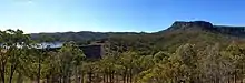
 Dragon Cave, Cania Gorge National Park | |||||||||||||||
 Cania | |||||||||||||||
| Coordinates | 24.5816°S 150.9941°E | ||||||||||||||
| Population | 27 (SAL 2021)[1] | ||||||||||||||
| Postcode(s) | 4630 | ||||||||||||||
| Area | 471.1 km2 (181.9 sq mi) | ||||||||||||||
| Time zone | AEST (UTC+10:00) | ||||||||||||||
| Location | |||||||||||||||
| LGA(s) | North Burnett Region | ||||||||||||||
| State electorate(s) | Callide | ||||||||||||||
| Federal division(s) | Flynn | ||||||||||||||
| |||||||||||||||
Geography
Three Moon Creek rises in the north of the locality (24.39831°S 151.04558°E) and flows south through the locality into Lake Cania, created by the Cania Dam in the south of the locality (24.65004°S 150.98592°E).[4]
There are a number of protected areas in Cania:[5]
- Cania Gorge National Park in the south of the locality
- part of Kroombit Tops National Park in the north of the locality
- part of Grevillea State Forest in the west of the locality
History
Thomas Archer was the first European to explore the headwaters of the Burnett River in the 1840s.[6]
Cania pastoral station was established in the 1850s raising sheep until 1883, after which beef and dairy cattle were added.[7]
Gold was discovered in the Cania Gorge in 1870.[8] The gold mining town of Cania was established near Three Moon Creek and gold mining continued there until the early 1920s.[7]
Cania Provisional School opened in 1890. It became Cania State School on 1 January 1909. Due to low attendance numbers, it closed in 1930.[9]
The construction of the Cania Dam across Three Moon Creek in 1982 flooded the former town of Cania. However, headstones from the town's cemetery were relocated to the dam lookout.[10] At low water levels, the tops of the some of the town's buildings become visible, which last occurred in 2010.[7]
Demographics
In the 2016 census, Cania had a population of 28 people.[11]
In the 2021 census, Cania had a population of 27 people.[3]
Education
There are no schools in Cania. The nearest government primary school is Monto State School in Monto to the south-east. The nearest government secondary school is Monto State High School, also in Monto. However, some parts of Cania are too far from Monto for a daily commute, so distance education and boarding school are other options.[5]
Amenities
There is boat ramp into the Cania Dam (24.6477°S 150.9820°E). It is managed by the North Burnett Regional Council.[12]
Attractions
There are numerous lookouts in Cania:
- Castle Mountain Lookout (24.6535°S 150.9973°E)[13]
- Giants Chair Lookout (24.7220°S 150.9842°E)[13]
- Big Foot Lookout (24.7236°S 150.9926°E)[13]
- Bloodwood Cave Lookout (24.7180°S 150.9941°E)[13]
- Gorge Lookout (24.7167°S 150.9932°E)[13]
- Dragon Cave Lookout (24.7161°S 150.9928°E)[13]
- The Lookout (24.7109°S 150.9944°E)[13]
- Dripping Rock Lookout (24.7107°S 150.9946°E)[13]
- The Overhang Lookout (24.7077°S 150.9966°E)[13]
- Cania Dam Lookout (24.65270°S 150.98280°E)[10]
References
- Australian Bureau of Statistics (28 June 2022). "Cania (Suburb and Locality)". Australian Census 2021 QuickStats. Retrieved 28 June 2022.
- "Cania – locality in North Burnett Region (entry 45327)". Queensland Place Names. Queensland Government. Retrieved 30 March 2019.
- Australian Bureau of Statistics (28 June 2022). "Cania (SAL)". 2021 Census QuickStats. Retrieved 28 February 2023.
- Google (29 July 2019). "Cania, Queensland" (Map). Google Maps. Google. Retrieved 29 July 2019.
- "Queensland Globe". State of Queensland. Retrieved 27 August 2023.
- Mennell, Philip (1892). . The Dictionary of Australasian Biography. London: Hutchinson & Co – via Wikisource.
- "Cania Gorge & National Park - Monto Magic". 8 March 2017. Archived from the original on 24 March 2023. Retrieved 27 August 2023.
- "MINING". Maryborough Chronicle, Wide Bay And Burnett Advertiser. No. 895. Queensland, Australia. 30 April 1870. p. 3. Archived from the original on 27 August 2023. Retrieved 28 August 2023 – via National Library of Australia.
- Queensland Family History Society (2010), Queensland schools past and present (Version 1.01 ed.), Queensland Family History Society, ISBN 978-1-921171-26-0
- "Cania Dam". Sunwater. Archived from the original on 20 March 2023. Retrieved 27 August 2023.
- Australian Bureau of Statistics (27 June 2017). "Cania (SSC)". 2016 Census QuickStats. Retrieved 20 October 2018.
- "Recreational Boating Facilities Queensland". Queensland Open Data. Queensland Government. 12 November 2020. Archived from the original on 22 November 2020. Retrieved 22 November 2020.
- "Tourist points - Queensland". Queensland Open Data. Queensland Government. 18 November 2020. Archived from the original on 24 November 2020. Retrieved 24 November 2020.
Further reading
- Bleys, Beryl; Bleys, Cecil (2005). Cania diggings : goldfield memories. Monto History Centre.
- Pullar, Ian; Cook, Margaret (2001). Watery sauces: a people’s history of the Water Resources Commission (Queensland) and its predecessors 1881-1995. Dept. of Natural Resources and Mines. ISBN 0734517874.