Crosby Villa
Crosby Villa is a hamlet in the civil parish of Crosscanonby in Cumbria, United Kingdom. It is located on the A596 road, 3.75 miles (6.04 km) north-east of Maryport and 3.75 miles (6.04 km) south-west of Aspatria. The village of Crosby is 1.5 miles (2.4 km) to the south-west, and the hamlet of Oughterside is 2.25 miles (3.62 km) to the north-east. Cumbria's county town, Carlisle, is 24 miles (39 km) to the north-east.[1]
| Crosby Villa | |
|---|---|
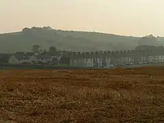
 Crosby Villa from across the fields. | |
| OS grid reference | NY091390 |
| Civil parish | |
| Unitary authority | |
| Ceremonial county | |
| Region | |
| Country | England |
| Sovereign state | United Kingdom |
| Post town | Maryport |
| Postcode district | CA15 |
| Dialling code | 01900 |
| Police | Cumbria |
| Fire | Cumbria |
| Ambulance | North West |
| UK Parliament | |
Crosby Villa lies on the Solway Plain, less than 1 mile (1.6 km) from the boundary of the Solway Coast Area of Outstanding Natural Beauty,[2] and approximately 1.5 miles (2.4 km) s from the shore of Allonby Bay, an inlet of the Solway Firth. Historically, the name may have been spelled Crosby Villas.[3]
Governance
Crosby Villa is in the parliamentary constituency of Workington. In the December 2019 general election, the Tory candidate for Workington, Mark Jenkinson, was elected the MP, overturning a 9.4 per cent Labour majority from the 2017 election to eject shadow environment secretary Sue Hayman by a margin of 4,136 votes.[4] Until the December 2019 general election, the Labour Party had won the seat in every general election since 1979.The Conservative Party had only been elected once in Workington since World War II, at the 1976 by-election.[5] Historically Crosby Villa has been a Labour supporting area.
Before Brexit for the European Parliament its residents voted to elect MEP's for the North West England constituency.
For Local Government purposes it is in the Cumberland unitiary authority area.
Crosby Villa has its own Parish Council; Crosscanonby Parish Council.[6]
History
During the Roman period, there was a settlement near to the site of modern Crosby Villa called Garborough. The modern village was built to provide housing for miners at Rosegill and Bullgill coal mines during the 19th century. In addition to the seventy terraced houses, a chapel, shops, and a post office were provided, along with allotments for gardening. The chapel was built in 1863. There was no school, however, and the miners' children walked to Crosby to attend the school there. Near to Bullgill coal mine was Bullgill railway station, approximately 0.25 miles (0.40 km) from Crosby Villa, on the Maryport and Carlisle Railway (now a part of the Cumbrian Coast Line). Bullgill pit closed in 1897, and Rosegill a few years later. This began a period of hardship for the village, exacerbated by the General Strike of 1926.[7][8] Bullgill railway station closed to passengers in 1960, a few years before the Beeching axe. A road haulage firm called Duncan Hill was established in nearby Dearham in 1951, and later relocated to Crosby Villa, from where it continues to operate.[9]
References
- "Google Maps - Crosby Villa". Retrieved 28 February 2015.
- "Solway Coast AONB - Location". Archived from the original on 5 January 2015. Retrieved 28 February 2015.
- "Forebears - Crosby". Retrieved 1 March 2015.
- "Workington parliamentary constituency – Election 2019".
- "A vision of Britain website – general elections section". Retrieved 27 April 2012.
- "Crosscanonby Parish Council".
- "Forebears - Crosby". Retrieved 1 March 2015.
- "Visitor UK - Crosby". Retrieved 1 March 2015.
- "Duncan Hill". Retrieved 28 February 2015.

