Cyr, Montana
Cyr is an unincorporated community and census-designated place (CDP) in Mineral County, Montana, United States. It is in the southeastern part of the county, in the valley of the Clark Fork. Interstate 90 crosses the community, with partial access from Exit 70. Alberton is 6 miles (10 km) to the east (upriver), while Superior, the Mineral county seat, is 22 miles (35 km) to the northwest (downriver).
Cyr, Montana | |
|---|---|
 Cyr  Cyr | |
| Coordinates: 47°0′27″N 114°34′48″W | |
| Country | United States |
| State | Montana |
| County | Mineral |
| Area | |
| • Total | 1.40 sq mi (3.63 km2) |
| • Land | 1.40 sq mi (3.63 km2) |
| • Water | 0.00 sq mi (0.00 km2) |
| Elevation | 2,963 ft (903 m) |
| Population (2020) | |
| • Total | 63 |
| • Density | 44.97/sq mi (17.36/km2) |
| Time zone | UTC-7 (Mountain (MST)) |
| • Summer (DST) | UTC-6 (MDT) |
| ZIP Code | 59820 (Alberton) |
| Area code | 406 |
| FIPS code | 30-18850 |
| GNIS feature ID | 2806648[2] |
References
- "ArcGIS REST Services Directory". United States Census Bureau. Retrieved September 5, 2022.
- U.S. Geological Survey Geographic Names Information System: Cyr, Montana
- "Census of Population and Housing". Census.gov. Retrieved June 4, 2016.
Municipalities and communities of Mineral County, Montana, United States | ||
|---|---|---|
| Towns | 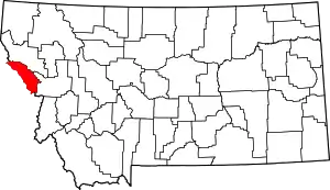 Mineral County map | |
| CDPs | ||
| Unincorporated communities | ||
| Ghost town | ||
This article is issued from Wikipedia. The text is licensed under Creative Commons - Attribution - Sharealike. Additional terms may apply for the media files.