Dame Lane
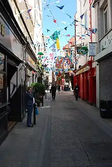
Dame Lane (Irish: Lána an Dáma) is a narrow thoroughfare in Dublin, Ireland, with a variety of historical and literary associations.
 | |
 | |
| Native name | Lána an Dáma (Irish) |
|---|---|
| Namesake | St. Mary del Dam |
| Length | 260 m (850 ft) |
| Width | 8 metres (26 ft) |
| Location | Dublin, Ireland |
| Postal code | D02 |
| Coordinates | 53.343847°N 6.263883°W |
| west end | Palace Street |
| east end | Trinity Street |
| Construction | |
| Inauguration | 1792 |
| Other | |
| Known for | pubs |
Location
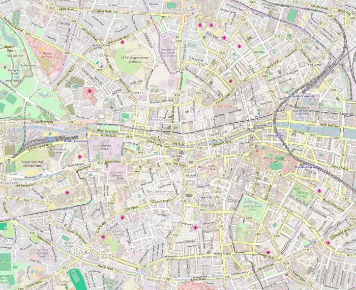
Dame Lane is located in the south of Dublin's historic city centre, parallel to Dame Street. Temple Bar and College Green are found just north of the street. Dame Lane is close to Dublin Castle, St Andrew's Church (now the Dublin Tourism Office) and Trinity College. The lane stretches from Trinity Street, to Palace Street, across South Great George's Street in an east–west direction. It also runs alongside and close to part of the "Dubline", an historic Dublin tourist walking trail that stretches from College Green to Kilmainham.[1]
History
Dame Lane derives its name from the medieval church of St. Mary del Dam, which was demolished in the 17th century. According to some sources,[2][3] the name of the church comes from a Poddle dam that originally gave its name to Dam(e) Street and to the eastern gate of the city of Dublin. These are identified as Damas Street and Damas Gate on John Speed's map of 1610.[4] Speed's map also shows a residential area stretching east from the walled city, the old 12th-century St Andrew's Church, and a semi-circular enclosed graveyard near Palace Street.[3][5] Various spellings appear in different sources and on maps, including Damas, Dammas, Dames, and Dame's.[6]
Dame Street, just to the north, "was the Royal Mile of 18th Century Dublin," linking the castle to the parliament building.[7] Today, Dame Lane dates mainly from the late 18th century, when it was set out as a mews lane as part of the work of the Wide Streets Commission, between 1785 and 1790, in the second phase of its works "for making wide and convenient streets." The section of Dame Lane closest to Dublin Castle follows the line of an older route through the area where the old Castle Market stood, just off what is now South Great George's Street. The re-alignment of this, the oldest part of the existing lane, began in 1782 with the demolition of Castle Market.[8][9] Dame Lane is shown but described as "unnamed" on Brooking's map of 1728, but is identified on Rocque's later map of 1756.[6]
The old Castle Market, dating from around 1707, was developed by Alderman William Fownes and James Pooley, Esq.[10] and built on the site of the churchyard of the old St Andrew's Church. Some time after 1682, the old St. Andrew's graveyard was obliterated with the construction of the market. This market is shown clearly on Rocque's 1756 map. It featured 34 stalls of butchers, cheesemakers and poulterers, and the map: "shows a marketplace connected to George's street by a narrow laneway. It could be entered from Palace St by another short alleyway known as Dame Lane".[11]
From 1785 to 1790, the newer section of Dame Lane, east of George's Street, replaced an earlier medieval street pattern of "tangled plots and lanes between George's Lane and Trinity Street".[12] Trinity Place, a mainly residential lane and square, existed along this lane for many years in the 19th century, but has long since gone. This was to the south of, and accessed directly from, Dame Lane. In 1818, Trinity Place had 172 residents,[13] and later in Thom's Almanac of 1862 "Trinity-place off Dame-Lane" is listed as having 21 houses, many noted as being in tenements. Dame Lane also had some tenements in 1862, as well as a tavern, provision stores, and various other businesses.[14] The spot where Trinity Place once stood, just off Dame Lane, has historic connections with the construction of a bridewell from 1603 (featured on Speed's map) and from 1616 with Trinity College. "In 1660, Trinity Hall (standing or the ground now occupied by Trinity-place), belonging to Trinity College, was set apart as a medical school".[15][16][17][18]
Dame Lane in fiction
Dame Lane is noted for a connection to Hely's Printing Works, once a significant business presence along Dame Court and Dame Lane. Hely's was a prominent and successful Dublin stationer at nearby 27-30 Dame Street,[19] with an associated large printing works located behind their shop premises. The former printing works, called "Hely’s Acme Works," building by William Mansfield Mitchell dates from 1895 to 1896 and still stands.[20][21] The Dame Court and Dame Lane buildings remain today and wrap around the Stag's Head pub. Most significantly, it was a former employer of Joyce's character Leopold Bloom in Ulysses. "He read the scarlet letters on their five tall white hats: H.E.L.Y.S." (U 8.125-6). In the novel, Hely's sandwichboard-men wander Dublin and appear in both "The Lestrygonians" and "Wandering Rocks", episodes 8 and 10.[22] In February 2014 part of Dame Lane was transformed for a few days into Victorian London's Pulteney Lane for the gothic horror drama Penny Dreadful.[23]
Today

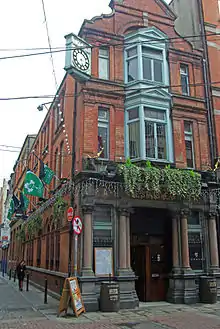
The lane is part of a small area bounded by South Great George's Street and Dame Street. It is branded "Dame District." This is promoted by a group of local businesses in both Dame Court and Dame Lane "as an area for socializing and entertainment."[24] The most significant landmark today on Dame Lane is The Stag's Head, a mostly intact public bar built on the site of older taverns dating from the 1780s. The Stag's Head was re-built in 1895 in "redbrick with Italianate detail" by businessman George Tyson and architect Alfred McGloughlin in high Victorian style with mahogany, stained glass and mirrors. It is "elaborately decorated inside and out."[20] This building sits on the corner of Dame Court and Dame Lane.[3] This replaced an older bar from the 1830s known as John Bull's Albion Hotel and Tavern.[25]
The lane is also notable for the Universal Hair Clinic's "Why Go Bald?" sign on the corner of South Great George's Street, reputedly a favourite Dublin landmark of Bono.[26][27] The sign dates from 1961 and was refurbished by Taylor Signs in 1999, following representations from the Twentieth Century Trust.[3][28] From 2013 to 2018, 5 Dame Lane was the location of Fumbally Exchange, a not-for-profit community of design professionals. The building at No. 5 Dame Lane dates from 1906 and was built as part of an extension to the Hely's Acme Printing Works.[29] Architectural historian Christine Casey refers to the date of 1906 when Batchelor & Hicks used the Hennebique "system of re-inforced concrete framing reputedly employed here for the first time in Dublin". (p. 415)[3] The building was added to the Dublin City Council Record of Protected Structures in 2017.[30]
References
Sources
- Pearson, Peter (2000). The Heart of Dublin: Resurgence of an Historic City. Dublin: O'Brien Press.
Citations
- "Dublin Discovery Trails in Dublin | Visit Dublin". Dubline.ie. Retrieved 31 October 2021.
- Gilbert, JT (1859). A History of the City of Dublin Vol II. Dublin.
{{cite book}}: CS1 maint: location missing publisher (link) - Casey, Christine (2005). Dublin: The City Within the Grand and Royal Canals and the Circular Road with the Phoenix Park. Yale University Press.
- "Archived copy" (PDF). Archived from the original (PDF) on 8 April 2014. Retrieved 8 April 2014.
{{cite web}}: CS1 maint: archived copy as title (link) - Wright, George Newenham, An Historical Guide to the City of Dublin. 2nd edition published London: Baldwin, Cradock and Joy, 1825
- "Dublin 1610 to 1756" (PDF). Logainm.ie. Retrieved 31 October 2021.
- McCullough, Niall, Dublin: An Urban History, Anne Street Press, Dublin, 2001, p.47
- Pearson 2000, p.69
- McCullough, Niall, Dublin: An Urban History, Anne Street Press, Dublin, 2001, p.128
- Harris, Walter, The History and Antiquities of the city of Dublin, from the earliest accounts (1766)
- Pearson 2000, p.68
- McCullough, Niall, Dublin: An Urban History, Anne Street Press, Dublin, 2001, p.75
- J. Whitelaw & R. Walsh, History of the city of Dublin, from the earliest accounts to the present time (2 vols, Dublin, 1818)
- Thom's Irish Almanac and Official Directory for the Year 1862, Dublin (1862)
- Webb, Alfred, A Compendium of Irish Biography, Dublin, M.H. Gill, Sackville St (1878)
- Dublin University Magazine Vol 82 p. 333 (1876), “Trinity Hall, which had been formerly a Bridewell in Trinity Place, off Dame-lane”
- Smith, A., Dublin Journal of Medical Science, Vol. XIX, 1841, pp. 83-87, "It must be fairly be presumed that the exact spot on which it stood is at present occupied by the pile of buildings on the centre of Trinity Place, which probably has derived its name from the Hall"
- Dublin Quarterly Journal of Medical Science, Volume 39, p. 443, "the centre of Trinity Place off Dame Lane, where a quadrangular set of buildings …still exists"
- Nash, John ed., James Joyce in the Nineteenth Century, Cambridge University Press, published September 2013
- Pearson 2000, p.480
- "CO. DUBLIN, DUBLIN, DAME COURT, NO. 002-6 (ACME PRINTING WORKS) Dictionary of Irish Architects -". Dia.ie.
- Joyce, James (1922). Ulysses. Sylvia Beach.
- "Dublin gets Victorian makeover as Penny Dreadful filming continues | Demotix.com". Archived from the original on 6 May 2014. Retrieved 8 April 2014.
- "Dame District Market — in the Heart of Dublin". Archived from the original on 8 April 2014. Retrieved 8 April 2014.
- "Stags Head |Traditional Irish Pub| Live Music| Food| Comedy| Dublin City". Archived from the original on 8 April 2014. Retrieved 8 April 2014.
- "At Taylor Signs we are constantly asked to manufacture and install signs in a variety of sizes and materials. No job is either beneath or beyond the capabilities of our craftsmen". Taylorsigns.ie. Retrieved 31 October 2021.
- "Mr. W.G.B. (Why Go Bald?) a landmark well-known to Dubliners..." Universalclinic.ie. Retrieved 20 March 2014.
- "Sign of the times". The Irish Times.
- "CO. DUBLIN, DUBLIN, DAME STREET, NO. 027-30 (HELY) Dictionary of Irish Architects -". Dia.ie.
- "On whether to accept the council management's | Council Tracker". Counciltracker.ie.
External links
- Video (5:37) Helys Printers Poster Boys for recruitment - BBC Programme on Irish WWI Posters
- Stag’s Head Pub Website Archived 2014-04-08 at the Wayback Machine
- Fumbally Exchange Website
- Story Map Website
- RTE video on Why Go Bald? sign
- CO. DUBLIN, DUBLIN, DAME COURT, NO. 002-6 (ACME PRINTING WORKS) Dictionary of Irish Architects - Dictionary of Irish Architects- refs to Acme Printing Works (1896-1897)
- Hennebique-description Archived 17 November 2012 at the Wayback Machine Hennebique System- after François Hennebique, a French contractor who obtained an English patent in 1892 for his system
- TV listings guide World War I Series on BBC and how Hely's benefitted from the War.
- 7. Dame Court (alley off Dame Lane) Come Here to Me!: Dame Court (alley off Dame Lane)