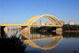
Daniel Carter Beard Bridge
The Daniel Carter Beard Bridge (also known colloquially as the Big Mac Bridge), is a yellow twin span steel bowstring arch bridge crossing the Ohio River in Cincinnati, Ohio. It carries Interstate 471 between Cincinnati, Ohio, and Newport, Kentucky. As to the origin of this nickname, its yellow arches are said to be similar to the "Golden Arches" logo of McDonald's restaurant.[3] The nickname was coined by local residents after the bridge's golden arches were constructed. In the 1980s, McDonald's considered opening a floating restaurant at the base after the nickname caught on, but never went to construction.[4] This bridge has a main span of 750 feet (230 m) and has a total span of 2,100 feet (640 m). It is named in honor of Daniel Carter Beard, the founder of the Sons of Daniel Boone and one of the founders of the Boy Scouts of America.[5]
Daniel Carter Beard Bridge | |
|---|---|
 | |
| Coordinates | 39.1006°N 84.4945°W |
| Carries | 8 lanes of |
| Crosses | Ohio River |
| Locale | Newport, Kentucky and Cincinnati, Ohio |
| Other name(s) | Big Mac Bridge |
| Maintained by | Kentucky Transportation Cabinet[1] |
| Characteristics | |
| Design | Twin bowstring arch bridges |
| Total length | 639.93 meters (2,099.5 feet) |
| Width | 15.27 meters (50.1 feet) |
| Longest span | 230.92 meters (757.6 feet) |
| Clearance above | 5.49 meters (18 feet) |
| History | |
| Construction cost | $14 million[2] |
| Opened | January 1976 (southbound) December 1976 (northbound) |
| Statistics | |
| Daily traffic | 97,900 |
| Location | |
The bridge was originally designed by Hazelet + Erdal, now URS Corporation.
The bridge was originally configured with three lanes and an emergency shoulder on each span. In December 2000, with the completion of a reconstruction project on the 3rd Street Viaduct approach, the bridge was reconfigured to four lanes on each span.
See also
References
- "ArcGIS Web Application".
- "Bridges & Tunnels | Daniel Carter Beard Bridge (Interstate 471)". Archived from the original on 2011-07-11. Retrieved 2011-07-06.
- Pond, Robert J. (May 1, 2003). Follow the Blue Blazes: A Guide To Hiking Ohio's Buckeye Trail. Ohio University Press. p. 93. ISBN 9780821414897. Retrieved 2013-06-02.
- Smith, Steve; et al. (2007). "Around Town: How to Decode Cincinnati's Many Motorways". Cincinnati USA City Guide. Cincinnati Magazine. p. 79. Retrieved 2013-05-06.
- "Bridge to open". Kentucky New Era. October 28, 1976. p. 8. Retrieved 21 April 2016.
External links
- Daniel Carter Beard Bridge at Bridges & Tunnels
- Daniel Carter Beard Bridge at Cincinnati Transit
- Daniel Carter Beard Bridge at Structurae