Dawesville, Western Australia
Dawesville is a suburb of Mandurah, located adjacent to the Peel-Harvey Estuarine System south of Perth in Western Australia. The Dawesville Cut, a man-made canal built in 1994, is to the north of the suburb.
| Dawesville Mandurah, Western Australia | |||||||||||||||
|---|---|---|---|---|---|---|---|---|---|---|---|---|---|---|---|
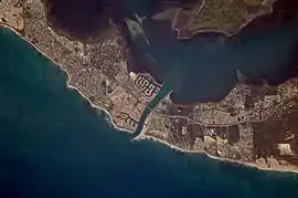 Satellite image of the Dawesville Channel and Dawesville to the south of it, taken by ISS Expedition 17 | |||||||||||||||
| Coordinates | 32°38′56″S 115°38′28″E | ||||||||||||||
| Population | 7,143 (SAL 2021)[1] | ||||||||||||||
| Postcode(s) | 6211 | ||||||||||||||
| Area | 18.5 km2 (7.1 sq mi) | ||||||||||||||
| LGA(s) | City of Mandurah | ||||||||||||||
| State electorate(s) | Dawesville | ||||||||||||||
| Federal division(s) | Canning | ||||||||||||||
| |||||||||||||||
Attractions outside crabbing and fishing include canoeing, jet-ski and skiing, whilst being only 500 metres (1,600 ft) from the beach over the highway is another attraction. Pyramids Beach, the most popular beach in Dawesville, is currently undergoing development of the beach to make it a future surf spot.
History
Dawesville is named after Louis Dawe who was involved in the local fish canning industry in the early 1900s. In 1913 Dawe built the heritage listed "Allandale Homestead" which overlooks the estuary.[2]
References
- Australian Bureau of Statistics (28 June 2022). "Dawesville (Suburb and Locality)". Australian Census 2021 QuickStats. Retrieved 28 June 2022.
- "Allandale Homestead". InHerit. Heritage Council of Western Australia. Retrieved 21 February 2020.
This article is issued from Wikipedia. The text is licensed under Creative Commons - Attribution - Sharealike. Additional terms may apply for the media files.