De Mars, Gelderland
De Mars is a hamlet in the Dutch province of Gelderland. It is a part of the municipality of Buren, and lies about 8 km south of Veenendaal.
De Mars | |
|---|---|
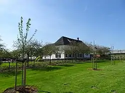 Farm in De Mars | |
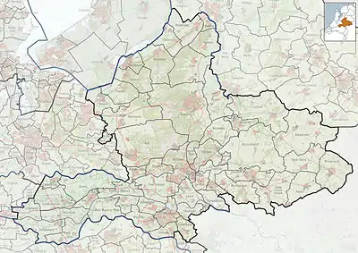 De Mars Location in the province of Gelderland  De Mars De Mars (Netherlands) | |
| Coordinates: 51.95271°N 5.53440°E | |
| Country | Netherlands |
| Province | Gelderland |
| Municipality | Buren |
| Area | |
| • Total | 7.29 km2 (2.81 sq mi) |
| Elevation | 7 m (23 ft) |
| Population (2021)[1] | |
| • Total | 295 |
| • Density | 40/km2 (100/sq mi) |
| Time zone | UTC+1 (CET) |
| • Summer (DST) | UTC+2 (CEST) |
| Postal code | 4033[1] |
| Dialing code | 0344 |
The area belonging to De Mars was originally located north of the Rhine river. However, the river bed now runs along a new route north of De Mars.
It was first mentioned in 1250 as in Marsche, and means "in the marsh".[3] In 1840, it was home to 219 people.[4] The postal authorities have placed it under Lienden.[5]
References
- "Kerncijfers wijken en buurten 2021". Central Bureau of Statistics. Retrieved 21 March 2022.
together with Marsdijk
- "Postcodetool for 4033AA". Actueel Hoogtebestand Nederland (in Dutch). Het Waterschapshuis. Retrieved 21 March 2022.
- "De Mars - (geografische naam)". Etymologiebank (in Dutch). Retrieved 21 March 2022.
- "De Mars (Lienden)". Plaatsengids (in Dutch). Retrieved 21 March 2022.
- "Postcode 4033 in Lienden". Postcode bij adres (in Dutch). Retrieved 21 March 2022.
This article is issued from Wikipedia. The text is licensed under Creative Commons - Attribution - Sharealike. Additional terms may apply for the media files.