Dharmasraya Regency
Dharmasraya Regency is a landlocked regency (kabupaten) of West Sumatra province, Indonesia. It covers an area of 2,961.13 km2 and had a population of 191,422 at the 2010 Census[2] and 228,591 at the 2020 Census;[3] the official estimate as at mid 2022 was 234,713 - comprising 119,505 males and 115,208 females.[1] The administrative centre is the town of Pulau Punjung. In the past, this regency was the location of an independent Kingdom of Dharmasraya, which came to power in the 11th century.
Dharmasraya Regency
Kabupaten Dharmasraya | |
|---|---|
 Coat of arms | |
| Motto: Tau Jo Nan Ampek | |
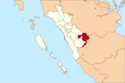 Location within West Sumatra | |
| Coordinates: 1.05°S 101.367°E | |
| Country | Indonesia |
| Province | West Sumatra |
| Regency seat | Pulau Punjung |
| Government | |
| • Regent | Sutan Riska Tuanku Kerajaan |
| • Vice Regent | Amrizal Datuak Rajo Medan |
| Area | |
| • Total | 2,961.13 km2 (1,143.30 sq mi) |
| Population (mid 2022 estimate)[1] | |
| • Total | 234,713 |
| • Density | 79/km2 (210/sq mi) |
| Time zone | UTC+7 (IWST) |
| Area code | (+62) 754 |
| Website | dharmasrayakab |

Administrative districts
Dharmasraya Regency is divided into eleven districts (kecamatan), listed below with their areas and their populations at the 2010 Census[2] and the 2020 Census,[3] together with the official estimates as at mid 2022.[1] The table also includes the locations of the district administrative centres, the number of administrative villages (nagari) in each district, and its post code.
| Name of District (kecamatan) | Area in km2 | Pop'n 2010 Census | Pop'n 2020 Census | Pop'n mid 2022 Estimate | Admin centre | No. of villages | Post code |
|---|---|---|---|---|---|---|---|
| Sungai Rumbai | 47.63 | 17,989 | 22,489 | 23,264 | Sungai Rumbai | 4 | 27686 |
| Koto Besar | 488.19 | 22,876 | 26,939 | 27,547 | Koto Besar | 7 | 27685 |
| Asam Jujuhan | 257.72 | 10,539 | 9,502 | 9,414 | Sungai Limau | 5 | 27684 |
| Koto Baru | 251.35 | 28,776 | 32,519 | 32,984 | Koto Baru | 4 | 27681 |
| Koto Salak | 464.39 | 15,076 | 17,598 | 17,864 | Koto Salak | 5 | 27680 |
| Tiumang | 129.18 | 11,094 | 13,144 | 13,456 | Tiumung | 4 | 27687 |
| Padang Laweh | 59.76 | 5,368 | 6,462 | 6,636 | Padang Laweh | 4 | 27673 |
| Sitiung | 87.68 | 23,019 | 28,324 | 29,210 | Sitiung | 4 | 27678 |
| Timpeh | 237.93 | 13,460 | 16,909 | 17,508 | Tabek | 5 | 27679 |
| Pulau Punjung | 482.50 | 35,861 | 45,339 | 47,004 | Sungai Dareh | 6 | 27573 |
| Sembilan Koto | 454.80 | 7,344 | 9,366 | 9,726 | Silago | 4 | 27683 |
| Totals | 2,961.13 | 191,422 | 228,591 | 234,713 | Pulau Punjung | 52 |
References
- Badan Pusat Statistik, Jakarta, 2023, Kabupaten Dharmasraya Dalam Angka 2023 (Katalog-BPS 1102001.1310)
- Biro Pusat Statistik, Jakarta, 2011.
- Badan Pusat Statistik, Jakarta, 2021.
