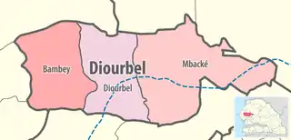
Diourbel Department
Diourbel Department is one of the 45 departments of Senegal, one of the three constituting the Diourbel Region.
Diourbel | |
|---|---|
 Location in the Diourbel Region | |
| Country | |
| Region | Diourbel Region |
| Capital | Diourbel |
| Area | |
| • Total | 1,175 km2 (454 sq mi) |
| Population (2013 census) | |
| • Total | 268,215 |
| • Density | 230/km2 (590/sq mi) |
| Time zone | UTC+0 (GMT) |
There is one commune in the department, which is Diourbel.
The rural districts (communautés rurales) are:
- Ndindy Arrondissement
- Ndankh Sene
- Gade Escale
- Keur Ngalgou
- N'Dindy
- Taïba Moutoupha
- Touba Lappe
- Ndoulo Arrondissement
- N'Doulo
- N'Gohe
- Patar
- Tocky-Gare
- Toure M'Bonde
- Historic sites [1]
- Grand Mosque of Diourbel
- Prefecture
- Railway station
- Building housing the Post Office
- Battlefield of Bounghoye
- Battlefield of Ndiaby
- Ibrahima Thioye school, Diourbel town
- Baobab tree called "Gouye Sambaye Karang" in Keur Yéli Manel Fall Quarter, Diourbel town
- Baobab tree called "Gouye Woté" in Ndiodione Quarter, Diourbel
- Residence of Cheikh Ahmadou Bamba, Diourbel town
- Battlefield of Sambé
- Battlefield of Ngagnane, administrative centre of Diourbel
- Sereer tombs at Ndayane and associated remains
This article is issued from Wikipedia. The text is licensed under Creative Commons - Attribution - Sharealike. Additional terms may apply for the media files.