Doheny Drive
Doheny Drive is a north–south thoroughfare mostly through Beverly Hills and West Hollywood, in Los Angeles County, California.
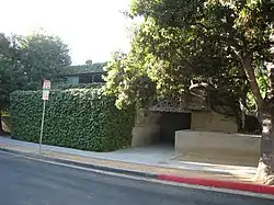
 Lloyd Wright Home and Studio on Doheny Drive | |
| Length | 4.2 mi (6.8 km)[1] |
|---|---|
| South end | Dead end south of Cashio Street in Los Angeles[2] |
| North end | Dead end north of Swallow Drive in Los Angeles[3] |
It is named for Edward L. Doheny, an early 20th century oil tycoon based in Los Angeles.
Route
Doheny Drive starts south of Cashio Street, in a residential cul-de-sac near the Beverlywood neighborhood of Los Angeles.[2] After crossing Pico Boulevard and the neighborhood of Pico-Robertson, it enters Beverly Hills at Whitworth Drive and crosses Olympic Boulevard. After crossing Wilshire Boulevard, Santa Monica Boulevard, Sunset Boulevard, and other east/west arteries, Doheny Drive ends north of Swallow Drive in the Hollywood Hills West neighborhood at another residential cul-de-sac. It forms the boundary of West Hollywood and Beverly Hills between Beverly Boulevard and Phyllis Street.[3]
Doheny Drive encounters few traffic lights, making it a relatively quick north–south trip. From Santa Monica Boulevard to Sunset Boulevard, condominiums and houses predominate. The road forms the western end of the Sunset Strip, with Laurel Canyon Boulevard−Crescent Heights Boulevard the eastern end.
References
- "1598-1500 S Doheny Dr, Los Angeles, CA 90035 to 1859-1803 N Doheny Dr, Los Angeles, CA 90069 - Google Maps". Retrieved 19 March 2022.
- "Google Maps". Google Maps.
- "34°06'23.0"N 118°23'16.3"W - Google Maps". Retrieved 19 March 2022.