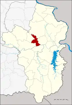
Don Mot Daeng district
Don Mot Daeng (Thai: ดอนมดแดง, pronounced [dɔ̄ːn mót dɛ̄ːŋ]) is a district (amphoe) in the central part of Ubon Ratchathani province, northeastern Thailand. The district is named after the island Don Mot Daeng in the Mun River.
Don Mot Daeng, Thailand
ดอนมดแดง | |
|---|---|
 District location in Ubon Ratchathani province | |
| Coordinates: 15°22′44″N 105°1′38″E | |
| Country | Thailand |
| Province | Ubon Ratchathani |
| Seat | Lao Daeng |
| Area | |
| • Total | 234.0 km2 (90.3 sq mi) |
| Population (2005) | |
| • Total | 26,301 |
| • Density | 112.4/km2 (291/sq mi) |
| Time zone | UTC+7 (ICT) |
| Postal code | 34000 |
| Geocode | 3424 |
History
The area of the district was split off from Mueang Ubon Ratchathani district and formed a minor district (king amphoe) on 1 April 1991.[1] It was upgraded to a full district on 5 December 1996.[2]
The name Don Mot Daeng meaning "upland of red ant".
Geography
Neighboring districts are (from the east clockwise) Tan Sum, Sawang Wirawong, Mueang Ubon Ratchathani, Lao Suea Kok and Trakan Phuet Phon of Ubon Ratchathani Province.
The important water resources are the Mun and Se Bok River.
Administration
The district is divided into four sub-districts (tambons), which are further subdivided into 46 villages (mubans). There are no municipal (thesaban) areas, and four tambon administrative organizations (TAO).
| No. | Name | Thai name | Villages | Pop. | |
|---|---|---|---|---|---|
| 1. | Don Mot Daeng | ดอนมดแดง | 13 | 8,664 | |
| 2. | Lao Daeng | เหล่าแดง | 13 | 6,924 | |
| 3. | Tha Mueang | ท่าเมือง | 10 | 5,996 | |
| 4. | Kham Hai Yai | คำไฮใหญ่ | 10 | 4,717 |
References
- ประกาศกระทรวงมหาดไทย เรื่อง แบ่งเขตท้องที่อำเภอเมืองอุบลราชธานี จังหวัดอุบลราชธานี ตั้งเป็นกิ่งอำเภอดอนมดแดง (PDF). Royal Gazette (in Thai). 108 (15 ก): 1064. January 31, 1991. Archived from the original (PDF) on March 9, 2012.
- พระราชกฤษฎีกาตั้งอำเภอเหนือคลอง อำเภอนายายอาม อำเภอท่าตะเกียบ อำเภอขุนตาล อำเภอแม่ฟ้าหลวง อำเภอแม่ลาว อำเภอรัษฎา อำเภอพุทธมณฑล อำเภอวังน้ำเขียว อำเภอเจาะไอร้อง อำเภอชำนิ อำเภอโนนดินแดง อำเภอปางมะผ้า อำเภอสนธิ อำเภอหนองม่วง อำเภอเบญจลักษ์ อำเภอโพนนาแก้ว อำเภอบุ่งคล้า อำเภอดอนมดแดง และอำเภอลืออำนาจ พ.ศ. ๒๕๓๙ (PDF). Royal Gazette (in Thai). 113 (62 ก): 5–8. November 20, 1996. Archived from the original (PDF) on May 21, 2009.