Driebruggen
Driebruggen is a village in the Dutch province of South Holland. It is a part of the former municipality of Reeuwijk, and lies about 6 km east of Gouda.
Driebruggen | |
|---|---|
Village | |
 Bridge over the Dubbele Wiericke in Driebruggen | |
 Driebruggen Location in the province of South Holland in the Netherlands  Driebruggen Location in the Netherlands | |
| Coordinates: 52°2′36″N 4°47′55″E | |
| Country | Netherlands |
| Province | South Holland |
| Municipality | Bodegraven-Reeuwijk |
| Area | |
| • Total | 6.38 km2 (2.46 sq mi) |
| Elevation | −1.7 m (−5.6 ft) |
| Population (2021)[1] | |
| • Total | 2,005 |
| • Density | 310/km2 (810/sq mi) |
| Time zone | UTC+1 (CET) |
| • Summer (DST) | UTC+2 (CEST) |
| Postal code | 3465[1] |
| Dialing code | 0348 |
According to the 1615 map of Rijnland, there were indeed three bridge in Driebruggen.[3] Driebruggen is a road village without a church which developed in the 17th century near the bridge over the Dubbele Wiericke.[4]
Driebruggen was a separate municipality between 1964 and 1989. The name from this village means 3 bridges. It was created in a merger of Hekendorp, Lange Ruige Weide, Papekop, and Waarder.[5]
Gallery
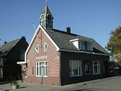 Former town hall
 Villa in Driebruggen
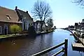 View on the canal
References
- "Kerncijfers wijken en buurten 2021". Central Bureau of Statistics. Retrieved 2 May 2022.
- "Postcodetool for 3465HA". Actueel Hoogtebestand Nederland (in Dutch). Het Waterschapshuis. 24 July 2019. Retrieved 2 May 2022.
- "Driebruggen". Plaatsengids (in Dutch). Retrieved 2 May 2022.
- Ronald Stenvert & Sabine Broekhoven (2004). "Driebruggen" (in Dutch). Zwolle: Waanders. ISBN 90-400-9034-3. Retrieved 2 May 2022.
- Ad van der Meer and Onno Boonstra, "Repertorium van Nederlandse gemeenten", KNAW, 2006. "KNAW > Publicaties > Detailpagina". Archived from the original on 2007-02-20. Retrieved 2009-12-03.
This article is issued from Wikipedia. The text is licensed under Creative Commons - Attribution - Sharealike. Additional terms may apply for the media files.