Duckett's Green
Duckett's Green is an area of north London, England in the United Kingdom and part of the London Borough of Haringey. It is an inner-suburban area located 5.8 miles (9.4 km) north of Charing Cross.

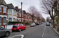
The area is mainly residential and borders Duckett's Common. Its area is roughly defined by West Green Road to the south-west, Belmont Road to the south-east, Ivatt Way and Langham Road to the north-east, Westbury Avenue to the north and Turnpike Lane Bus Station to the north-west.
History
The area takes its name from one of the manors of Tottenham, Dovecotes, or Duckett's.[1] The manor house itself was situated further north in the centre of what is today Wood Green. Settlement is first recorded at Duckett's Green in 1293.[2] With agriculture being the main activity in this small area, population remained sparse until the middle of the nineteenth century. By 1860 a few houses had been built along West Green Road just to the east of the junction with Green Lanes and stretching northward, facing Duckett's Common, as far as Duckett's farm-house, then called Dovecote House.[3] Development had also begun along Milton Road.[4]
Education
Transport and locale
Nearest places
Nearest tube station
Nearest railway stations
Links
- Duckett's Green shown on 'A New Topographical Map of the Country in the Vicinity of London, Describing all the New Improvements, Metropolitan Boroughs and Parish Boundaries c 1872' on the Mapco website
- Photo of the mid-nineteenth Century house in Duckett's Green along Green Lanes
- Duckett's Green on Google Maps
References
- 'Tottenham: Growth before 1850', A History of the County of Middlesex, Volume 5: 1976, pp. 313-17
- 'Tottenham: Growth before 1850', A History of the County of Middlesex, Volume 5: 1976, pp. 313-17
- 'Tottenham: Growth before 1850', A History of the County of Middlesex, Volume 5: 1976, pp. 313-17
- James Wyld's map of the Vicinity of London 1872.


