Dunajec
The Dunajec (Polish pronunciation: [duˈnajɛt͡s]; Goral dialects: Dónajec; Slovak pronunciation: [ˈdunajet͡s]) is a river running through northeastern Slovakia and southern Poland. It is also regarded as the main river of the Goral Lands. It is a right tributary of the Vistula River. It begins in Nowy Targ at the junction of two short mountain rivers, Czarny Dunajec and Biały Dunajec (Black and White Dunajec). Dunajec forms the border between Poland and Slovakia for 17 kilometres (11 mi)[1] in the Pieniny Środkowe (Slovak: Centrálne Pieniny) range, east of the Czorsztyn reservoir.
| Dunajec | |
|---|---|
 Dunajec viewed from Trzy Korony | |
| Location | |
| Country | Poland, Slovakia |
| Physical characteristics | |
| Mouth | |
• location | Vistula |
• coordinates | 50.2431°N 20.7283°E |
| Length | 249 km (155 mi) |
| Basin size | 6,796 km2 (2,624 sq mi) |
| Discharge | |
| • average | 85.5 m3/s (3,020 cu ft/s) |
| Basin features | |
| Progression | Vistula→ Baltic Sea |
Geography
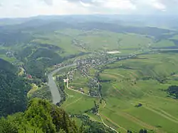
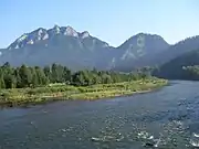
The Dunajec is 249 kilometres (155 mi) long, including its source river Czarny Dunajec,[1] which makes it Poland's thirteenth longest river. It has a basin area of 6,796 square kilometres (2,624 sq mi) (4,838 [1,868] in Poland, and 1,958 [756] in Slovakia).[1] On the Slovak/Polish border, it flows through the Zamagurie region, with attractions such as the Dunajec River Gorge, the Trzy Korony massif with a 500 metres (1,600 ft) precipice, Červený Kláštor, and two Pieniny castles in Czorsztyn and Niedzica.
Below the two source streams Dunajec flows through a broad valley called Nowotarska Basin. It then supplies the waters of the dam in Niedzica (Jezioro Czorsztyńskie Lake) and the dam in Sromowce Wyżne (Sromowce Wyżne reservoir). Flowing through the central part of the Pieniny range, it creates a picturesque turn at the Polish Slovak border between Sromowce Wyżne and Szczawnica, where it flows by Kotuńka rock which differentiates the area from the over parts of the river. Further down it turns to the north into the Western Beskid Mountains, and Sądecka Basin (where it merges with its own largest tributary, the Poprad river). It flows across an open valley of the Beskid Foothills and falls down across Rożnów Foothills (with two more dams: the Jezioro Rożnowskie Lake, and Jezioro Czchowskie Lake) and finally, it leads into the Sandomierz Basin and the valley of Vistula Lowlands. Dunajec flows into the Vistula River in the vicinity of Opatowiec.
Towns and townships
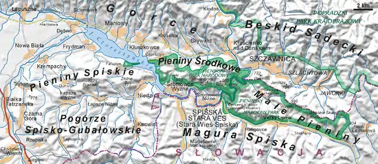
The Dunajec flows through or near these locations in Poland and north Slovakia:
|
Gallery
 Dunajec and the Trzy Korony Mountain
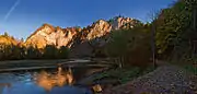 Dunajec in autumn
 Dunajec Gorge in the Pieniny mountains
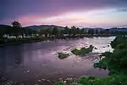 Dunajec in Sromowce Niżne
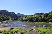 Dunajec in Szczawnica
See also
References
Tributaries of the Vistula River | ||
|---|---|---|
| Forming rivers |
|  |
| Main tributaries of the left bank | ||
| Main tributaries of the right bank |
| |
| Distributary |
| |
| Vistula | |
|---|---|
| Odra | |
| Vistula Lagoon | |
| Baltic Sea | |
Hydrography of Slovakia | ||||||||||||
|---|---|---|---|---|---|---|---|---|---|---|---|---|
| Rivers |
|  | ||||||||||
| Lakes |
| |||||||||||
| Reservoirs |
| |||||||||||
| River islands | ||||||||||||