Dunsandel
Dunsandel is a small rural town in the Canterbury region of the South Island, New Zealand. The town is located on the Canterbury Plains just south of the Selwyn River / Waikirikiri and about 40 km south of Christchurch. Dunsandel is a junction town on SH1, halfway between Christchurch and Ashburton, with roads leading to Leeston, Southbridge and Hororata. The town provides an important refreshment stop for main road travellers with eateries and coffee shops, as well as acting as a support town for the rural hinterland.
Dunsandel | |
|---|---|
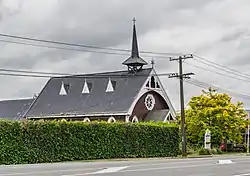 Dunsandel Methodist Church | |
| Coordinates: 43°39′38″S 172°11′34″E | |
| Country | New Zealand |
| Region | Canterbury region |
| District | Selwyn District |
| Ward | Ellesmere |
| Electorates |
|
| Government | |
| • Territorial authority | Selwyn District Council |
| • Regional council | Environment Canterbury |
| • Mayor of Selwyn | Sam Broughton |
| • Selwyn MP | Nicola Grigg |
| • Te Tai Tonga MP | Tākuta Ferris |
| Area | |
| • Total | 1.94 km2 (0.75 sq mi) |
| Population (June 2023)[2] | |
| • Total | 480 |
| • Density | 250/km2 (640/sq mi) |
The town was established to serve the local farming community which includes dairy, sheep and cropping and continues providing veterinary, transport and vehicle repair services. It was named after Dunsandle Castle, the home of Robert Daly, who had owned the land on which the town as established.[3] It has one primary school for approximately 150 children. The town is the home to the Dunsandel Cricket Club. The club's 'A' team has a reputation as one of the premier teams in the Ellesmere district.
Demographics
Dunsandel is described by Statistics New Zealand as a rural settlement, and covers 1.94 km2 (0.75 sq mi).[1] It had an estimated population of 480 as of June 2023,[2] with a population density of 247 people per km2. It is part of the Bankside statistical area.
| Year | Pop. | ±% p.a. |
|---|---|---|
| 2006 | 399 | — |
| 2013 | 441 | +1.44% |
| 2018 | 438 | −0.14% |
| Source: [4] | ||
.jpg.webp)
Dunsandel had a population of 438 at the 2018 New Zealand census, a decrease of 3 people (−0.7%) since the 2013 census, and an increase of 39 people (9.8%) since the 2006 census. There were 156 households, comprising 210 males and 228 females, giving a sex ratio of 0.92 males per female, with 105 people (24.0%) aged under 15 years, 63 (14.4%) aged 15 to 29, 213 (48.6%) aged 30 to 64, and 57 (13.0%) aged 65 or older.
Ethnicities were 93.8% European/Pākehā, 9.6% Māori, 0.7% Pasifika, and 1.4% Asian. People may identify with more than one ethnicity.
Although some people chose not to answer the census's question about religious affiliation, 65.1% had no religion, 23.3% were Christian, 0.7% had Māori religious beliefs and 2.1% had other religions.
Of those at least 15 years old, 33 (9.9%) people had a bachelor's or higher degree, and 63 (18.9%) people had no formal qualifications. 72 people (21.6%) earned over $70,000 compared to 17.2% nationally. The employment status of those at least 15 was that 207 (62.2%) people were employed full-time, 45 (13.5%) were part-time, and 9 (2.7%) were unemployed.[4]
Bankside
The Bankside statistical area covers 359.56 km2 (138.83 sq mi).[1] It had an estimated population of 1,900 as of June 2023,[5] with a population density of 5.3 people per km2.
| Year | Pop. | ±% p.a. |
|---|---|---|
| 2006 | 1,365 | — |
| 2013 | 1,605 | +2.34% |
| 2018 | 1,656 | +0.63% |
| Source: [6] | ||
Bankside had a population of 1,656 at the 2018 New Zealand census, an increase of 51 people (3.2%) since the 2013 census, and an increase of 291 people (21.3%) since the 2006 census. There were 627 households, comprising 873 males and 783 females, giving a sex ratio of 1.11 males per female. The median age was 32.9 years (compared with 37.4 years nationally), with 375 people (22.6%) aged under 15 years, 342 (20.7%) aged 15 to 29, 798 (48.2%) aged 30 to 64, and 144 (8.7%) aged 65 or older.
Ethnicities were 82.4% European/Pākehā, 6.3% Māori, 1.3% Pasifika, 11.8% Asian, and 3.8% other ethnicities. People may identify with more than one ethnicity.
The percentage of people born overseas was 24.8, compared with 27.1% nationally.
Although some people chose not to answer the census's question about religious affiliation, 53.6% had no religion, 33.0% were Christian, 0.4% had Māori religious beliefs, 0.9% were Hindu, 0.9% were Buddhist and 3.3% had other religions.
Of those at least 15 years old, 216 (16.9%) people had a bachelor's or higher degree, and 216 (16.9%) people had no formal qualifications. The median income was $45,100, compared with $31,800 nationally. 255 people (19.9%) earned over $70,000 compared to 17.2% nationally. The employment status of those at least 15 was that 822 (64.2%) people were employed full-time, 180 (14.1%) were part-time, and 27 (2.1%) were unemployed.[6]
Education
Dunsandel School is a contributing primary school catering for years 1 to 6.[7] It had a roll of 96 as of April 2023.[8] The school opened in 1879.[9] Selwyn and Upper Selwyn schools merged into Dunsandel School in 1936.[10]
References
- "ArcGIS Web Application". statsnz.maps.arcgis.com. Retrieved 18 October 2021.
- "Subnational population estimates (RC, SA2), by age and sex, at 30 June 1996-2023 (2023 boundaries)". Statistics New Zealand. Retrieved 25 October 2023. (regional councils); "Subnational population estimates (TA, SA2), by age and sex, at 30 June 1996-2023 (2023 boundaries)". Statistics New Zealand. Retrieved 25 October 2023. (territorial authorities); "Subnational population estimates (urban rural), by age and sex, at 30 June 1996-2023 (2023 boundaries)". Statistics New Zealand. Retrieved 25 October 2023. (urban areas)
- https://paperspast.natlib.govt.nz/newspapers/LT18730114.2.13
- "Statistical area 1 dataset for 2018 Census". Statistics New Zealand. March 2020. 7026739 and 7026741.
- "Population estimate tables - NZ.Stat". Statistics New Zealand. Retrieved 25 October 2023.
- "Statistical area 1 dataset for 2018 Census". Statistics New Zealand. March 2020. Bankside (334200). 2018 Census place summary: Bankside
- Education Counts: Dunsandel School
- "New Zealand Schools Directory". New Zealand Ministry of Education. Retrieved 12 December 2022.
- "Wanted". Lyttelton Times. 19 September 1879.
- Davies, A.M.F. (1993). The Heart of the Village - What determined the spatial distribution of North Canterbury Rural schools 1850-1940? (PDF) (Thesis). p. 98.