East Alliance, Ohio
East Alliance is an unincorporated community and census-designated place (CDP) in Mahoning County, Ohio, United States.[2] It was first listed as a CDP prior to the 2020 census.
East Alliance, Ohio | |
|---|---|
 Location of East Alliance in Mahoning County and in the State of Ohio | |
| Coordinates: 40°54′48″N 81°4′42″W | |
| Country | United States |
| State | Ohio |
| County | Mahoning |
| Township | Smith |
| Area | |
| • Total | 0.83 sq mi (2.14 km2) |
| • Land | 0.79 sq mi (2.05 km2) |
| • Water | 0.03 sq mi (0.09 km2) |
| Elevation | 1,059 ft (323 m) |
| Population (2020) | |
| • Total | 268 |
| • Density | 337.96/sq mi (130.48/km2) |
| Time zone | UTC-5 (Eastern (EST)) |
| • Summer (DST) | UTC-4 (EDT) |
| ZIP Code | 44601 (Alliance) |
| Area code(s) | 234/330 |
| FIPS code | 38-23254 |
| GNIS feature ID | 2812832[2] |
The CDP is in the southwest corner of Mahoning County and the southwest corner of Smith Township. It is bordered to the west by the city of Alliance in Stark County and to the south by Knox Township in Columbiana County. U.S. Route 62, following the Columbiana County line, runs along the south edge of East Alliance; it leads west into Alliance and east 11 miles (18 km) to Salem.
References
- "ArcGIS REST Services Directory". United States Census Bureau. Retrieved September 20, 2022.
- "East Alliance Census Designated Place". Geographic Names Information System. United States Geological Survey, United States Department of the Interior.
- "Census of Population and Housing". Census.gov. Retrieved June 4, 2016.
Municipalities and communities of Mahoning County, Ohio, United States | ||
|---|---|---|
| Cities | 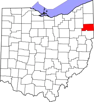 Map of Ohio highlighting Mahoning County | |
| Villages | ||
| Townships | ||
| CDPs | ||
| Other communities | ||
| Footnotes | ‡This populated place also has portions in an adjacent county or counties | |
This article is issued from Wikipedia. The text is licensed under Creative Commons - Attribution - Sharealike. Additional terms may apply for the media files.