East Suffolk District
East Suffolk is a local government district in Suffolk, England, which was established on 1 April 2019, following the merger of the existing Suffolk Coastal and Waveney districts.[2] At the 2011 census, the two districts had a combined population of 239,552.
East Suffolk
East Suffolk District | |
|---|---|
 Council logo | |
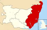 East Suffolk district within the county of Suffolk | |
| Coordinates: 52.2°N 1.5°E | |
| Sovereign state | United Kingdom |
| Constituent country | England |
| Region | East of England |
| Non-metropolitan county | Suffolk |
| Status | Non-metropolitan district |
| Admin HQ | East Suffolk House, Melton[1] |
| Incorporated | 1 April 2019 |
| Government | |
| • Type | Non-metropolitan district council |
| • Body | East Suffolk Council |
| Area | |
| • Total | 200 sq mi (510 km2) |
| Population (2011) | |
| • Total | 239,552 |
| • Density | 1,210/sq mi (469/km2) |
| Time zone | UTC0 (GMT) |
| • Summer (DST) | UTC+1 (BST) |
| Website | www |
The main towns and villages in the district include Aldeburgh, Beccles, Bungay, Felixstowe, Framlingham, Halesworth, Leiston, Lowestoft, Saxmundham and Southwold as well parts of the wider Ipswich built-up area including Kesgrave, Martlesham and Woodbridge.
The district covers a smaller area compared to the former administrative county of East Suffolk, which was abolished by the Local Government Act 1972.
Governance
As of the 2023 elections on 2 May, the composition of East Suffolk Council is as follows:
| Party | Seats | |
|---|---|---|
| Green | 16 | |
| Conservative | 15 | |
| Labour | 12 | |
| Liberal Democrats | 11 | |
| Independent | 1 | |
See also
- 2019 structural changes to local government in England
- West Suffolk, another district that was created in Suffolk on 1 April 2019.
References
- "Contact us » East Suffolk Council". www.eastsuffolk.gov.uk.
- Ministry of Housing, Communities and Local Government (24 May 2018). "The East Suffolk (Local Government Changes) Order 2018". legislation.gov.uk. Retrieved 12 August 2018.
External links
| Boroughs or districts | |
|---|---|
| Major settlements (cities in italics) | |
| Topics | |