El Negrito
El Negrito | |
|---|---|
 El Negrito Location in Honduras | |
| Coordinates: 15°19′N 87°42′W | |
| Country | |
| Department | Yoro |
| Villages | 29 |
| Area | |
| • Municipality | 565 km2 (218 sq mi) |
| Population (2023 projection)[1] | |
| • Municipality | 50,550 |
| • Density | 89/km2 (230/sq mi) |
| • Urban | 20,646 |
| Time zone | UTC−06:00 (Central America) |
| Climate | Aw |
El Negrito (Spanish pronunciation: [el neˈɣɾito]) is a town, with an urban population of 13,260 (2023),[2] and a municipality in the department of Yoro, Honduras.
Villages
El Negrito has a total of 29 villages:
- Aldea Paujiles Norte
- Battán
- Campo Perdeíz
- Cerro Prieto No.1
- Cerro Prieto No.2
- El Jocomico
- El Junco
- El Naranjo
- El Negrito
- El Pate
- El Robledal
- El Rodeo
- Estero Indio
- Finca Treinta and Cinco
- Finca Treinta and Seis
- Guangolola 1
- Guangolola 2
- Guaymón No.1
- La Laguna
- La Majada
- La Veinte and Nueve
- La Veinte and Ocho
- Las Delicias
- Nueva San Antonio
- Samar
- San Jerónimo
- San José del Negrito
- Toyos
- Villa del Carmen and Treinta and Siete
Demographics
At the time of the 2013 Honduras census, El Negrito municipality had a population of 45,363. Of these, 95.35% were Mestizo, 3.33% White, 1.03% Indigenous (0.50% Tolupan, 0.19% Lenca, 0.15% Chʼortiʼ, 0.11% Nahua), 0.24% Black or Afro-Honduran and 0.05% others.[3]
References
- Citypopulation.de Population of departments and municipalities in Honduras
- Citypopulation.de Population of cities in Honduras
- Instituto Nacional de Estadística (INE), bases de datos en línea
Capital: Yoro | ||
| Municipalities | 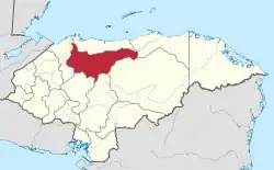 | |
This article is issued from Wikipedia. The text is licensed under Creative Commons - Attribution - Sharealike. Additional terms may apply for the media files.