El Salvador, Misamis Oriental
El Salvador, officially the City of El Salvador (Cebuano: Dakbayan sa El Salvador; Filipino: Lungsod ng El Salvador), is a 6th class component city in the province of Misamis Oriental, Philippines. According to the 2020 census, it has a population of 58,771 people.[3]
El Salvador | |
|---|---|
| City of El Salvador | |
 From left to right: Divine Mercy Shrine; Barangay Poblacion of El Salvador; Our Lady of the Snows Parish Church | |
 Flag  Seal | |
| Anthem: Tagnipan-ong Paraiso | |
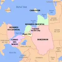
 Map of Misamis Oriental with El Salvador highlighted | |
OpenStreetMap | |
.svg.png.webp) El Salvador Location within the Philippines | |
| Coordinates: 8°34′N 124°31′E | |
| Country | Philippines |
| Region | Northern Mindanao |
| Province | Misamis Oriental |
| District | 2nd district |
| Founded | June 15, 1948 |
| Cityhood | June 27, 2007 (Lost cityhood in 2008 and 2010) |
| Affirmed Cityhood | February 15, 2011 |
| Barangays | 15 (see Barangays) |
| Government | |
| • Type | Sangguniang Panlungsod |
| • Mayor | Edgar S. Lignes |
| • Vice Mayor | Mark William U. Tan |
| • Representative | Yevgeny Vicente B. Emano |
| • City Council | Members |
| • Electorate | 44,389 voters (2022) |
| Area | |
| • Total | 106.15 km2 (40.98 sq mi) |
| Elevation | 79 m (259 ft) |
| Highest elevation | 998 m (3,274 ft) |
| Lowest elevation | 0 m (0 ft) |
| Population (2020 census)[3] | |
| • Total | 58,771 |
| • Density | 550/km2 (1,400/sq mi) |
| • Households | 15,121 |
| Demonym(s) | Salvadoreños, Salbadorenyos |
| Economy | |
| • Income class | 6th city income class |
| • Poverty incidence | 13.33 |
| • Revenue | ₱ 575.3 million (2020) |
| • Assets | ₱ 1,747 million (2020) |
| • Expenditure | ₱ 470.5 million (2020) |
| • Liabilities | ₱ 558.6 million (2020) |
| Service provider | |
| • Electricity | Misamis Oriental 1 Rural Electric Cooperative (MORESCO 1) |
| Time zone | UTC+8 (PST) |
| ZIP code | 9017 |
| PSGC | |
| IDD : area code | +63 (0)88 |
| Native languages | Cebuano Binukid Subanon Tagalog |
| Feast date | Sunday after Easter |
| Catholic diocese | Archdiocese of Cagayan de Oro |
| Patron saint | The Divine Mercy |
| Website | elsalvadorcity |
The city serves as a pilgrimage site for Divine Mercy devotees.
History
During Spanish colonial era, a soldier named Alejandro Acusar sailed with his family from Bohol to the area what is now El Salvador to seek a new life. From a distance while sailing, they sighted a place and decided to dock. They found a place to have abundant nipa huts, in which they named it Taganipa or Taguipa. Acusar and his small family had then established themselves through farming and fishing. A wave of migrants from Bohol later followed as well as settlers from Luzon, other parts of Visayas and neighboring areas surrounding Taganipa settled in the area following years later, establishing themselves as farmers and fisherfolks.
El Salvador was created from the barrios of El Salvador and Molugan with their sitios known as Sala, Sambulawan, Sinaloc, Lagtang, Talaba, Kalabaylabay and Hinigdaan, formerly part of Cagayan de Misamis, Misamis Oriental, in 1948.[5]
Etymology
The municipality's name means "the savior" in Spanish, pertaining that Taganipa provided crops of corn and vegetables to the neighboring places struck by famine at some point in the municipality's history. Soon these places were saved by famine through continuous agricultural support from Taganipa, resulting to be renamed as El Salvador to people's approval.
Cityhood
On June 27, 2007, the municipality of El Salvador becomes a city in the province of Misamis Oriental after ratification of Republic Act 9435.
The Supreme Court declared the cityhood law of El Salvador and 15 other cities unconstitutional after a petition filed by the League of Cities of the Philippines in its ruling on November 18, 2008. On December 22, 2009, the cityhood law of El Salvador and 15 other municipalities regain its status as cities again after the court reversed its ruling on November 18, 2008. On August 23, 2010, the court reinstated its ruling on November 18, 2008, causing El Salvador and 15 cities to become regular municipalities. Finally, on February 15, 2011, El Salvador becomes a city again including the 15 municipalities declaring that the conversion to cityhood met all legal requirements.
After six years of legal battle, in its board resolution, the League of Cities of the Philippines acknowledged and recognized the cityhood of El Salvador and 15 other cities.
Geography
El Salvador is located in the Province of Misamis Oriental in Northern Mindanao (Region X). It is bordered by the Municipality of Alubijid to the west, Opol to the east and Manticao and Naawan to the south. On the north, lies Macajalar Bay of the Bohol Sea.
Barangays
El Salvador is politically subdivided into 15 barangays. Each barangay consists of puroks while some have sitios.
One forms the center of the city (poblacion) whereas the other 14 are in the outlying areas. Some of them are even several kilometers away from the center of the city.
- Amoros
- Bolisong
- Cogon
- Himaya
- Hinigdaan
- Kalabaylabay
- Molugan
- Pedro S. Baculio (Bolo-Bolo)
- Poblacion
- Quibonbon
- Sambulawan
- San Francisco de Asis (Calongonan)
- Sinaloc
- Taytay
- Ulaliman
Climate
| Climate data for El Salvador City, Misamis Oriental | |||||||||||||
|---|---|---|---|---|---|---|---|---|---|---|---|---|---|
| Month | Jan | Feb | Mar | Apr | May | Jun | Jul | Aug | Sep | Oct | Nov | Dec | Year |
| Average high °C (°F) | 28 (82) |
29 (84) |
30 (86) |
31 (88) |
30 (86) |
30 (86) |
30 (86) |
30 (86) |
30 (86) |
30 (86) |
29 (84) |
29 (84) |
30 (85) |
| Average low °C (°F) | 24 (75) |
24 (75) |
24 (75) |
25 (77) |
26 (79) |
26 (79) |
25 (77) |
25 (77) |
25 (77) |
25 (77) |
25 (77) |
25 (77) |
25 (77) |
| Average precipitation mm (inches) | 271 (10.7) |
217 (8.5) |
193 (7.6) |
178 (7.0) |
344 (13.5) |
423 (16.7) |
362 (14.3) |
358 (14.1) |
329 (13.0) |
320 (12.6) |
322 (12.7) |
260 (10.2) |
3,577 (140.9) |
| Average rainy days | 23.2 | 19.5 | 22.0 | 22.8 | 29.6 | 28.9 | 30.3 | 29.8 | 28.1 | 28.8 | 26.1 | 24.1 | 313.2 |
| Source: Meteoblue[6] | |||||||||||||
Demographics
| Year | Pop. | ±% p.a. |
|---|---|---|
| 1903 | 4,315 | — |
| 1948 | 16,899 | +3.08% |
| 1960 | 10,521 | −3.87% |
| 1970 | 14,529 | +3.28% |
| 1975 | 16,915 | +3.10% |
| 1980 | 20,446 | +3.86% |
| 1990 | 26,721 | +2.71% |
| 1995 | 31,500 | +3.13% |
| 2000 | 34,650 | +2.06% |
| 2007 | 41,905 | +2.66% |
| 2010 | 44,848 | +2.50% |
| 2015 | 50,204 | +2.17% |
| 2020 | 58,771 | +3.15% |
| Source: Philippine Statistics Authority[7][8][9][10] | ||
Economy
El Salvador hosts several companies, plants and factories west of Misamis Oriental. These are Asia Brewery, Tanduay Rhum, Virgin Cola Bottling Plant (Visayas and Mindanao region distributor), Highland Fresh Daily Products, Monark Equipment, Zest-O, WL Foods Corporation and Universal Robina Corporation.
With regards to financial institutions, Rural Bank of El Salvador and lending institutions such as FICCO, Oro Coop, M Lhuillier and others are accessible at office hours in this place.
Attractions
- Divine Mercy Shrine (Misamis Oriental), located in the Divine Mercy Hills, PSB-Ulaliman which is overlooking Macajalar Bay. The shrine has a 50-foot statue of the Divine Mercy Christ, the biggest in Asia. It serves as a pilgrimage site for the Divine Mercy devotees. As a pilgrimage and sacred site, visitors are not allowed to wear shorts and other revealing clothing. Those who do so will be forced to cover themselves with a blue cloth provided by the shrine administrators.
- Burias Island, located just a few kilometers off the coast of Molugan or about 3 km west of the town of Opol.
- El Salvador Night Café and Market, is set up on Friday night at Barangay Poblacion. Tagnipa-ons and visitors gather to have barbecue, enjoy the live band music, beer, and also the great bargains from the nearby Night Market
- Our Lady of Snows Parish Church, newly constructed church located within the city.
- Abaga & Sikiop Falls, Located in barangay San Francisco de Asis.
- Tag-ilas Falls, Located in barangay Hinigdaan.
- Tuburan Spring, Located in barangay Poblacion .
- House of Pasalubong, Located in Zone 2, Barangay Poblacion
Culture
Feast day:
- August 5 (Our Lady of Snows)
- August 16 (Saint Roch (aka San Roque))
Charter day:
- June 27
Infrastructure
Transportation
El Salvador city can be reached via plane through Laguindingan Airport, then about less than 10 minutes bus ride east. Like any other place the national highway snakes through it. Visitors and locals can go around the city by just hailing a "sikad-sikad" or motorboat, "jeepneys" or motorcycles to the outlying barangays.
Communication
PLDT and MISORTEL are among the major phone lines, also transmitters or "cell sites" for all major "telecom" providers like Globe, Smart and Dito are serviceable in this city. Internet access is also available. Internet cafes can be found in various places in within the city. Broadband service is also available.
References
- City of El Salvador | (DILG)
- "2015 Census of Population, Report No. 3 – Population, Land Area, and Population Density" (PDF). Philippine Statistics Authority. Quezon City, Philippines. August 2016. ISSN 0117-1453. Archived (PDF) from the original on May 25, 2021. Retrieved July 16, 2021.
- Census of Population (2020). "Region X (Northern Mindanao)". Total Population by Province, City, Municipality and Barangay. Philippine Statistics Authority. Retrieved July 8, 2021.
- "PSA Releases the 2018 Municipal and City Level Poverty Estimates". Philippine Statistics Authority. December 15, 2021. Retrieved January 22, 2022.
- "An act creating the municipality of El Salvador, province of Misamis Oriental". LawPH.com. Archived from the original on July 10, 2012. Retrieved April 8, 2011.
- "El Salvador: Average Temperatures and Rainfall". Meteoblue. Retrieved April 29, 2020.
- Census of Population (2015). "Region X (Northern Mindanao)". Total Population by Province, City, Municipality and Barangay. Philippine Statistics Authority. Retrieved June 20, 2016.
- Census of Population and Housing (2010). "Region X (Northern Mindanao)" (PDF). Total Population by Province, City, Municipality and Barangay. National Statistics Office. Retrieved June 29, 2016.
- Censuses of Population (1903–2007). "Region X (Northern Mindanao)". Table 1. Population Enumerated in Various Censuses by Province/Highly Urbanized City: 1903 to 2007. National Statistics Office.
- "Province of Misamis Oriental". Municipality Population Data. Local Water Utilities Administration Research Division. Retrieved December 17, 2016.
- "Poverty incidence (PI):". Philippine Statistics Authority. Retrieved December 28, 2020.
- "Estimation of Local Poverty in the Philippines" (PDF). Philippine Statistics Authority. November 29, 2005.
- "2003 City and Municipal Level Poverty Estimates" (PDF). Philippine Statistics Authority. March 23, 2009.
- "City and Municipal Level Poverty Estimates; 2006 and 2009" (PDF). Philippine Statistics Authority. August 3, 2012.
- "2012 Municipal and City Level Poverty Estimates" (PDF). Philippine Statistics Authority. May 31, 2016.
- "Municipal and City Level Small Area Poverty Estimates; 2009, 2012 and 2015". Philippine Statistics Authority. July 10, 2019.
- "PSA Releases the 2018 Municipal and City Level Poverty Estimates". Philippine Statistics Authority. December 15, 2021. Retrieved January 22, 2022.
External links
- Official website of the City Government of El Salvador
- Philippine Standard Geographic Code
- Philippine Census Information
- Local Governance Performance Management System
Places adjacent to El Salvador, Misamis Oriental | ||||||||||||||||
|---|---|---|---|---|---|---|---|---|---|---|---|---|---|---|---|---|
| ||||||||||||||||