Conecuh River
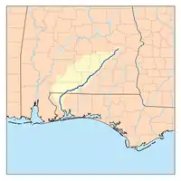
The Conecuh River (upper portion) and Escambia River (lower portion) are a single 258-mile-long (415 km) river in the southern United States, which flows from Alabama through Florida into the Gulf of Mexico.
| Conecuh River | |
|---|---|
 | |
| Location | |
| Country | United States |
| Location | Pensacola, Florida, Brewton, Alabama, East Brewton, Alabama, Pollard, Alabama, Flomaton, Alabama, Riverview, Alabama |
| Physical characteristics | |
| Source | |
| • coordinates | 32.1371°N 85.6786°W |
| Mouth | |
• location | Gulf of Mexico |
• coordinates | 30.9966°N 87.1758°W |
| Length | 258 miles (415 km)[1] |
The Conecuh River rises near Union Springs, Alabama and flows 198 miles (319 km)[1] in a general southwesterly direction into Florida near the town of Century. The river's name changes from the Conecuh to the Escambia at the junction of Escambia Creek, 1.2 miles (1.9 km) downstream from the Florida-Alabama line. After this point, the Escambia River flows 60 miles (97 km)[1] south to Escambia Bay, an arm of Pensacola Bay.
.jpg.webp)
Train unloading logs into Escambia River in the 1890s
The river is dredged in the lower course.
References
- U.S. Geological Survey. National Hydrography Dataset high-resolution flowline data. The National Map Archived 2012-03-29 at the Wayback Machine, accessed April 15, 2011
This article is issued from Wikipedia. The text is licensed under Creative Commons - Attribution - Sharealike. Additional terms may apply for the media files.