Estero, Florida
Estero (which is the Spanish word for estuary) is an incorporated village in Lee County, Florida, United States, located directly beside the first aquatic nature preserve established in Florida: The Estero Bay Aquatic Preserve, otherwise referred to as Estero Bay Preserve State Park which is within Estero Bay, Florida. As of the 2020 census, the population was 36,939.[6] During the 2010 census, Estero was an unincorporated community, or census-designated place, the population at that time was 22,612.[7] Estero incorporated as a village in 2014.[2] In 2019, the village's estimated population was 33,871.[8] Estero is part of the Cape Coral-Fort Myers, Florida Metropolitan Statistical Area.
Village of Estero, Florida | |
|---|---|
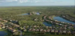 A neighborhood of Estero | |
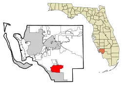 Location in Lee County, Florida | |
| Coordinates: 26°25′40″N 81°47′42″W[1] | |
| Country | United States |
| State | Florida |
| County | Lee |
| Incorporated (village) | December 31, 2014[2] |
| Government | |
| • Type | Mayor–council |
| • Mayor | Jon McLain |
| Area | |
| • Total | 25.39 sq mi (65.76 km2) |
| • Land | 24.37 sq mi (63.12 km2) |
| • Water | 1.02 sq mi (2.64 km2) |
| Elevation | 13 ft (4 m) |
| Population (2020) | |
| • Total | 36,939 |
| • Density | 1,515.82/sq mi (585.25/km2) |
| Time zone | UTC-5 (Eastern (EST)) |
| • Summer (DST) | UTC-4 (EDT) |
| ZIP code | 33928 & 33967 |
| Area code | 239 |
| FIPS code | 12-21150[5] |
| GNIS feature ID | 2771501[1] |
| Website | estero-fl |
Sandwiched along Florida’s Gulf Coast between Naples to the south and Fort Myers to the north, Estero is known as a popular destination for both high-end shopping and for exploring history and wildlife at its two state parks: Mound Key Archaeological State Park, which is only attainable by boat, canoe, or kayak and the Koreshan State Historic Site.
Estero is the home of Hertz Arena, which hosts the home games for the Florida Everblades ECHL ice hockey team. Florida Gulf Coast University is located just north of the Estero village limits.[9]
History
Mound Key, located in Estero Bay, is believed to have been the ceremonial center of the Calusa Indians when they were encountered by the Spanish in the early 1500s.[10] German homesteader Gustave Damkohler began planting mulberry trees in 1882 along the Estero River, followed by others who established fish camps and the region's first citrus groves.[11] In 1894, Damkohler donated property to the followers of Cyrus Teed, who proposed a theory that people live on the inside of the Earth's outer skin, and that celestial bodies are all contained inside the hollow Earth. This theory, which he called Koreshan Unity, drew followers to occupy and develop Damkohler's original 320-acre (1.3 km2) tract. They were business-oriented and lived communally, prospering enough to found their own political party ("The Progressive Liberty Party") and incorporate the town on September 1, 1904, as Estero.[12] At the behest of other local officials, the Florida legislature abolished the municipality of Estero in 1907.[13]
The 1908 death of Teed (who claimed to be immortal) was a critical blow to the group's faith, whose membership dwindled into the 1960s. The foundation remains as "The College of Life Foundation", which contributed (for example) at least $25,000 to the Gulf Shore Playhouse in or around 2007.[14] The Koreshans' original tract is now owned by Florida as the Koreshan State Historic Site.
Access to Estero was greatly improved in the 1920s when the Tamiami Trail, a highway linking Tampa and Miami, and two railroads were built through the area. The Tamiami Trail was fully complete in 1928. The Atlantic Coast Line Railroad (via its Fort Myers Southern Railroad subsidiary) began service through Estero in 1925. A competing railroad, the Seaboard Air Line Railroad (via its Seaboard-All Florida Railway subsidiary) also began service through Estero in 1927. Today, the former Atlantic Coast Line tracks are still in place east of US 41 and have been owned by Seminole Gulf Railway since 1987.[15] The former Seaboard tracks were removed in the 1940s and its former route west of US 41 is now an FPL power line corridor.
Estero incorporated as a village on December 31, 2014.[2]
Geography
The Village of Estero is located in southern Lee County at 26°25′56″N 81°48′34″W (26.432237, –81.809447).[16] It is bordered to the south by the city of Bonita Springs and to the north by unincorporated San Carlos Park and Three Oaks.
According to the United States Census Bureau, the village of Estero has a total area of 25.4 square miles (65.7 km2), of which 24.4 square miles (63.1 km2) are land and 1.0 square mile (2.7 km2), or 4.05%, are water.[17]
Historically and culturally, the heart of Estero is the spring-fed Estero River, which flows to Estero Bay. Some of the earliest settlers of the area (notably the Alvarez, Fernandez, Johnson, and Soto families) were fishing families that lived on Mound Key, a mangrove-ringed island that dominates Estero Bay. During the early 20th century, these families moved upriver to the settlement which came to be known as Estero. Estero is also the location of a utopian community called the Koreshan Unity, which is now preserved as the Koreshan State Historic Site. Until the 1970s, most settlement and development in Estero was near the river.
Demographics
| Census | Pop. | Note | %± |
|---|---|---|---|
| 1940 | 182 | — | |
| 2000 | 9,503 | — | |
| 2010 | 22,612 | 137.9% | |
| 2020 | 36,939 | 63.4% | |
| U.S. Decennial Census[18] | |||
In the past, during the census[5] of 2000, there were 9,503 people, 4,608 households, and 3,336 families residing in the CDP. The population density was 450.7 inhabitants per square mile (174.0/km2). There were 7,345 housing units at an average density of 348.4 per square mile (134.5/km2). The racial makeup of the CDP was 97.43% White, 0.64% African American, 0.11% Native American, 0.35% Asian, 0.01% Pacific Islander, 0.77% from other races, and 0.69% from two or more races. Hispanic or Latino of any race were 3.19% of the population.
There were 4,608 households, out of which 10.0% had children under the age of 18 living with them, 68.2% were married couples living together, 2.8% had a female householder with no husband present, and 27.6% were non-families. 23.4% of all households were made up of individuals, and 12.4% had someone living alone who was 65 years of age or older. The average household size was 2.01 and the average family size was 2.31.
In the CDP, the population was spread out, with 9.2% under the age of 18, 4.9% from 18 to 24, 14.1% from 25 to 44, 31.1% from 45 to 64, and 40.6% who were 65 years of age or older. The median age was 61 years. For every 100 females, there were 93.1 males. For every 100 females age 18 and over, there were 92.6 males.
As of the census 2019 American Community Survey 5-Year Estimates, the median income for a household in the village of Estero, Florida was $82,054, the median income for a family was $98,989, and the median income for Married-couple families was $101,086.[19]
The significant and sustained increase in median income in Estero can be attributed to a long-term influx of affluent households through inbound migration. In the past, the median income for a household in the CDP was $43,734, and the median income for a family was $51,227. In the past, Males had a median income of $38,886 versus $27,883 for females. In the past, the per capita income for the CDP was $30,521. In the past, about 1.9% of families and 3.2% of the population were below the poverty line, including 1.1% of those under age 18 and 3.2% of those age 65 or over.
Economy
On May 7, 2013, the Hertz Corporation announced it was moving its corporate headquarters and about 750 jobs to Estero from its former bases at Park Ridge, New Jersey and Tulsa, Oklahoma. Hertz built a $75 million building at the southeast corner of US-41 and Williams Road on a previously vacant lot and cleared parcel that already contained a retention pond.[20] The land is immediately south of Corkscrew Village and about a mile north of Coconut Point Mall.
Arts and culture
Estero is home to the Art Council of Southwest Florida which runs the nonprofit cooperative COCO Art Gallery at Coconut Point Mall in Estero, Florida. In 2023 the Artistic & Operations Center for the Southwest Florida Symphony relocated to Coconut Point Mall in Estero, Florida. Estero is known for being an upscale shopping and entertainment destination and in addition to the expansive Coconut Point shopping center is also home to Miromar Outlets, with over 140 stores and the 400,000-square-foot Miromar Design Center. Additionally, Gulf Coast Town Center is located just 3 miles from the northern border of Estero.
References
- "Village of Estero". Geographic Names Information System. United States Geological Survey, United States Department of the Interior. May 7, 2015.
- "Estero History". Village of Estero. Retrieved March 7, 2022.
- "Council". Village of Estero. Retrieved April 18, 2021.
- "2020 U.S. Gazetteer Files". United States Census Bureau. Retrieved October 31, 2021.
- "U.S. Census website". United States Census Bureau. Retrieved January 31, 2008.
- "Profile of General Population and Housing Characteristics: 2020 Census Summary File 1 (DP-1), Estero CDP, Florida". U.S. Census Bureau. Retrieved November 20, 2019.
- "Profile of General Population and Housing Characteristics: 2010 Census Summary File 1 (DP-1), Estero CDP, Florida". American FactFinder. U.S. Census Bureau. Archived from the original on February 13, 2020. Retrieved November 20, 2019.
- "Quick Facts: Estero village, Florida". U.S. Census Bureau. July 1, 2019. Retrieved April 18, 2021.
- Map of Estero Planning District
- "Mound Key Archaeological State Park". Florida Department of Environmental Protection. Retrieved April 18, 2021.
- Quentin Quesnell. (2020). "Early Estero," pp. 13-20. Published by the Estero Historical Society. ISBN 0-9726287-0-3.
- Tampa Tribune. September 4, 1904, p. 1. "Biggest City in the World: New Jerusalem covers seventy-five square miles."
- Pensacola News Journal. May 16, 1907, p. 4. "Will investigate the I.I. Committee."
- "Donors' page for the Gulf Shore Playhouse, showing College of Life Foundation donation as of 21 April 2008". Archived from the original on May 10, 2008. Retrieved April 21, 2008.
- Turner, Gregg M. (December 1, 1999). Railroads of Southwest Florida. Images of America. Arcadia Publishing.
- "US Gazetteer files: 2010, 2000, and 1990". United States Census Bureau. February 12, 2011. Retrieved April 23, 2011.
- "U.S. Gazetteer Files: 2019: Places: Florida". U.S. Census Bureau Geography Division. Retrieved November 20, 2019.
- "Census of Population and Housing". Census.gov. Retrieved June 4, 2016.
- "Explore Census Data". Data.census.gov. Retrieved March 21, 2022.
- Corporate Governance Overview, The Hertz Corporation. Accessed December 27, 2011.
