Falun, Kansas
Falun is an unincorporated community in southwestern Saline County, Kansas, United States.[1] As of the 2020 census, the population of the community and nearby areas was 83.[2] It lies southwest of Salina and northwest of Lindsborg at the intersection of Forsse Road and Hedberg Road, about 7.5 miles west of Interstate 135 highway, or about 8 miles west of Assaria.[3] It lies next to an abandoned railroad.
Falun, Kansas | |
|---|---|
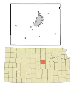 Location within Saline County and Kansas | |
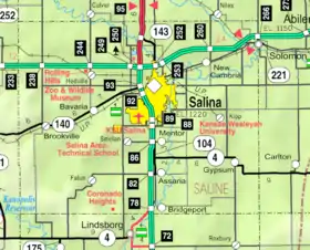 KDOT map of Saline County (legend) | |
| Coordinates: 38°40′16″N 97°45′34″W[1] | |
| Country | United States |
| State | Kansas |
| County | Saline |
| Founded | 1870 |
| Elevation | 1,348 ft (411 m) |
| Population | |
| • Total | 83 |
| Time zone | UTC-6 (CST) |
| • Summer (DST) | UTC-5 (CDT) |
| ZIP code | 67442 |
| Area code | 785 |
| FIPS code | 20-22900 [1] |
| GNIS ID | 476938 [1] |
History
The first post office in Falun was established in 1870.[4]
It has a post office with the ZIP code 67442.[5]
Geography
Its elevation is 1,348 feet (411 m), and it is located at 38°40′16″N 97°45′34″W (38.6711171, -97.7594855).[6]
Demographics
| Census | Pop. | Note | %± |
|---|---|---|---|
| 2020 | 83 | — | |
| U.S. Decennial Census | |||
For statistical purposes, the United States Census Bureau has defined Falun as a census-designated place (CDP). Also, this community is a part of the Salina micropolitan area.

Education
The community is served by Smoky Valley USD 400 public school district.
Notable people
- U. Alexis Johnson (1908-1997), United States diplomat was born in Falun.
References
- "Falun, Kansas", Geographic Names Information System, United States Geological Survey, United States Department of the Interior
- "Profile of Falun, Kansas (CDP) in 2020". United States Census Bureau. Archived from the original on November 13, 2021. Retrieved November 13, 2021.
- Rand McNally. The Road Atlas '08. Chicago: Rand McNally, 2008, p. 41.
- "Kansas Post Offices, 1828-1961". Kansas Historical Society. Archived from the original on October 9, 2013. Retrieved June 23, 2014.
- USPS – Cities by ZIP Code
- Geographic Names Information System Feature Detail Report, Geographic Names Information System, 1978-10-13. Accessed 2008-04-12.
Further reading
External links
Municipalities and communities of Saline County, Kansas, United States | ||
|---|---|---|
| Cities | 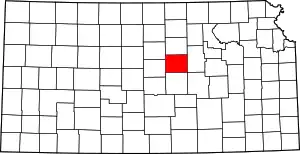 Map of Kansas highlighting Saline County | |
| Unincorporated communities | ||
| Townships |
| |
| Footnotes | †This community is designated a Census-Designated Place (CDP) by the United States Census Bureau. ‡This community also has portions in an adjacent county or counties. | |