Favona
Favona is a mostly industry-dominated suburb of Auckland, New Zealand, and is part of the Māngere area. The suburb is in the Manukau ward, one of the thirteen administrative divisions of Auckland city, and is under governance of the Auckland Council.
Favona | |
|---|---|
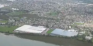 Favona from the air, looking south. | |
| Coordinates: 36°57′9″S 174°48′1″E | |
| Country | New Zealand |
| City | Auckland |
| Local authority | Auckland Council |
| Electoral ward | Manukau ward |
| Local board | Māngere-Ōtāhuhu Local Board |
| Area | |
| • Land | 261 ha (645 acres) |
| Population (June 2022)[2] | |
| • Total | 10,800 |
| Māngere Bridge | (Māngere Inlet) | (Māngere Inlet) |
| Māngere Bridge |
|
Ōtāhuhu |
| Māngere | Māngere | Māngere East |
Etymology
The origin of the name Favona is unknown, although it may relate to the cattle of the Robertson family who farmed in Māngere.[3] Favona was the name of a race horse who came to prominence in the 1890s, who raised on John Lennard's farm in Māngere.[4][5][6] In 1899 Hugh Mosman, member of the Queensland Legislative Council, purchased 300 acres of farmland in the area, calling his estate the Favona Farm.[3][7][8]
Geography
Favona is located south of the Māngere Inlet, around the Tararata Creek and Harania Creek.[9] The Boggust Park Crater in Favona is the oldest known feature of the Auckland volcanic field, erupting an estimated 130,000 years ago.[10]
History
The first evidence of Tāmaki Māori in the coastal Māngere area comes from the 14th century, with evidence of the first settlements later in the 15th century.[11] Area is close to Te Tō Waka, the shortest portage connecting the Manukau Harbour to the Waitematā Harbour at Ōtāhuhu.[12]
In January 1836 missionary William Thomas Fairburn brokered a land sale between Tāmaki Māori chiefs, Pōtatau Te Wherowhero and Turia of Ngāti Te Rau, covering the majority of modern-day South Auckland between Ōtāhuhu and Papakura. The sale was envisioned as a way to end hostilities in the area, but it is unclear what the chiefs understood or consented to. Māori continued to live in South Auckland, unchanged by this sale.[13] Fairburn was criticised for the sheer size of the purchase, and in 1842 the Crown significantly reduced the size of his land holdings,[14] and the Crown partitioned much of the land for European settlers.[13] Until the 1860s, the Māori population of the Manukau Harbour and Waikato areas produced goods to sell or barter at the port of Onehunga.[15]: 3 On 9 July 1863, due to fears of the Māori King Movement, Governor Grey proclaimed that all Māori living in the South Auckland area needed to swear loyalty to the Queen and give up their weapons. Most people refused due to strong links to Tainui, leaving for the south before the Government's Invasion of the Waikato.[16]: 68 [15]: 4
In 1862, the first local government was established in the area, with the formation of the Mangerei Highway Board.[17] Favona remained a rural area until the mid-20th Century.[3] In the 1899, Hugh Mosman, member of the Queensland Legislative Council, purchased a 300-acre farm, which he used to breed race horses.[8][3] The farm was purchased by investors in 1910 and subdivided into urban farmlets, under the name Favona Park.[18] Some areas of Favona also historically had large areas of greenhouses, such as for tomato production.[19]
In mid-1922, the first store opened for the Favona community, which was followed by an Anglican hall, used for both church services and as a community hall.[3] After World War II, large-scale industrial developments began operating in Favona, including the Pacific Steel steel mill, which opened in the 1960s.[3][17]
The area is one is of relative poverty and until 2005 had one of New Zealand's largest caravan parks. It hosts the Mangere campus of Te Wānanga o Aotearoa. Numerous shipping and freight forwarding companies have premises in the industrial areas,[20] including the national distribution headquarters of supermarket chain Progressive Enterprises.
Demographics
Favona covers 2.61 km2 (1.01 sq mi)[1] and had an estimated population of 10,800 as of June 2022,[2] with a population density of 4,138 people per km2.
| Year | Pop. | ±% p.a. |
|---|---|---|
| 2006 | 7,488 | — |
| 2013 | 8,514 | +1.85% |
| 2018 | 9,684 | +2.61% |
| Source: [21] | ||
Favona had a population of 9,684 at the 2018 New Zealand census, an increase of 1,170 people (13.7%) since the 2013 census, and an increase of 2,196 people (29.3%) since the 2006 census. There were 1,959 households, comprising 4,866 males and 4,824 females, giving a sex ratio of 1.01 males per female, with 2,592 people (26.8%) aged under 15 years, 2,517 (26.0%) aged 15 to 29, 3,840 (39.7%) aged 30 to 64, and 735 (7.6%) aged 65 or older.
Ethnicities were 12.2% European/Pākehā, 14.2% Māori, 64.8% Pacific peoples, 21.3% Asian, and 1.3% other ethnicities. People may identify with more than one ethnicity.
The percentage of people born overseas was 43.5, compared with 27.1% nationally.
Although some people chose not to answer the census's question about religious affiliation, 15.1% had no religion, 64.6% were Christian, 1.1% had Māori religious beliefs, 7.4% were Hindu, 4.3% were Muslim, 1.1% were Buddhist and 1.1% had other religions.
Of those at least 15 years old, 873 (12.3%) people had a bachelor's or higher degree, and 1,572 (22.2%) people had no formal qualifications. 468 people (6.6%) earned over $70,000 compared to 17.2% nationally. The employment status of those at least 15 was that 3,507 (49.5%) people were employed full-time, 777 (11.0%) were part-time, and 507 (7.1%) were unemployed.[21]
| Name | Area (km2) | Population | Density (per km2) | Households | Median age | Median income |
|---|---|---|---|---|---|---|
| Favona North | 1.11 | 2,736 | 2,465 | 633 | 30.9 years | $23,400[22] |
| Favona West | 0.86 | 3,105 | 3,610 | 636 | 26.9 years | $23,300[23] |
| Favona East | 0.64 | 3,843 | 6,005 | 690 | 27.9 years | $27,600[24] |
| New Zealand | 37.4 years | $31,800 |
Education
Favona School is a contributing primary school (years 1-6) with a roll of 298.[25]
Koru School is a full primary (years 1-6) with a roll of 467.[26]
Sir Keith Park School is a special school with a roll of 175.[27] It caters for students with intellectual disability or special needs.
All these schools are coeducational. Rolls are as of April 2023.[28]
References
- "ArcGIS Web Application". statsnz.maps.arcgis.com. Retrieved 24 July 2022.
- "Population estimate tables - NZ.Stat". Statistics New Zealand. Retrieved 25 October 2022.
- "Māngere Bridge, Māngere East and Favona Built Heritage Survey" (PDF). Auckland Council. June 2016. Retrieved 24 October 2021.
- "Racing News". Auckland Star. Vol. XXVIII, no. 257. 5 November 1897. p. 5 – via Papers Past.
- "Miscellaneous". Auckland Star. Vol. XXVIII, no. 174. 28 July 1897. p. 3 – via Papers Past.
- "The Home of Fabulist". Auckland Star. Vol. XXVIII, no. 206. 4 September 1897. p. 3 – via Papers Past.
- "Answers to Correspondents". Auckland Star. Vol. XXXII, no. 233. 12 October 1901. p. 3 – via Papers Past.
- "Favona Road". Manukau's Journey. Auckland Libraries Heritage Collections. SP02945. Retrieved 27 April 2023.
- Kelly, Shane (2008). Environmental Condition and Values of Mangere Inlet, Whau Estuary and Tamaki Estuary (PDF) (Report). Auckland Regional Council. ISBN 978-1-877483-72-1. Retrieved 27 April 2023.
- Hayward, Bruce W.; Kenny, Jill A.; Grenfell, Hugh R. (2011). "More volcanoes recognised in Auckland Volcanic Field" (PDF). Geoscience Society of New Zealand Newsletter (5): 11–16. Retrieved 19 April 2013.
- Mackintosh 2021, pp. 28.
- "Papatoetoe street names". Auckland Libraries. Retrieved 16 May 2022.
- Moore, D; Rigby, B; Russell, M (July 1997). Rangahaua Whanui National Theme A: Old Land Claims (PDF) (Report). Waitangi Tribunal. Retrieved 5 March 2023.
- Wichman, Gwen 1990, pp. 3.
- Campbell, Matthew; Harris, Jaden; Maguire, Wesley; Hawkins, Stuart (10 October 2013). "The Tawhiao Cottage" (PDF). CFG Heritage. Retrieved 21 October 2021.
- "History of the Ambury Area - Auckland Regional Council Ambury Regional Park Management Plan 1994" (PDF). Auckland Council. 1994. Archived from the original (PDF) on 30 July 2012. Retrieved 6 July 2021.
- Matthews & Matthews Architects; Clough & Associates; JP Adam; RA Skidmore Urban Design (November 2013). Māngere Town Centre Historic Heritage Survey (PDF) (Report). Auckland Council. Retrieved 27 April 2023.
- "16 December 1910". Manukau's Journey. Auckland Libraries Heritage Collections. MJ_1596. Retrieved 27 April 2023.
- Taylor, Colin (14 February 2010). "Greenfields sale sparked by zone change". The New Zealand Herald. Retrieved 12 December 2010.
- Falconer, Phoebe (26 September 2006). "Get moving: Giving way to confusion". The New Zealand Herald. Retrieved 30 September 2011.
- "Statistical area 1 dataset for 2018 Census". Statistics New Zealand. March 2020. Favona North (148200), Favona West (148600) and Favona East (149400).
- 2018 Census place summary: Favona North
- 2018 Census place summary: Favona West
- 2018 Census place summary: Favona East
- Education Counts: Favona School
- Education Counts: Koru School
- Education Counts: Sir Keith Park School
- "New Zealand Schools Directory". New Zealand Ministry of Education. Retrieved 12 December 2022.
Works cited
- Mackintosh, Lucy (2021). Shifting Grounds: Deep Histories of Tāmaki Makaurau Auckland. Bridget Williams Books. doi:10.7810/9781988587332. ISBN 978-1-988587-33-2.
- Wichman, Gwen (1990). Soaring Bird: a History of Manurewa to 1965. Manurewa: Manurewa Historical Society (published 2001). ISBN 0-473-07114-2.
External links
- Photographs of Favona held in Auckland Libraries' heritage collections.