Fränkisch-Crumbach
Fränkisch-Crumbach is a municipality in the Odenwaldkreis (district) in Hesse, Germany.
Fränkisch-Crumbach | |
|---|---|
 Coat of arms | |
Location of Fränkisch-Crumbach within Odenwaldkreis district 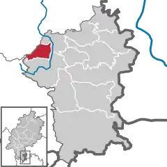 | |
 Fränkisch-Crumbach  Fränkisch-Crumbach | |
| Coordinates: 49°45′N 08°52′E | |
| Country | Germany |
| State | Hesse |
| Admin. region | Darmstadt |
| District | Odenwaldkreis |
| Government | |
| • Mayor (2023–29) | Matthias Horlacher[1] (SPD) |
| Area | |
| • Total | 16.1 km2 (6.2 sq mi) |
| Highest elevation | 500 m (1,600 ft) |
| Lowest elevation | 190 m (620 ft) |
| Population (2022-12-31)[2] | |
| • Total | 3,078 |
| • Density | 190/km2 (500/sq mi) |
| Time zone | UTC+01:00 (CET) |
| • Summer (DST) | UTC+02:00 (CEST) |
| Postal codes | 64407 |
| Dialling codes | 06164 |
| Vehicle registration | ERB |
| Website | www.fraenkisch-crumbach.de |
Geography
Location
Fränkisch-Crumbach lies in the middle Odenwald on the Gersprenz, which empties into the Main near Stockstadt am Main.
Neighbouring communities
Fränkisch-Crumbach borders in the northeast on the community of Brensbach, in the southeast on the community of Reichelsheim (both in the Odenwaldkreis), in the west on the town of Lindenfels (Kreis Bergstraße), in the northwest on the community of Fischbachtal and in the north on the town of Groß-Bieberau (both in Darmstadt-Dieburg).
Politics
The municipal election held on 26 March 2006 yielded the following results:
| Parties and voter communities | % 2006 |
Seats 2006 |
% 2001 |
Seats 2001 | |
| CDU | Christian Democratic Union of Germany | 38.6 | 9 | 34.9 | 8 |
| SPD | Social Democratic Party of Germany | 54.9 | 13 | 50.1 | 12 |
| GREENS | Bündnis 90/Die Grünen | 6.5 | 1 | 7.7 | 2 |
| ULF | Unabhängige Liste Fränkisch-Crumbach | – | – | 4.8 | 1 |
| FDP | Free Democratic Party | – | – | 2.6 | 0 |
| Total | 100.0 | 23 | 100.0 | 23 | |
| Voter turnout in % | 64.3 | 73.6 | |||
Mayor
Mayor Matthias Horlacher (SPD) was elected on 12 March 2023.
Culture and sightseeing
Buildings
- The Evangelical Church of Saint Lawrence (Kirche St. Laurentius) is built in the Romanesque style. It was given a steeple and a quire with rib vaulting in 1485. Worthy of note are the epitaphs, some of which come from the Renaissance.
- The Rodenstein Castle ruins, built about 1250
- The tomb of the Barons of Gemmingen on the main street
- The Schnellerts Castle ruins a few kilometres away.
Economy and infrastructure
Transport
The community is linked to the long-distance road network by Bundesstraße 38 (Weinheim–Roßdorf).
References
- "Ergebnisse der jeweils letzten Direktwahl von Landrätinnen und Landräte sowie (Ober-)Bürgermeisterinnen und (Ober-)Bürgermeister in Hessen, Stand 13.04.2023" (XLS) (in German). Hessisches Statistisches Landesamt.
- "Bevölkerung in Hessen am 31.12.2022 nach Gemeinden" (XLS) (in German). Hessisches Statistisches Landesamt. June 2023.
External links
- Fränkisch-Crumbach at Curlie (in German)
Towns and municipalities in Odenwaldkreis district | ||
|---|---|---|
Wappen des Landkreises Odenwaldkreis | ||