Gamawa
Gamawa is a Local Government Area of Bauchi State, Nigeria, bordering Yobe State in the east. Its headquarters are in the town of Gamawa.
Gamawa | |
|---|---|
LGA and town | |
 Gamawa Emir's Palace | |
 Gamawa Location in Nigeria | |
| Coordinates: 12°08′N 10°32′E | |
| Country | |
| State | Bauchi State |
| Area | |
| • Total | 2,925 km2 (1,129 sq mi) |
| Population (2006 census) | |
| • Total | 286,388 |
| Time zone | UTC+1 (WAT) |
| 3-digit postal code prefix | 752 |
| ISO 3166 code | NG.BA.GM |
It has an area of 2,925 km2 and a population of 286,388 at the 2006 census.
The predominant ethnic group in the area are the Fulani and the Karai-Karai living in the east.[1]
The postal code of the area is 752.[2]
Climate
The rainy season in Gamawa is typically hot, humid, and generally cloudy, whereas the dry season is hot and partly cloudy.[3][4]
Gamawa Emir's Palace
References
- "State maps". Nigerian National Bureau of Statistics. Archived from the original on 2010-05-01. Retrieved 2010-05-19.
- "Post Offices- with map of LGA". NIPOST. Archived from the original on 2012-11-26. Retrieved 2009-10-20.
- "Gamawa Climate, Weather By Month, Average Temperature (Nigeria) - Weather Spark". weatherspark.com. Retrieved 2023-08-31.
- "Gamawa, Bauchi, NG Climate Zone, Monthly Averages, Historical Weather Data". tcktcktck.org. Retrieved 2023-08-31.
State capital: Bauchi | ||
| Local Government Areas | 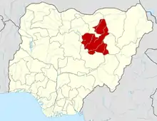 | |
Gamawa is boarded to the south by Dambam
This article is issued from Wikipedia. The text is licensed under Creative Commons - Attribution - Sharealike. Additional terms may apply for the media files.