Gayo Lues Regency
Gayo Lues Regency (Indonesian: Kabupaten Gayo Lues) is a regency in the Aceh Special Region of Indonesia. It is located on the island of Sumatra. The regency was created on 10 April 2002 under Statute UU 4/2002 from the northern part of Aceh Tenggara (Southeast Aceh Regency). Its capital is Blangkejeren. The regency covers an area of 5,549.91 square kilometres and had a population of 79,560 at the 2010 Census[2] and 99,532 at the 2020 Census;[3] the official estimate as at mid 2022 was 103,131.[1] Along with the Central Aceh Regency and the Bener Meriah Regency, it is home to the Gayo people.[4]
Gayo Lues Regency
Kabupaten Gayo Lues | |
|---|---|
 Coat of arms | |
| Motto: Musara ('United') | |
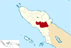 Location within Aceh | |
| Coordinates: 4°N 97°E | |
| Country | |
| Region | Sumatra |
| Province | |
| Established | 2002 |
| Regency seat | Blangkejeren |
| Government | |
| • Regent | Muhammad Amru |
| • Vice Regent | Said Sani |
| Area | |
| • Total | 5,549.91 km2 (2,142.83 sq mi) |
| Population (mid 2022 estimate)[1] | |
| • Total | 103,131 |
| • Density | 19/km2 (48/sq mi) |
| Time zone | UTC+7 (IWST) |
| Area code | (+62) 629 |
| Website | gayolueskab.go.id |

Economy
Ninety percent of the inhabitants make their living from farming and other food production. Products include:[5]
Logging is reportedly a major problem in the regency which is the least populated area of the province with less than 2% of the total population.[6]
Administrative districts
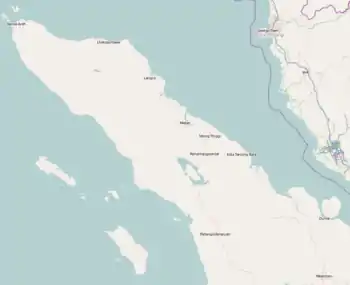
The regency is divided administratively into eleven districts (kecamatan), listed below with their areas and their populations at the 2010 Census[2] and the 2020 Census,[3] together with the official estimates as at mid 2022.[1] The table also includes the locations of the district administrative centres and the number of villages (gampong) in each district.
| Name of District (kecamatan) |
Area in km2 |
Pop'n 2010 Census |
Pop'n 2020 Census |
Pop'n mid-2022 Estimate |
Admin centre |
No. of villages |
|---|---|---|---|---|---|---|
| Kuta Panjang | 269.53 | 7,330 | 9,365 | 9,741 | Kuta Panjang | 12 |
| Blang Jerango | 382.42 | 6,379 | 7,355 | 7,500 | Buntul Gemuyang | 10 |
| Blangkejeren | 166.06 | 24,434 | 31,180 | 32,423 | Blangkejeren | 22 |
| Putri Betung | 996.85 | 6,607 | 9,142 | 9,657 | Gumpang | 13 |
| Dabun Gelang | 444.71 | 5,277 | 6,773 | 7,051 | Badak Bur Jumpe | 11 |
| Blang Pegayon | 272.18 | 5,099 | 6,406 | 6,641 | Cinta Maju | 12 |
| Pining | 1,350.09 | 4,320 | 5,112 | 5,239 | Pining | 9 |
| Rikit Gaib | 264.08 | 3,770 | 4,525 | 4,650 | Buntul Gemuya | 13 |
| Pantan Cuaca | 295.06 | 3,481 | 4,338 | 4,490 | Kenyaran | 11 |
| Terangun | 671.80 | 7,953 | 9,551 | 9,816 | Terangun | 25 |
| Tripe Jaya | 437.13 | 4,910 | 5,785 | 5,923 | Rerebe | 10 |
| Totals | 5,549.91 | 79,560 | 99,532 | 103,131 | Blangkejeren | 159 |
References
- Badan Pusat Statistik, Jakarta, 2023, Kabupaten Gayo Lues Dalam Angka 2023 (Katalog-BPS 1102001.1113)
- Biro Pusat Statistik, Jakarta, 2011.
- Badan Pusat Statistik, Jakarta, 2021.
- Library Information and Research Service (2004). The Middle East, abstracts and index. Northumberland Press. Retrieved 20 December 2010.
- "Gayo Lues" (PDF). Aceh Investment and Promotion Board. 2009. Archived from the original (PDF) on July 7, 2011. Retrieved December 24, 2010.
- Davies, Matthew N. (2006). Indonesia's war over Aceh: last stand on Mecca's porch. Taylor & Francis. pp. 45–. ISBN 978-0-415-37239-8. Retrieved 21 December 2010.
Regencies and cities of Aceh | ||
|---|---|---|
Capital: Banda Aceh | ||
| Regencies |  | |
| Cities | ||