Gerswalde
Gerswalde is a municipality in the Uckermark district, in Brandenburg, Germany.
Gerswalde | |
|---|---|
Location of Gerswalde within Uckermark district  | |
 Gerswalde  Gerswalde | |
| Coordinates: 53°10′00″N 13°46′00″E | |
| Country | Germany |
| State | Brandenburg |
| District | Uckermark |
| Municipal assoc. | Gerswalde |
| Government | |
| • Mayor (2019–24) | Ernst Zeiger[1] |
| Area | |
| • Total | 96.79 km2 (37.37 sq mi) |
| Elevation | 52 m (171 ft) |
| Population (2021-12-31)[2] | |
| • Total | 1,554 |
| • Density | 16/km2 (42/sq mi) |
| Time zone | UTC+01:00 (CET) |
| • Summer (DST) | UTC+02:00 (CEST) |
| Postal codes | 17268 |
| Dialling codes | 039887 |
| Vehicle registration | UM |
| Website | www.gerswalde-uckermark.de |
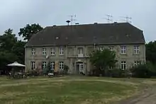
Arnimswalde
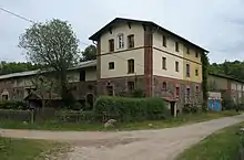
Manor in Friedenfelde
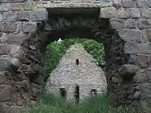
Church ruin in Berkenlatten
Demography
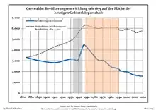
Development of Population since 1875 within the Current Boundaries (Blue Line: Population; Dotted Line: Comparison to Population Development of Brandenburg state; Grey Background: Time of Nazi rule; Red Background: Time of Communist rule)
|
|
|
References
- Landkreis Uckermark Wahl der Bürgermeisterin / des Bürgermeisters, accessed 4 July 2021.
- "Bevölkerungsentwicklung und Flächen der kreisfreien Städte, Landkreise und Gemeinden im Land Brandenburg 2021" (PDF). Amt für Statistik Berlin-Brandenburg (in German). June 2022.
- Detailed data sources are to be found in the Wikimedia Commons.Population Projection Brandenburg at Wikimedia Commons
Towns and municipalities in Uckermark | ||
|---|---|---|
| Coat of Arms of Uckermark district | |
Wikimedia Commons has media related to Gerswalde (municipality).
This article is issued from Wikipedia. The text is licensed under Creative Commons - Attribution - Sharealike. Additional terms may apply for the media files.